crash_reports
8 rows where date = "2019-05-06"
This data as json, CSV (advanced)
Suggested facets: intersection, speed_limit, hit_run, keywords, dcc, dcc_code, datetime (date), date (date), retrieved (date), keywords (array), dcc (array)
Case
number:
Date:
2019-05-06
Time:
07:10
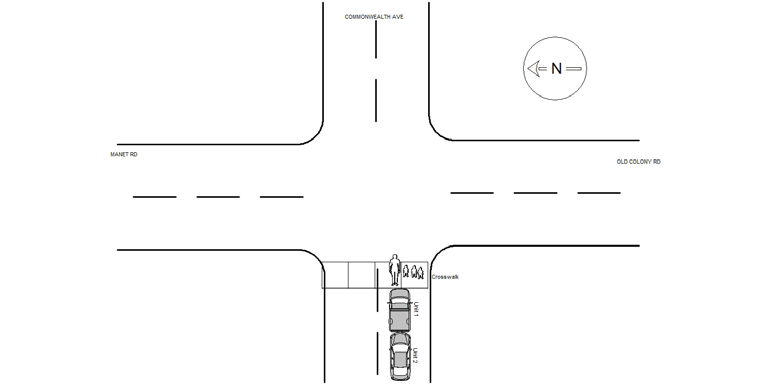
Address:
COMMONWEALTH AVE & OLD COLONY RD
Speed
limit:
30
Violation
cited:
no
Narrative:
VEHICLE #1 WAS TRAVELING STRAIGHT AHEAD ON COMMONWEALTH AVE, HEADING EASTBOUND. SUDDENLY AT THE INTERSECTION OF OLD COLONY RD, WITHOUT WARNING, A WOMAN CROSSED THE STREET WITH THREE YOUNG CHILDREN.(THE WOMAN WAS IN THE CROSSWALK). VEHICLE #1 STOPPED IMMEDIATELY, UNFORTUNATELY VEHICLE #2 COULD NOT STOP IN TIME AND STRUCK VEHICLE #1. NO INJURIES REPORTED. VEHICLE #2 TOWED BY TODYS TOWING ON NEWTON.
Keywords:
Crosswalk
Dcc:
[]
Report
url:
Image
url:
Latitude:
42.3371123
Longitude:
-71.1724493
Location:
Case
number:
Date:
2019-05-06
Time:
10:59
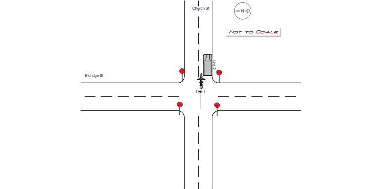
Address:
CHURCH ST & ELDREDGE ST
Speed
limit:
25
Violation
cited:
no
Narrative:
Oper of motorcycle ( Vehicle #1) stated she was traveling WB on Church Street and while going through intersection at Eldridge Street she moved to the right because of on coming vehicle. She underestimated the size of her sidecar on the motorcycle and sideswiped vehicle #2 which was parked on Church Street. A note was left on vehicle # 2 informing her about report. Sidecar wasn't added to diagram because it is not an option. No injuries. No tickets.
Keywords:
Citation
Dcc:
Over-steering
Report
url:
Image
url:
Latitude:
42.3531019
Longitude:
-71.1842085
Location:
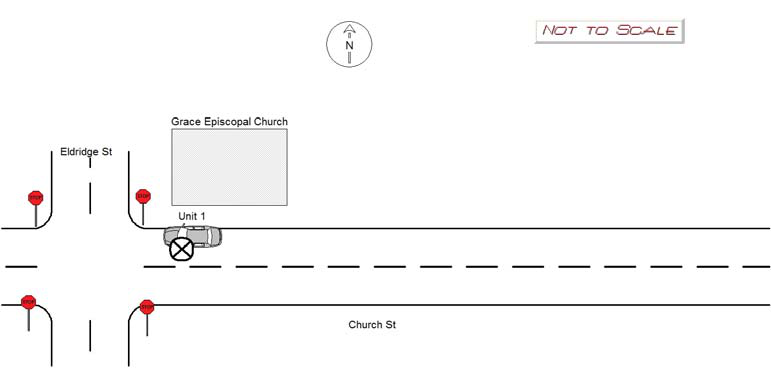
Case
number:
Date:
2019-05-06
Time:
11:32
Address:
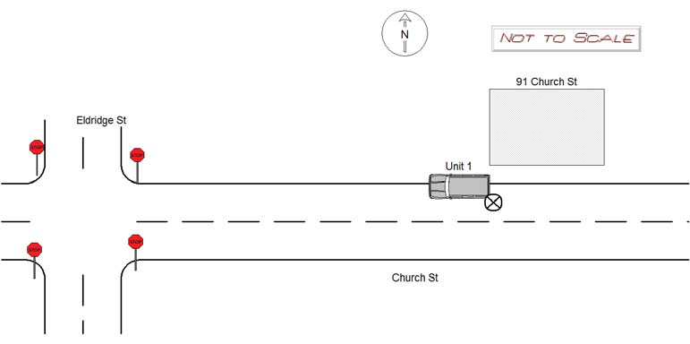
91 CHURCH ST
Speed
limit:
25
Violation
cited:
no
Narrative:
Vehicle # 1 was parked on Church Street in front of #91 at 09:00 on 5/6/19 and owner noticed damage on 5/6/19 at 11:15. Appears that unknown vehicle # 2 was coming WB on Church St and sideswiped vehicle #1. No tows.
Keywords:
[]
Dcc:
Unknown
Report
url:
Image
url:
Latitude:
42.3527677
Longitude:
-71.1833068
Location:
Case
number:
Date:
2019-05-06
Time:
12:53
Address:
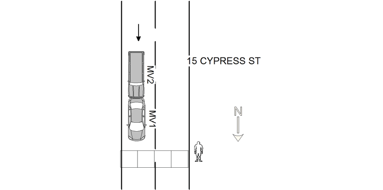
15 CYPRESS ST
Speed
limit:
25
Violation
cited:
no
Narrative:
OPER OF MV#1 STATED THAT HE HAD STOPPED FOR A PEDESTRIAN CROSSING THE ROAD, WHEN MV#2 STRUCK HIM FROM BEHIND. OPER OF MV#2 COULD NOT STOP IN TIME FOR A STOPPED MV#1, AND STRUCK THE VEHICLE FROM BEHIND. MV#1 SUSTAINED MODERATE REAR END DAMAGE AND WAS TOWED (PRIVATE). MV#2 SUSTAINED MODERATE FRONT DAMAGE AND WAS TOWED (PRIVATE)
Keywords:
Moderate, Ped
Dcc:
Followed too closely
Report
url:
Image
url:
Latitude:
42.3285638
Longitude:
-71.1951188
Location:
Case
number:
Date:
2019-05-06
Time:
11:36
Address:
76 ELDREDGE ST
Speed
limit:
25
Violation
cited:
no
Narrative:
Vehicle # 1 was parked on Church Street at the intersection with Eldredge St. There was fresh damage to the front half of the vehicle. Another vehicle was struck on this road between 09:00 and 11:15. I left a note on Vehicle # 1 to notify her that a police report was taken.
Keywords:
[]
Dcc:
Unknown
Report
url:
Image
url:
Latitude:
42.3531774
Longitude:
-71.1834229
Location:
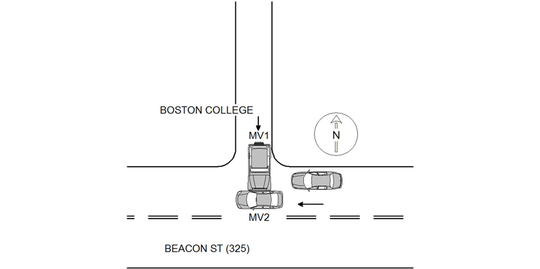
Case
number:
Date:
2019-05-06
Time:
14:27
Address:
325 BEACON ST
Speed
limit:
25
Violation
cited:
no
Narrative:
OPER OF MV1 STATED THAT HE WAS PULLING OUT FROM A BOSTON COLLEGE DRIVEWAY (ON TO BEACON ST), WHEN MV2 DROVE AROUND ANOTHER STOPPED VEHICLE, CAUSING THEM TO COLLIDE. OPER OF MV#2 STATED THAT HE WAS TRAVELLING WB ON BEACON ST. OPER OF MV#2 STATED THAT HE DROVE AROUND A STOPPED VEHICLE (LEFT SIDE) AND ENTERED A LEFT TURN LANE. WHILE DOING SO, MV#1 EMERGED FROM A DRIVEWAY (WB SIDE) AND THE VEHICLES COLLIDED. MV1 SUSTAINED MINOR FRONT DAMAGE. MV2 SUSTAINED MODERATE PASSENGER SIDE DAMAGE.
Keywords:
Moderate
Dcc:
Unknown
Report
url:
Image
url:
Latitude:
42.3333408
Longitude:
-71.1719303
Location:
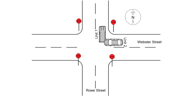
Case
number:
Date:
2019-05-06
Time:
14:47
Address:
ROWE ST & WEBSTER ST
Speed
limit:
25
Violation
cited:
no
Narrative:
The operator of MV#1 stated that prior to the crash she was traveling north on Rowe St. Operator #1 came to the intersection at Webster St, stopped and observed no other cars at the intersection and proceeded straight thru the intersection. While in the intersection, operator #1 observed MV#2 traveling west on Webster St travel thru the stop sign without stopping and strike her MV. MV#2 did not stop, but instead continued on Webster St towards Auburndale Square. Operator #1 describes MV#2 as a gold sedan being operated by a 55-70 year old female wearing large sunglasses. A search of the area was negative.
Keywords:
Crash, Solar
Dcc:
[]
Report
url:
Image
url:
Latitude:
42.348768
Longitude:
-71.241021
Location:
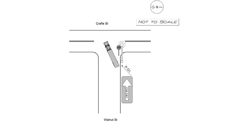
Case
number:
Date:
2019-05-06
Time:
17:23
Address:
CRAFTS ST & WALNUT ST
Speed
limit:
25
Violation
cited:
no
Narrative:
MV1 stated he was attempting to turn left onto Crafts St from Walnut St when the back end of his tractor trailer made contact with a light pole and knocked it over due to "the lane not being made for these kinds of trucks." The trailer sustained minor damage and the light pole was completely uprooted and across the sidewalk. Photos of the scene were captured and turned over to the IT Bureau. Daigle Electric notified of the damage to the pole.
Keywords:
Pictures
Dcc:
Inattention
Report
url:
Image
url:
Latitude:
42.359029
Longitude:
-71.2122128
Location:
Advanced export
JSON shape: default, array, newline-delimited, object
CREATE TABLE "crash_reports" (
   [case_number] TEXT PRIMARY KEY,
   [datetime] TEXT,
   [date] TEXT,
   [time] TEXT,
   [address] INTEGER,
   [street1] TEXT,
   [street2] TEXT,
   [intersection] INTEGER,
   [speed_limit] INTEGER,
   [hit_run] INTEGER,
   [violation_cited] INTEGER,
   [narrative] TEXT,
   [keywords] TEXT,
   [dcc] TEXT,
   [dcc_code] TEXT,
   [report_url] TEXT,
   [image_url] TEXT
, [geocoded_address] TEXT, [latitude] TEXT, [longitude] TEXT, [manual_geocode] INTEGER, [retrieved] TEXT);