crash_reports
8 rows where date = "2020-01-18"
This data as json, CSV (advanced)
Suggested facets: intersection, speed_limit, violation_cited, keywords, dcc, dcc_code, datetime (date), date (date), retrieved (date), keywords (array), dcc (array)
Case
number:
Date:
2020-01-18
Time:
01:05
Address:
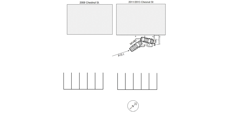
1205 CHESTNUT ST
Speed
limit:
15
Violation
cited:
yes
Narrative:
Based on observations, and statements made, the following occurred. The operator of M/V#1 stated that at approx. 21:30 hrs. he parked M/V#1 in a parking lot behind, and parallel to 2011/2013 Chestnut St., in a clearly defined parking spot. M/V#2 appeared to have struck the right rear of M/V#1 pushing it several feet to the left, causing M/V#1's left rear door to impact on a steel balcony support pole (of 2011/2013 Chestnut St. causing damage to M/V#1's left rear door, but no apparent damage to the pole). It appeared that M/V#2 attempted to pull forward, causing damage a long the entire right side of M/V#1, and pushing it a few feet forward, then struck a hand rail causing the hand rail to bend inwards. M/V#2 had left behind a large amount of debris, including MA License Plate Veteran RG9. NPD Dispatch contacted Boston Police (E-5) and requested a unit got to 142 Wren St. Apt/ R1 and make contact with the owner of M/V#2. At approx. 0220 hrs, I contacted BPD (E-5) and was informed that Boston PD confirmed that M/V#2 was at 142 Wren St. with heavy front end damage, missing the front license plate. I was also informed that they made contact with the registered owner and advised him to contact Newton P.D. (See NPD incident report #20003150) After speaking to Robert Godnio, he informed me that his son Wayne Godino had been driving the vehicle on 01/17/2020 at approx. 2100 Hrs. I spoke to Wayne Godino, who stated that someone hit his car behind The Builtmore, and took off, then he left. I advised him that the evidence showed that he struck a parked car. Wayne asked how do you know? there weren't any pieces" I advised him that I recovered the license plate to his fathers car, and he stated "whatever". Charges will be sought for MGL C90 S24 Leaving the scene property damage.
Keywords:
Crash
Dcc:
Other improper action
Report
url:
Image
url:
Latitude:
42.3091897
Longitude:
-71.2211671
Location:
Case
number:
Date:
2020-01-18
Time:
14:09
Address:
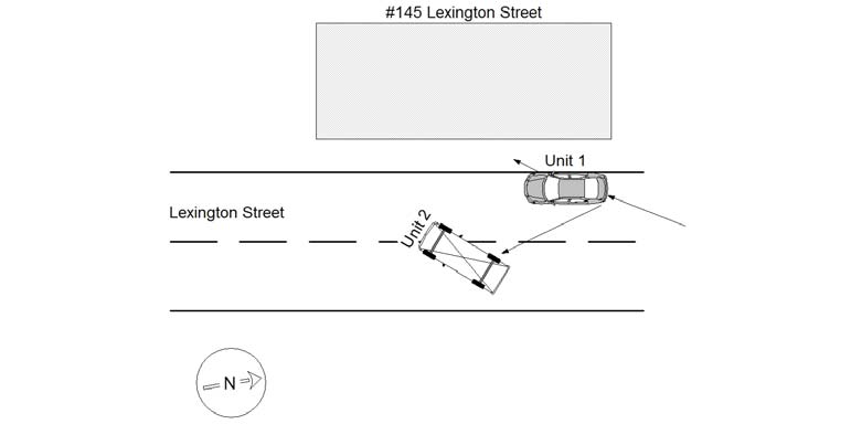
145 LEXINGTON ST
Speed
limit:
30
Violation
cited:
no
Narrative:
The owner of MV#1 stated that her MV was parked and unoccupied in front of #145 Lexington St when it was struck by MV#2. The operator of MV#2 stated that he was traveling south on Lexington St when either a cat or squirrel ran in front of his MV and he tried to avoid animal by turning right and struck MV#1, which was parked and unoccupied. MV#2 then rolled over after striking MV#1. No injuries, both MV's towed.
Keywords:
[]
Dcc:
Swerving
Report
url:
Image
url:
Latitude:
42.3557274
Longitude:
-71.2418991
Location:
Case
number:
Date:
2020-01-18
Time:
18:55
Address:
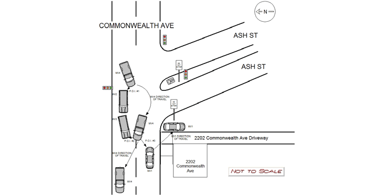
2202 COMMONWEALTH AVE
Speed
limit:
35
Violation
cited:
no
Narrative:
MV1 was operating eastbound on Commonwealth Ave (public way), and MV2, MV3, and MV4 were all operating westbound on Commonwealth Ave by Ash St. MV3 was stopped with her left blinker on waiting to turn into her driveway and MV2 was stopped behind MV3. MV4 attempted to stop but due to the weather conditions and slippery road conditions he was unable to and slid out. While sliding out MV4 struck MV2 in the left rear bumper, struck MV3 in the front left bumper and wheel well, and then struck MV1 in the front left bumper. MV1, MV2 and MV3 sustained sever damage. MV3 was able to park in her driveway but both MV1 and MV3 were towed by Todys. No injuries reported. MV4 operator was issued MA Uniform Citation # T2080303 C.O. 19-71 Following Too Closely (local).
Keywords:
Citation
Dcc:
[]
Report
url:
Image
url:
Latitude:
42.3470352
Longitude:
-71.2518995
Location:
Case
number:
Date:
2020-01-18
Time:
19:39
Address:
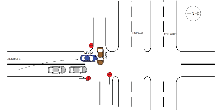
BOYLSTON ST & CHESTNUT ST
Speed
limit:
25
Violation
cited:
no
Narrative:
Based on observations, and statements made, the following occurred. M/V#1 was traveling east on the Rte 9 off ramp, and came to a stop, at the intersection of Chestnut St. He stated that north bound traffic, on Chestnut St. had stopped to allow him to enter the intersection, and as he did, he was struck by M/V#2. The operator of M/V#2 stated that she was traveling north on Chestnut St., and as she came over the hill, she attempted to stop, but her car began to slide. She stated that to avoid hitting the stopped traffic in front of her, she pulled into the left lane, and her M/V continued to slide downhill, past the stop sign, and into the intersection, where she collided with M/V#1. The passenger of M/V#2 corroborated operator #2's statements.
Keywords:
[]
Dcc:
Too fast for conditions
Report
url:
Image
url:
Latitude:
42.3169482
Longitude:
-71.2257627
Location:
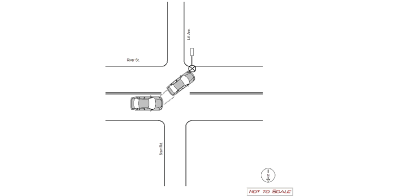
Case
number:
Date:
2020-01-18
Time:
19:37
Address:
RIVER ST & LILL AVE
Speed
limit:
25
Violation
cited:
no
Narrative:
MV #1 was traveling westbound on River St. when the operator lost control of her vehicle due to the snowy conditions and crashed into the street sign on the corner of River St. and Lill Ave. The operator was not injured and the vehicle was driven from the scene. The City of Newton was notified regarding the damaged sign and photographs of the sign were taken on the N492 camera and submitted to the Newton Police It Bureau.
Keywords:
Crash, Pictures, Snow
Dcc:
Unknown
Report
url:
Image
url:
Latitude:
42.3556527
Longitude:
-71.236118
Location:
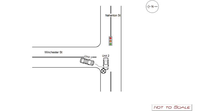
Case
number:
Date:
2020-01-18
Time:
18:47
Address:
NAHANTON ST & WINCHESTER ST
Speed
limit:
30
Violation
cited:
no
Narrative:
MV 1 was attempting to turn right west onto Nahanton St when she began to slide and struck the front side of MV 2. MV 1 was attempting to stop at the redlight but could not effectively due to inclimate weather. MV 2 was traveling straight west on Nahanton St when MV 1 slid into her due to inclimate weather. The front left airbag deployed for MV 2 during the collision. EMS and Newton Fire responded. The operator of MV 2 refused medical treatment on scene. Both vehicles were towed by Tody's due to being disabled on a public way. Towed motor vehicle sheets were filled out and filed accordingly.
Keywords:
Airbag, Ems, Fire
Dcc:
Swerving
Report
url:
Image
url:
Latitude:
42.2969738
Longitude:
-71.2009796
Location:
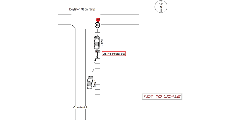
Case
number:
Date:
2020-01-18
Time:
19:53
Address:
CHESTNUT ST
Speed
limit:
30
Violation
cited:
no
Narrative:
MV 1 was traveling north on Chestnut St when she slid into the curb striking a USPS post mail box and stop sign. The operator of MV 1 lost control of the vehicle due to inclimate weather and slid into the side of the road striking the objects. The operator was not injured by the crash. Pictures of the mailbox and stop sign were taken and passed into the Newton Police IT department. The vehicle was towed due to it being disabled on a public way. A towed motor vehicle inventory sheet was filled out and filed. Postal police was notified of the downed box.
Keywords:
Crash, Pictures
Dcc:
Swerving
Report
url:
Image
url:
Latitude:
42.3307093
Longitude:
-71.2247899
Location:
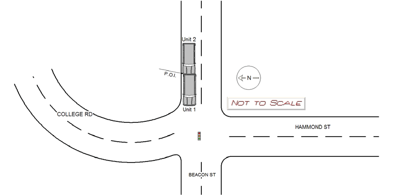
Case
number:
Date:
2020-01-18
Time:
22:25
Address:
BEACON ST & HAMMOND ST
Speed
limit:
25
Violation
cited:
no
Narrative:
Vehicle #1 stated they were stopped at the traffic lights on beacon st facing westbound when they were struck in the rear by Vehicle #2. Vehicle #2 stated they were traveling westbound on beacon st and attempted to stop for the red light. Vehicle #2 stated they started to slide due to the snow and was unable to stop and struck Vehicle #1 in the rear. Vehicle #1 had major damage to the rear and was unable to be driven. Vehicle #2 had major damage to the front and was unable to be driven. Both vehicle were towed away by tody's towing. Both operators and passenger were asked if they were injured and all parties stated they were not injured and refused any medical treatment.
Keywords:
Snow
Dcc:
Too fast for conditions
Report
url:
Image
url:
Latitude:
42.3328654
Longitude:
-71.1727828
Location:
Advanced export
JSON shape: default, array, newline-delimited, object
CREATE TABLE "crash_reports" (
   [case_number] TEXT PRIMARY KEY,
   [datetime] TEXT,
   [date] TEXT,
   [time] TEXT,
   [address] INTEGER,
   [street1] TEXT,
   [street2] TEXT,
   [intersection] INTEGER,
   [speed_limit] INTEGER,
   [hit_run] INTEGER,
   [violation_cited] INTEGER,
   [narrative] TEXT,
   [keywords] TEXT,
   [dcc] TEXT,
   [dcc_code] TEXT,
   [report_url] TEXT,
   [image_url] TEXT
, [geocoded_address] TEXT, [latitude] TEXT, [longitude] TEXT, [manual_geocode] INTEGER, [retrieved] TEXT);