crash_reports
2 rows where date = "2021-10-14" and dcc contains "Unknown"
This data as json, CSV (advanced)
Suggested facets: datetime (date), date (date), retrieved (date), keywords (array), dcc (array)
Case
number:
Date:
2021-10-14
Time:
12:59
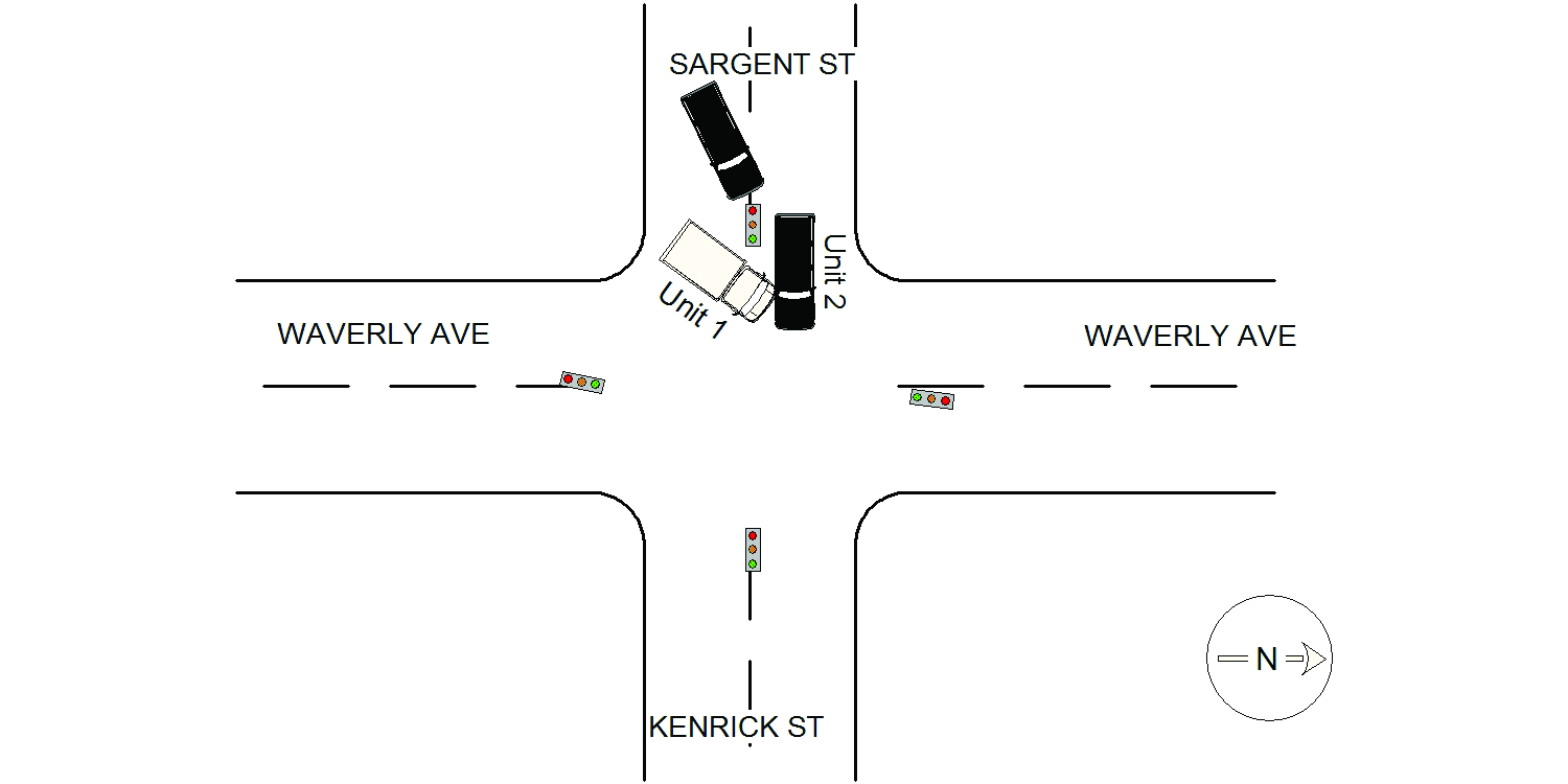
Address:
SARGENT ST & WAVERLEY AVE
Speed
limit:
30
Violation
cited:
no
Narrative:
On October 14th, 2021 at approximately 12:59 hours while working N491 I responded to the intersection of Sargent St @ Waverley Ave for a report of a MV crash. On my arrival I located both involved vehicle parked on the other side of the intersection on Kenrick St. Vehicle #1 was a United States Postal Truck operated by a Liam Cunningham. He stated he was stopped on Sargent St/ E/B @ Waverly Ave for the traffic light/pedestrian walk light. He further stated there were two women walking across the street from the northeast side to the southwest side. His light turned green but waited until the women made it to the right of his truck. Operator#1 then began to make a left turn onto Waverely Ave when vehicle #2 who was behind his vehicle drove around him at the same time he began his turn causing the crash. Vehicle #2 was a 2021 Black Mazda C X utility, CA. tag, 8XDZ707, operated by a Edward Ramirez. He stated he was stopped behind vehicle #1/ UPS truck while the light was red. He then stated the light turned green but the UPS truck with its flashers on wasn't moving. Operator then assumed the UPS truck was stopped making a delivery and began to go around him. As he got to the intersection the UPS truck suddenly began to go forward attempting to make a left turn causing his vehicle to get struck by the truck as he 9vehicle #2) was attempting to go straight across the intersection to Kenrick St. Postal truck are government owned vehicle thus have no plates attatched and carry no registations/ insurance.
Keywords:
Crash, Walk
Dcc:
Unknown
Report
url:
Image
url:
Latitude:
42.3467369
Longitude:
-71.1809733
Location:
Case
number:
Date:
2021-10-14
Time:
13:03
Address:
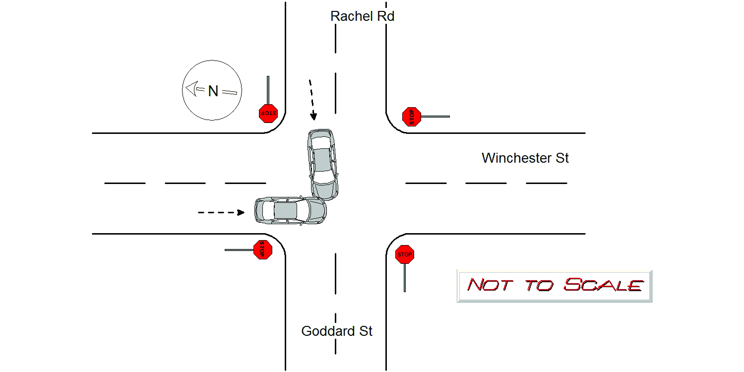
RACHEL RD & WINCHESTER ST
Speed
limit:
25
Violation
cited:
no
Narrative:
Mv#1 operator stated she came to a stop (four-way stop signs) on Winchester St S/B. #1 stated she looked to her left, a Mv was already stopped on Rachel Rd W/B. #1 stated she yielded to that Mv, that Mv then proceeded through the intersection. #1 stated she then proceeded next, attempting to continue straight ahead. #1 stated at that time, Mv#2 suddenly emerged from Rachel Rd W/B into the intersection directly behind the first Mv. #1 stated this was when her Mv was struck on her driver's side front end by #2. #1 sustained significant front end damage, rendered inoperable and was towed by Tody's. #2 operator stated she came to a stop at the end of Rachel Rd W/B. #2 stated at that time, she thought she had the right of way and attempted to proceed straight ahead through the intersection onto Goddard St. This was when the collision occurred with #1. #2 sustained significant passenger side front end damage, rendered inoperable and was towed by Tody's. Operator of MV#1 had a valid German License. No injuries.
Keywords:
[]
Dcc:
Unknown
Report
url:
Image
url:
Latitude:
42.3064293
Longitude:
-71.2056837
Location:
Advanced export
JSON shape: default, array, newline-delimited, object
CREATE TABLE "crash_reports" (
   [case_number] TEXT PRIMARY KEY,
   [datetime] TEXT,
   [date] TEXT,
   [time] TEXT,
   [address] INTEGER,
   [street1] TEXT,
   [street2] TEXT,
   [intersection] INTEGER,
   [speed_limit] INTEGER,
   [hit_run] INTEGER,
   [violation_cited] INTEGER,
   [narrative] TEXT,
   [keywords] TEXT,
   [dcc] TEXT,
   [dcc_code] TEXT,
   [report_url] TEXT,
   [image_url] TEXT
, [geocoded_address] TEXT, [latitude] TEXT, [longitude] TEXT, [manual_geocode] INTEGER, [retrieved] TEXT);