crash_reports
3 rows where "date" is on date 2019-04-08 and speed_limit = 30
This data as json, CSV (advanced)
Suggested facets: intersection, datetime (date), date (date), retrieved (date), keywords (array), dcc (array)
Case
number:
Date:
2019-04-08
Time:
08:58
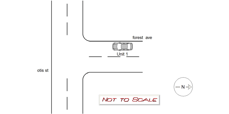
Address:
FOREST AVE & OTIS ST
Speed
limit:
30
Violation
cited:
no
Narrative:
ON 4-8-19 AT APPROX. 0858HRS. WHILE WORKING N492 I TOOK A REPORT FOR MOTOR VEHICLE CRASH. UPON ARRIVAL AT THE INTERSECTION OF FOREST AVE. AND OTIS ST. I SPOKE TO THE OPERATOR OF VEHICLE #1. DRIVER STATES HE WAS TRAVELING S-BOUND ON FOREST HEADING TOWARD OTIS WHEN HIS VEHICLES RIGHT FRONT TIRE FELL INTO A LARGE HOLE IN THE STREET. UPON FURTHER INSPECTION I COULD SEE THAT A CATCH BASIN HAD COLLAPSED AND FORMED A LARGE HOLE IN THE STREET. THERE WERE NO VISIBLE SIGNS OF DAMAGE TO VEHICLE #1 AND THE OPERATOR REPORTED NO INJURIES. ADVISED TO CONTACT INSURANCE COMPANY. CITY OF NEWTON WAS NOTIFIED. I PLACED THREE ORANGE CONES AROUND THE HOLE TO AVOID FURTHER ACCIDENTS. COMP. LEFT THE AREA BEFORE PICTURES OF HIS VEHICLE COULD BE TAKEN.
Keywords:
Crash, Pictures
Dcc:
[]
Report
url:
Image
url:
Latitude:
42.346448
Longitude:
-71.216017
Location:
Case
number:
Date:
2019-04-08
Time:
13:06
Address:
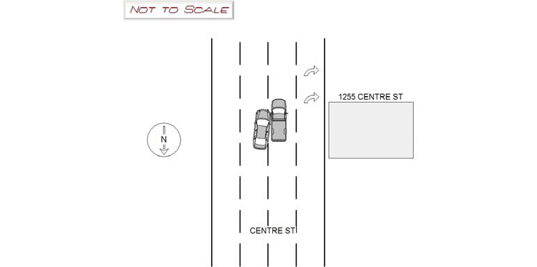
1255 CENTRE STREET
Speed
limit:
30
Violation
cited:
no
Narrative:
Operator of MV1 (Ma reg CHE1) stated he was traveling SB on Centre Street approaching the intersection of Beacon St when his vehicle was struck on the driver's side door. Operator of MV1 stated he was in the second line when a MV from the left side entered into his lane hitting his running board. Operator of MV1 stated he never saw this vehicle attempting to enter into his lane. Operator of MV2 (Ma reg 6pw879) stated she was traveling SB on Centre Street approaching the intersection of Beacon St when she attempted to enter into the adjacent lane. Operator of MV2 stated she put on her right blinker and attempted to enter the lane to the left. Operator of MV2 front passenger side bumper struck MV1's driver's side running board. There was very minor damage to the running board on MV1. MV2 had more significant damage to the front bumper area. Both parties stated they were not injured at this time. Both vehicles were able to operate without any incidents.
Keywords:
[]
Dcc:
Failed to yield
Report
url:
Image
url:
Latitude:
42.3304655
Longitude:
-71.1950492
Location:
Case
number:
Date:
2019-04-08
Time:
17:06
Address:
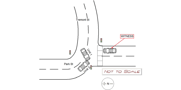
PARK ST & TREMONT ST
Speed
limit:
30
Violation
cited:
no
Narrative:
On Monday 4/8/2019 at approx. 1706 hrs, while assigned to N-494, I responded to the intersection of Park St and Tremont St for a 2 car MVA. On scene both operators said they were uninjured. Operator of vehicle #1 states that he was traveling WB on Tremont St and attempted to take a left onto Park St while observing a green light. He said that he saw vehicle #2 not moving with the operator "looking down" and "probably looking at her phone." He then began to turn left but then he said that vehicle #2 suddenly moved forward and they collided. Operator of vehicle #1 believes he had his left turn signal activated. Operator of vehicle #2 states that she was on Park St, facing SB, about to turn left onto Tremont St. She said that prior to the accident that she was looking at her "Waze" app for directions on her phone just prior to the accident. She believes that she was moving "slowly" before the collision.
Keywords:
Crash, Phone
Dcc:
Distracted
Report
url:
Image
url:
Latitude:
42.3549379
Longitude:
-71.1820848
Location:
Advanced export
JSON shape: default, array, newline-delimited, object
CREATE TABLE "crash_reports" (
   [case_number] TEXT PRIMARY KEY,
   [datetime] TEXT,
   [date] TEXT,
   [time] TEXT,
   [address] INTEGER,
   [street1] TEXT,
   [street2] TEXT,
   [intersection] INTEGER,
   [speed_limit] INTEGER,
   [hit_run] INTEGER,
   [violation_cited] INTEGER,
   [narrative] TEXT,
   [keywords] TEXT,
   [dcc] TEXT,
   [dcc_code] TEXT,
   [report_url] TEXT,
   [image_url] TEXT
, [geocoded_address] TEXT, [latitude] TEXT, [longitude] TEXT, [manual_geocode] INTEGER, [retrieved] TEXT);