crash_reports
1 row where "date" is on date 2020-05-26 and dcc = "["Wrong way"]"
This data as json, CSV (advanced)
Suggested facets: datetime (date), date (date), retrieved (date), keywords (array), dcc (array)
Case
number:
Date:
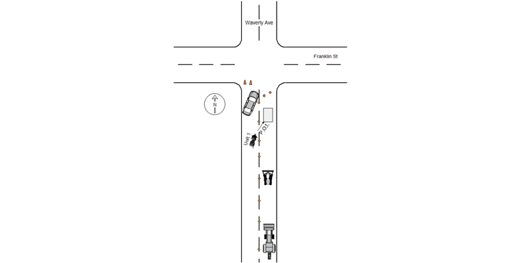
2020-05-26
Time:
13:19
Address:
FRANKLIN ST & WAVERLEY AVE
Speed
limit:
30
Violation
cited:
yes
Narrative:
Operator 1 stated he was driving northbound in the southbound lane on Waverly Ave due to construction in the northbound lane. Operator 1 stated as he approached the intersection of Franklin St he was confused on which side of the cones he should be on and crossed over the marked lanes and past the cones and subsequently drove into a 2ft X 2Ft X 8 inch deep construction hole. Operator 1 stated he sustained no injuries and was checked out by medic 3 in which he signed a patient refusal. MV1 sustained minor damage, scuffs, to the right side leather saddle bag. The northbound lane was coned off for more than a block due to a Feeney Brothers construction detail with Officer Edrehi manning the post. A backhoe, a bobcat and a generator all occupied the northbound lane that was clearly blocked off. Officer Edrehi stated that due to Feeney Brother construction detail Waverly Ave was diverted to 1 way traffic travelling northbound in the southbound lane. Officer Edrehi stated he observed Operator 1 following multiple vehicle and as he approached the intersection of Franklin St Operator 1 crossed over the marked lanes and past the cones and at a low speed fell into the construction hole. Due to the statements provided I issued Operator 1 MA Uniform Citation T1269531 for C89 S4A Marked Lanes violation (warning). Operator 1 was assisted in lifitng his motorcycle and drove off without further issues.
Keywords:
Citation, Speed
Dcc:
Wrong way
Report
url:
Image
url:
Latitude:
42.3492419
Longitude:
-71.1804564
Location:
Advanced export
JSON shape: default, array, newline-delimited, object
CREATE TABLE "crash_reports" (
   [case_number] TEXT PRIMARY KEY,
   [datetime] TEXT,
   [date] TEXT,
   [time] TEXT,
   [address] INTEGER,
   [street1] TEXT,
   [street2] TEXT,
   [intersection] INTEGER,
   [speed_limit] INTEGER,
   [hit_run] INTEGER,
   [violation_cited] INTEGER,
   [narrative] TEXT,
   [keywords] TEXT,
   [dcc] TEXT,
   [dcc_code] TEXT,
   [report_url] TEXT,
   [image_url] TEXT
, [geocoded_address] TEXT, [latitude] TEXT, [longitude] TEXT, [manual_geocode] INTEGER, [retrieved] TEXT);