crash_reports
2 rows where "date" is on date 2022-01-14, keywords contains "Fire" and speed_limit = 25
This data as json, CSV (advanced)
Suggested facets: datetime (date), date (date), retrieved (date), keywords (array), dcc (array)
Case
number:
Date:
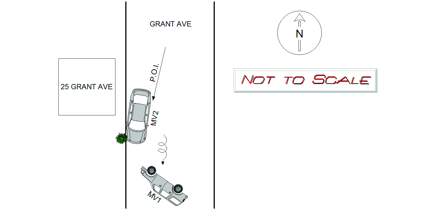
2022-01-14
Time:
16:45
Address:
25 GRANT AVE
Speed
limit:
25
Violation
cited:
no
Narrative:
The operator of MV1 (GEFFIN, Bennie - MA Reg 373N60) stated he was traveling Southbound on Grant Ave. when he jerked the wheel to avoid the left rear end of MV2 (MA Reg 2NEB55). MV2 was parked Southbound at 25 Grant Ave. As a result, MV1 clipped MV2, rolled over, and landed on its left side. GEFFIN and the passenger, GEFFIN, Gillian, were trapped in the vehicle upon my arrival, and were freed by Newton Fire. Both parties were evaluated by the medics and signed refusals with no injuries. MV1 sustained damage to all sides of the vehicle. MV2 sustained damage to the left side and right front as a result of sliding into a tree. Both vehicles were towed from the scene by Todys.
Keywords:
Fire, Tree
Dcc:
Over-steering
Report
url:
Image
url:
Latitude:
42.3384621
Longitude:
-71.1842583
Location:
Case
number:
Date:
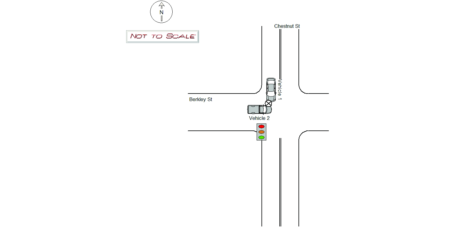
2022-01-14
Time:
19:01
Address:
BERKELEY ST & CHESTNUT ST
Speed
limit:
25
Violation
cited:
yes
Narrative:
On 1/14/22 at 1901 hrs, Newton Police and Fire were dispatched to the intersection of Chestnut St. and Berkeley St. for a motor vehicle accident involving two vehicles. Upon arrival, MV#1 was observed facing southbound in the middle of intersection with heavy front end damage. MV#2 was observed in the intersection facing eastbound, also with heavy front end damage as well as air bag deployment. Both operators insisted they had green lights as they passed through the intersection. Both operators denied any injuries and Tody's Tow Service was contacted to remove the vehicles from the roadway. Based on further investigation, the operator of MV#1 was charged with Mgl. Ch. 89/9, 90/24J and 90/24E.
Keywords:
Crash, Fire
Dcc:
Signs/Signals
Report
url:
Image
url:
Latitude:
42.3411624
Longitude:
-71.2235525
Location:
Advanced export
JSON shape: default, array, newline-delimited, object
CREATE TABLE "crash_reports" (
   [case_number] TEXT PRIMARY KEY,
   [datetime] TEXT,
   [date] TEXT,
   [time] TEXT,
   [address] INTEGER,
   [street1] TEXT,
   [street2] TEXT,
   [intersection] INTEGER,
   [speed_limit] INTEGER,
   [hit_run] INTEGER,
   [violation_cited] INTEGER,
   [narrative] TEXT,
   [keywords] TEXT,
   [dcc] TEXT,
   [dcc_code] TEXT,
   [report_url] TEXT,
   [image_url] TEXT
, [geocoded_address] TEXT, [latitude] TEXT, [longitude] TEXT, [manual_geocode] INTEGER, [retrieved] TEXT);