crash_reports
3 rows where "datetime" is on date 2019-01-20 and dcc contains "Unknown"
This data as json, CSV (advanced)
Suggested facets: intersection, hit_run, datetime (date), date (date), retrieved (date), keywords (array), dcc (array), dcc_code (array)
Case
number:
Date:
2019-01-20
Time:
08:22
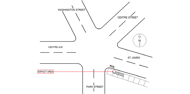
Address:
1 ST JAMES ST
Speed
limit:
25
Violation
cited:
no
Narrative:
On the above date and time I responded to the area of St.James St at Washington Street for a report of a past hit/run with City traffic signal knocked over. Upon arrival I observed the the traffic signal on St. James Street westbound just before the Washington Street bridge on the roadway. I did observe what appeared to be a sidewalk plow tire impressions on the sidewalk to the traffic signal. I cnanvassed the area with negative results and I am waiting to hear back from Public works who may have been assigned the area to plow the side walks. I also checked for any cameras in the area with negative results. I took pictures of the crash site area and I will have them downloaded at th I.T. Bureau.
Keywords:
Crash, Pictures, Walk
Dcc:
Unknown
Report
url:
Image
url:
Latitude:
42.3587653
Longitude:
-71.1802247
Location:
Case
number:
Date:
2019-01-20
Time:
09:00
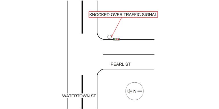
Address:
PEARL ST & WATERTOWN ST
Speed
limit:
25
Violation
cited:
no
Narrative:
On the above date and time I responded to the area of Watertown Street at Pearl St for a report of a traffic signal that was knocked down. Upon arrival on scene I observed the traffic signal knocked over and tire impressions of a possible sidewalk plow. I took pictures of the crash site area and will have them downloaded at the I.T. Bureau. I canvassed the area and found a City of Newton sidewalk plow with the operator. I spoke to the operator who stated he observed the damaged traffic signal and moved it out of the way but he did not have contact with it. I had dispatch notify the traffic signal company due the lights in the intersection being out. I also canvassed the area for cameras with negative results.
Keywords:
Crash, Pictures
Dcc:
Unknown
Report
url:
Image
url:
Latitude:
42.3614737
Longitude:
-71.1969079
Location:
Case
number:
Date:
2019-01-20
Time:
11:51
Address:
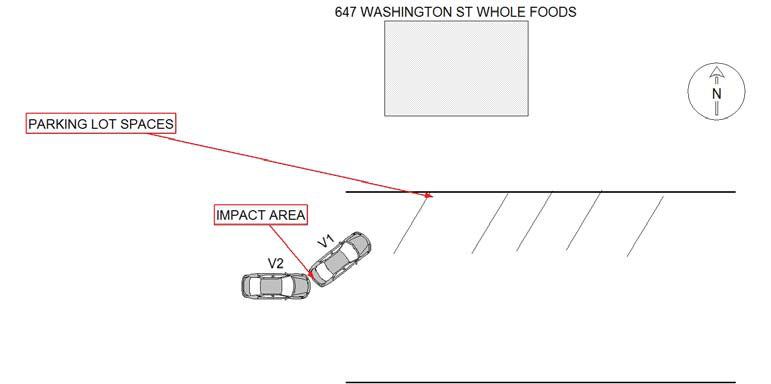
647 WASHINGTON ST
Speed
limit:
25
Violation
cited:
no
Narrative:
On the above date/time I responded to 647 Washington Street for a report of a two vehicle crash. Upon arrival I met with the operator of vehicle two Mr. Weiner, he stated he was stopped in the Whole foods parking lot when vehicle one backed up into his vehicle. They exchanged information but the operator of vehicle one Ms. Adetola left prior to my arrival. I obtained her license information through Mr. Weiner and when I ran the reg plate on vehicle one it came back to Watertown Ford. I advised Mr. Weiner of the process and I will contact Watertown Ford for more contact information on Ms. Adetola to obtain a statement. Update:Jan. 21, 2019 On Jan. 21, 2019 I contacted Watertown Ford advised them of the crash and obtained a phone number for the operator of vehicle one. I spoke to her on the phone she stated the parking lot roadway was covered in snow/ice, she was backing out of the parking spot and vehicle two continued traveling and struck her vehicle. I advised her of the process.
Keywords:
Crash, Phone, Snow
Dcc:
Unknown
Report
url:
Image
url:
Latitude:
42.3541087
Longitude:
-71.2000849
Location:
Advanced export
JSON shape: default, array, newline-delimited, object
CREATE TABLE "crash_reports" (
   [case_number] TEXT PRIMARY KEY,
   [datetime] TEXT,
   [date] TEXT,
   [time] TEXT,
   [address] INTEGER,
   [street1] TEXT,
   [street2] TEXT,
   [intersection] INTEGER,
   [speed_limit] INTEGER,
   [hit_run] INTEGER,
   [violation_cited] INTEGER,
   [narrative] TEXT,
   [keywords] TEXT,
   [dcc] TEXT,
   [dcc_code] TEXT,
   [report_url] TEXT,
   [image_url] TEXT
, [geocoded_address] TEXT, [latitude] TEXT, [longitude] TEXT, [manual_geocode] INTEGER, [retrieved] TEXT);