crash_reports
2 rows where "datetime" is on date 2021-05-19, dcc = "["Inattention"]" and intersection = 0
This data as json, CSV (advanced)
Suggested facets: datetime (date), date (date), retrieved (date), keywords (array), dcc (array)
Case
number:
Date:
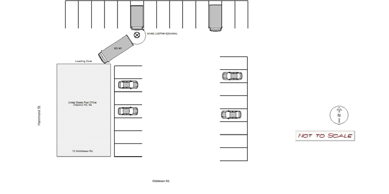
2021-05-19
Time:
07:22
Address:
12 MIDDLESEX RD
Speed
limit:
0
Violation
cited:
no
Narrative:
On 5/19/2021 at 0730 hrs, I responded to the parking lot of 12 Middlesex Rd. the United States Postal Office; Chestnut Hill. Postal Truck #9204484 (MV#2) was parked facing southbound in the rear parking lot across from the loading dock. MV#2 had front end damage and a broken head light. The operator of MV#1 (carrier truck) stated he had difficulty maneuvering as he was backing up the truck and collided into the front of MV#2. No damage was observed to MV#1. MV#2 was unoccupied at the time of the collision. No injuries were reported.
Keywords:
[]
Dcc:
Inattention
Report
url:
Image
url:
Latitude:
42.326314
Longitude:
-71.1649964
Location:
Case
number:
Date:
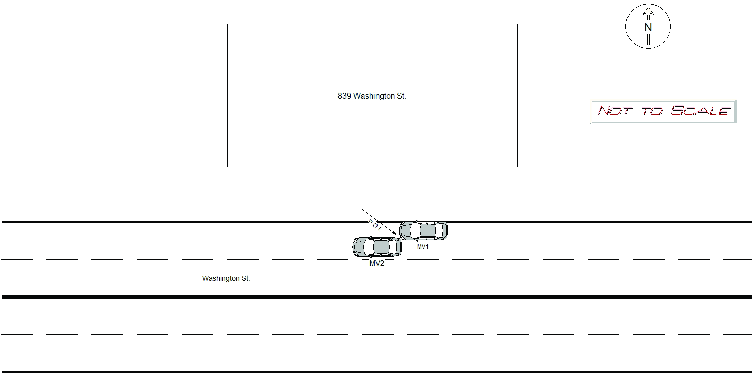
2021-05-19
Time:
14:28
Address:
839 WASHINGTON ST
Speed
limit:
25
Violation
cited:
yes
Narrative:
MV1 stated they were parked facing westbound outside of 839 Washington St. MV1 stated when they came out to their vehicle, they noticed the front driver side bumper was dented and the driver side door was scratched with white paint. The witness stated they were working in the area when they saw MV2 back into MV1 and take off. The witness was able to stop MV2 and get their plate number and phone number. The operator of MV2 was a female who stated she left the scene because she was "scared". Attempts to contact MV2 were made with negative results. I will be charging the owner of MV2 with MGL Ch. 90 s24 Leaving the scene of property damage.
Keywords:
Phone
Dcc:
Inattention
Report
url:
Image
url:
Latitude:
42.3517294
Longitude:
-71.2077427
Location:
Advanced export
JSON shape: default, array, newline-delimited, object
CREATE TABLE "crash_reports" (
   [case_number] TEXT PRIMARY KEY,
   [datetime] TEXT,
   [date] TEXT,
   [time] TEXT,
   [address] INTEGER,
   [street1] TEXT,
   [street2] TEXT,
   [intersection] INTEGER,
   [speed_limit] INTEGER,
   [hit_run] INTEGER,
   [violation_cited] INTEGER,
   [narrative] TEXT,
   [keywords] TEXT,
   [dcc] TEXT,
   [dcc_code] TEXT,
   [report_url] TEXT,
   [image_url] TEXT
, [geocoded_address] TEXT, [latitude] TEXT, [longitude] TEXT, [manual_geocode] INTEGER, [retrieved] TEXT);