crash_reports
5 rows where "datetime" is on date 2021-10-13 and intersection = 0
This data as json, CSV (advanced)
Suggested facets: hit_run, violation_cited, keywords, dcc, dcc_code, datetime (date), date (date), retrieved (date), keywords (array), dcc (array)
Case
number:
Date:
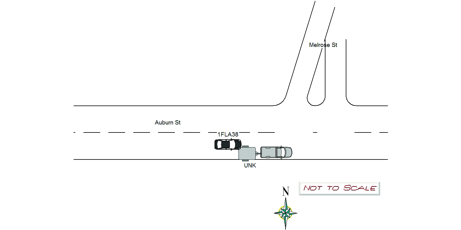
2021-10-13
Time:
08:03
Address:
349 AUBURN ST
Speed
limit:
25
Violation
cited:
yes
Narrative:
On 10/13/2021 at approx 0803Hrs while assigned to 497 I responded to the area of 349 Auburn St for a report of a two car crash with injury. Upon arrival I observed Ma Reg 1FLA38 disabled in the middle of the road with heavy front passenger side damage, with both front and passenger side airbags deployed. Fallon ambulance was on scene with the operator , John McHugh on the stretcher with a head injury. The Fallon EMT's Alex Honrado and Steve Hough stated they had been parked on Auburn St when McHugh ran into the back of a parked landscape trailer. I spoke with McHugh who stated he could not see out his windshield as he had just left his home on Bourne St and his windshield was not defrosted yet and ran into the trailer. McHugh and Fallon Ambulance personnel said as there had been no damage to the trailer the landscaper had left and nobody got a plate number or company name. McHugh transported to NWH, Todys towed the vehicle. A routine registry check showed McHugh has a suspended license.Ma Uniform Citation T2015320 for criminal application for violation of MGL Chec90 Sec 23 Operating After Suspension mailed to McHugh.
Keywords:
Airbag, Citation, Crash, Ems
Dcc:
Visibility obstructed
Report
url:
Image
url:
Latitude:
42.3465474
Longitude:
-71.2484546
Location:
Case
number:
Date:
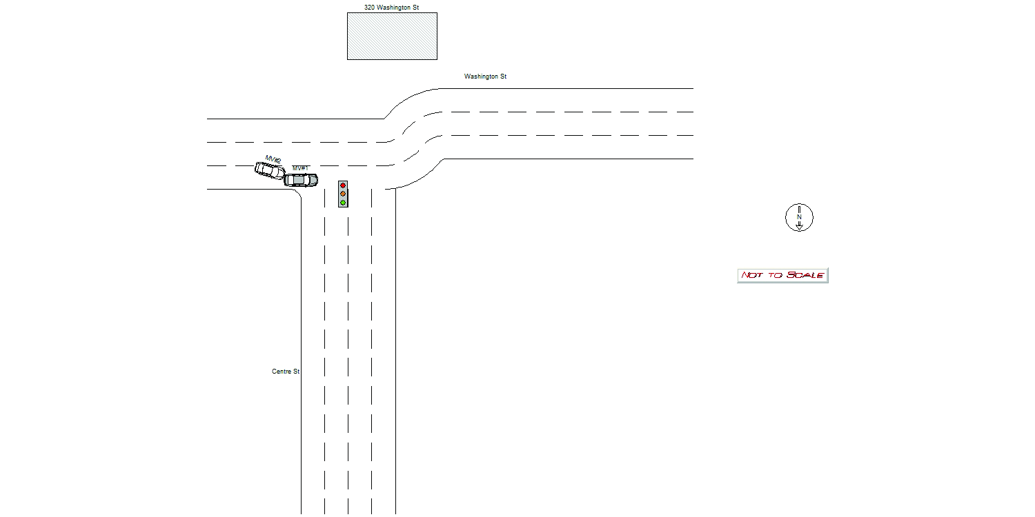
2021-10-13
Time:
09:10
Address:
320 WASHINGTON ST
Speed
limit:
25
Violation
cited:
no
Narrative:
Operator #1 stated he was travelling westbound on Washington St passing the Sheraton Four Points Hotel, 320 Washington St, when he was hit by another vehicle. Operator #1 stated the operator of a white sedan ( Operator #2) was attempting to change lanes behind him and hit the rear driver side of his vehicle. Operator #2 fled the area without stopping. Vehicle #1 had minor damage to the rear of his vehicle. He stated Vehicle #2 would have damage to the front of their vehicle but unsure what side. He stated Vehicle #2 was a white sedan with a black male driver and a person in the back seat, possibly a rideshare service. Operator #1 was able to drive his vehicle away from the scene.
Keywords:
[]
Dcc:
Lane departure, Inattention
Report
url:
Image
url:
Latitude:
42.3563932
Longitude:
-71.1872752
Location:
Case
number:
Date:
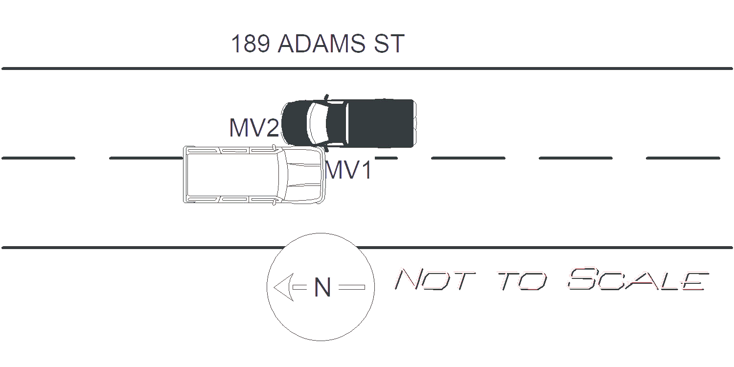
2021-10-13
Time:
14:48
Address:
189 ADAMS ST
Speed
limit:
25
Violation
cited:
no
Narrative:
OPERATOR OF MV1 STATED SHE WAS TRAVELING NORTH ON ADAMS ST WHEN MV2 (UNKNOWN REG PLATE) TRAVELING IN THE OPPOSITE DIRECTION CROSSED OVER THE DOUBLE YELLOW LINES AND STRUCK HER VEHICLE CAUSING DAMAGE TO HER DRIVERS SIDE MIRROR. MV2 WAS AN SUV WHITE IN COLOR AND THE OPERATOR WAS DESCRIBED AS A WHITE MALE WITH GRAY HAIR AND GLASSES POSSIBLY IN HIS 50'S OR 60'S. MV 2 DID NOT STOP TO EXCHANGE INFORMATION AND NO INJURIES WERE REPORTED.
Keywords:
[]
Dcc:
[]
Report
url:
Image
url:
Latitude:
42.358424
Longitude:
-71.2004413
Location:
Case
number:
Date:
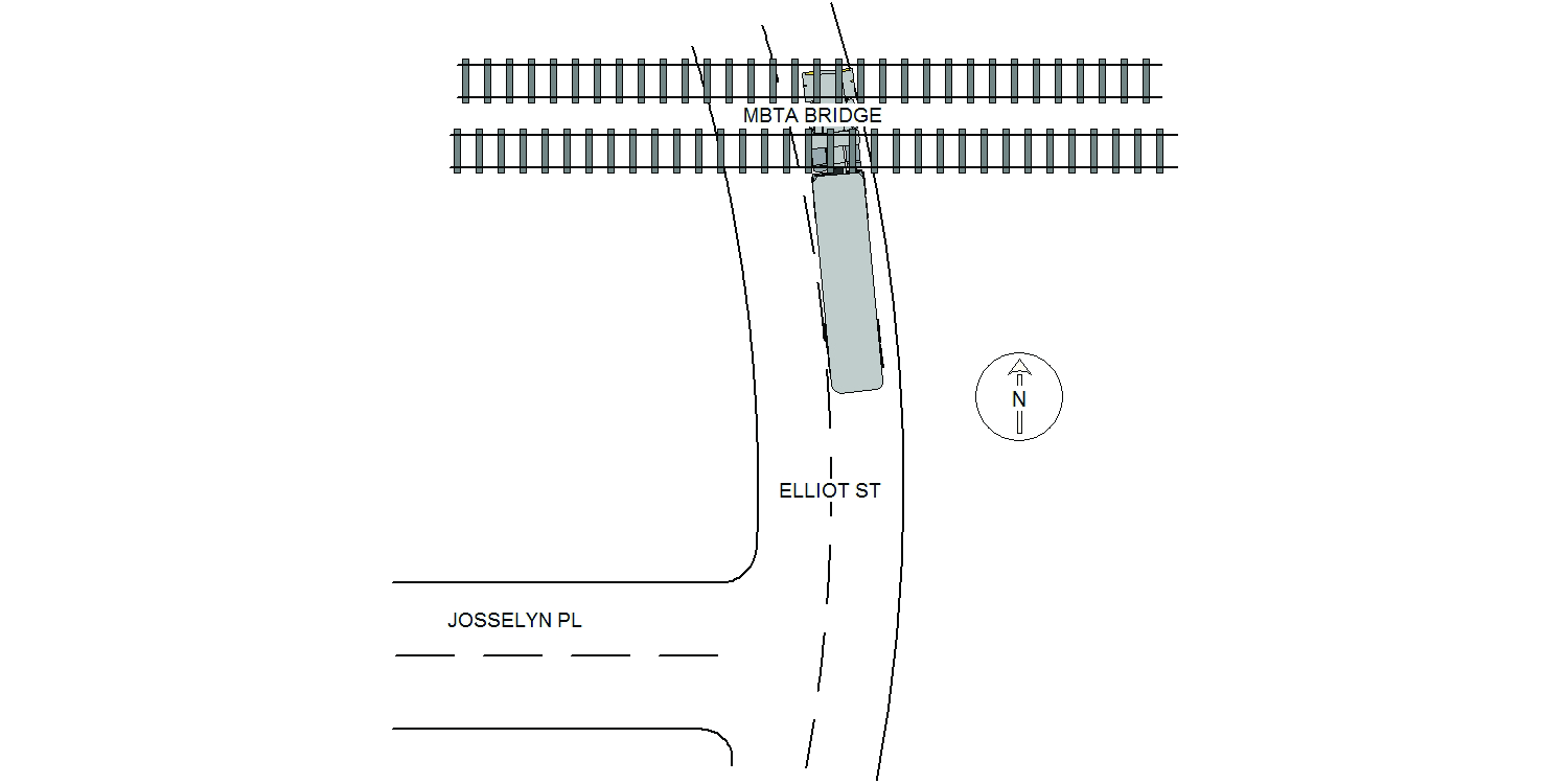
2021-10-13
Time:
15:23
Address:
24 ELLIOT ST
Speed
limit:
25
Violation
cited:
no
Narrative:
M/V #1 was traveling north on Elliot St. As it approached and attempted to pass under the MBTA bridge, the top of the trailer struck the underside of the bridge. It should be noted, that there are no signs of the bridge height, or max. allowable height facing north. The top left corner of the trailer was damaged. There was no visible damage to the bridge.
Keywords:
[]
Dcc:
Unknown
Report
url:
Image
url:
Latitude:
42.3179196
Longitude:
-71.2125693
Location:
Case
number:
Date:
2021-10-13
Time:
18:33
Address:
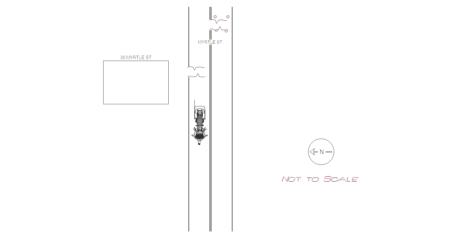
40 MYRTLE ST
Speed
limit:
25
Violation
cited:
no
Narrative:
On 10/13/2021 at 18:33 hours I responded to 30 Myrtle St for a report of a single vehicle crash involving a motorcycle that had a driver and a passenger. Myrtle St is a public way in the City of Newton. Upon my arrival I spoke with Roberto Ventura who stated that he and his passenger Melissa Mendoza were ridding westbound on Myrtle St on his 2009 Yamaha Raider motorcycle. Ventura and Mendoza were both wearing DOT approved helmets at the time of the crash. Ventura stated that as he approached 30 Myrtle St he drove over a patch of compacted dirt and gravel that was approximately three feet wide and four feet long. The patch was not coved by asphalt and was dug out and filled by the City of Newton Utilities Department. The patch of dirt and gravel was not marked by any cones, barrels or barricades. There were no street lights in the area so the roadway was not lit. There was a similar patch approximately 10 feet east that had four cones around it. Ventura stated that he did not see the dirt patch until he drove over it. Ventura stated that after driving over the dirt patch that he did not see at approximately 20 MPH he lost control of the motorcycle. Both Ventura and Mendoza stated that he were then thrown from the motorcycle and landed on the roadway. Ventura complained about pain in his left shoulder and knee, and had road rash abrasions to his left leg and arm. Mendoza stated that she had road rash abrasions to her left arm and leg. Both Ventura and Mendoza declined medical treatment at the crash scene and singed patient refusal forms provided to them by Fallon medic. Ventura's motorcycle had damage to it's left side tail light, and handlebar, as well as scrapes on the left side. Ventura's motorcycle did not require a tow. I placed reflective cones around the dirt and gravel patch and had dispatch leave a message for Newton Utilities to pave over both patches.
Keywords:
Crash, Helmet
Dcc:
[]
Report
url:
Image
url:
Latitude:
42.3437168
Longitude:
-71.2331515
Location:
Advanced export
JSON shape: default, array, newline-delimited, object
CREATE TABLE "crash_reports" (
   [case_number] TEXT PRIMARY KEY,
   [datetime] TEXT,
   [date] TEXT,
   [time] TEXT,
   [address] INTEGER,
   [street1] TEXT,
   [street2] TEXT,
   [intersection] INTEGER,
   [speed_limit] INTEGER,
   [hit_run] INTEGER,
   [violation_cited] INTEGER,
   [narrative] TEXT,
   [keywords] TEXT,
   [dcc] TEXT,
   [dcc_code] TEXT,
   [report_url] TEXT,
   [image_url] TEXT
, [geocoded_address] TEXT, [latitude] TEXT, [longitude] TEXT, [manual_geocode] INTEGER, [retrieved] TEXT);