crash_reports
2 rows where "datetime" is on date 2021-11-21, intersection = 0 and keywords contains "Speed"
This data as json, CSV (advanced)
Suggested facets: datetime (date), date (date), retrieved (date), keywords (array), dcc (array)
Case
number:
Date:
2021-11-21
Time:
07:56
Address:
573 CENTRE ST
Speed
limit:
30
Violation
cited:
yes
Narrative:
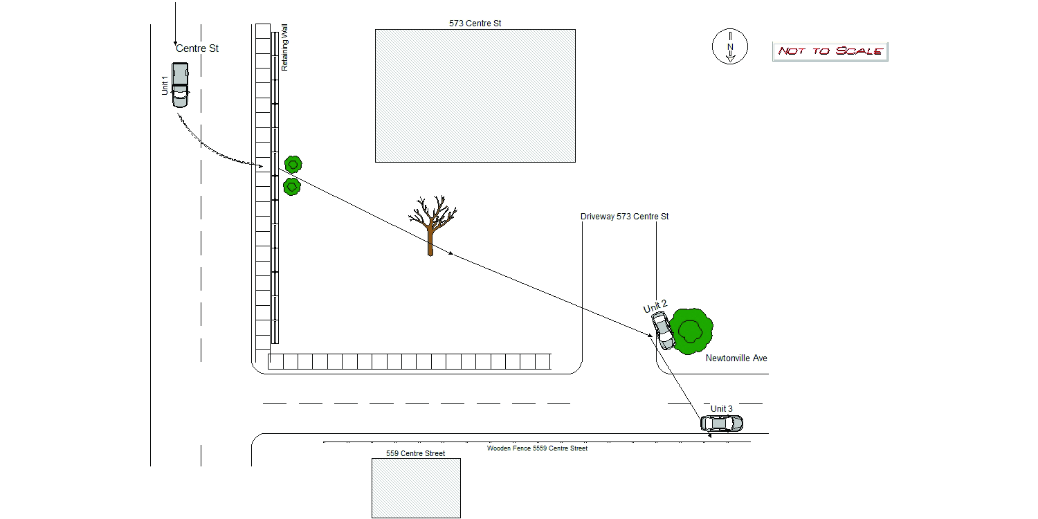
On November 21st, 2021 at approximately 07:56 hours while working N491 I along with Officer Mike Boudreau responded with NFD and Medic One to a report of a MV crash with injuries in the area of Centre St @ Franklin St. On my arrival the Medics were evaluating two adult males who standing outside one of the involved vehicle from this crash. There appeared to be several involved vehicles to this crash however two of them had been parked prior to the crash. The vehicle which the two unidentified males were standing by was MA reg. 9HY939, a 1988 Black Ford F150 PU, listed registered owner was a Peter J. Jara-Castro, #28 Ridge Ave, Lynn Ma. Mr Castro was one of the two males standing by that truck. The above vehicle appeared to have been travelling N/B on Centre St when it skidded off the road, jumping the curb striking a 1 foot slate retaining wall to the property to #573 Centre St. It continued onto that property driving over shrubs, small trees, then onto the driveway(same address) which is actually on Newtonville Ave, hitting the homeowners 2007 Nissan Versa, Ma reg. 6BH269, forcing it into more shrubbery. The Truck continued across Newtonville Ave where it struck another parked vehicle, a Grey 2019 Volkswagon, Ma reg. 1NFC27 on the rear passenger side pushing it forward. The truck finally came to a stop after driving into a wooden fence to the property of #559 Centre St.(Fence is on Newtonville Ave.) I spoke with the owner of the truck after he was evaluated by the Medics, who spoke limited English. The owner of the truck Peter Jara-Castro finally said he was driving the truck prior to the crash. His statement was he was travelling N/B down Centre St when another vehicle came out from Newtonville Ave causing him to slam on his brakes. Mr Castro doesn't remember much after that, possibly from hitting his head. At this time I couldn't determine who the actual driver was. Both Mr Castro and the passenger, sustained injuries but both declined to go to the hospital. Both were later picked up by an UBER driver. A Firefighter heading to work reported seeing the truck pass him on Centre St N/B at high rate of speed but never saw the driver or the actual crash. Both property owners that sustained damage were given Trucks insurance info. Pictures were taken by both property owners. Vehicle #1 and vehicle #2 were towed from scene. Both sustained heavy damage. Vehicle #3 sustained minor damage I was unable to make contact with that owner at this time. However later in the day I was able to make contact with owner of vehicle #3. She was given all vehicle #1 information along with his insurance. A citation for speeding was later issued after investigation was completed and witness statement. Citation#t1444076 was later sent VIA mail.
Keywords:
Citation, Crash, Fire, Hospital, Pictures, Speed, Tree
Dcc:
Reckless driving
Report
url:
Image
url:
Latitude:
42.351427
Longitude:
-71.1862931
Location:
Case
number:
Date:
2021-11-21
Time:
17:20
Address:
191 JACKSON RD
Speed
limit:
25
Violation
cited:
yes
Narrative:
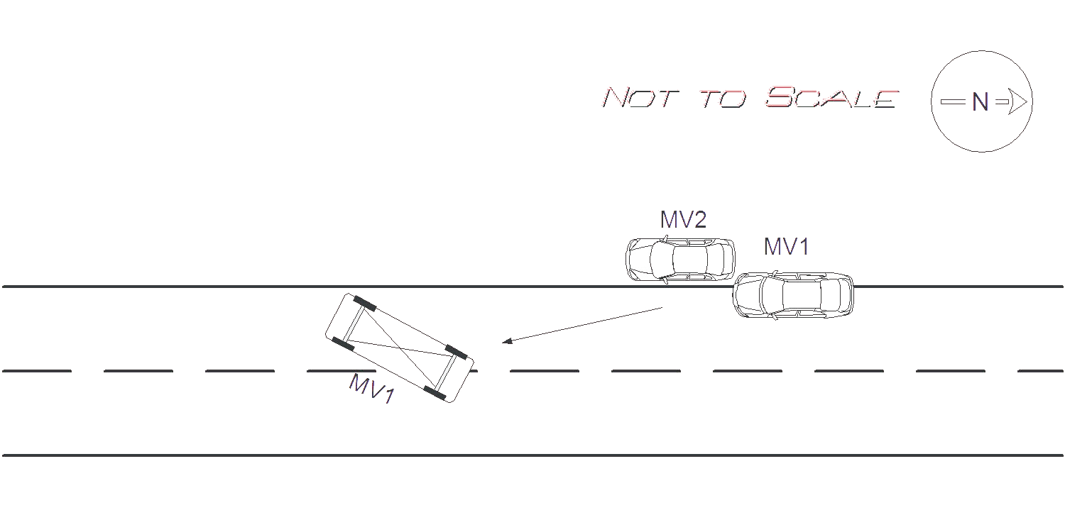
On Sunday November 21st at approx. 1720 Hrs. I responded to 191 Jackson Rd for a motor vehicle accident roll over with entrapment. Upon arrival I witnessed MV1 on its side in the middle of Jackson Rd. The operator of MV1 was conscious and alert and was taken out of the MV by the Newton Fire Department. The operator of MV1 stated that she was driving S/B on Jackson Rd. and she did not see the parked car on the right side of the road. MV1 then tried to swerve around MV2 and clipped the left rear bumper, and left rear door of MV2 which caused MV1 to roll over onto the middle of the road. MV1 had major damage all around the vehicle and all airbags deployed. MV2 had major damage to the rear and to the left side of the MV. Due to the extensive damage and length of travel of MV1 it was estimated that MV1 was traveling at a speed greater than 35 MPH. Speed limit for Jackson Rd is 25 MPH. MV2 was pushed approx. 20 feet from where it was parked, and MV1 travelled approx 25 feet after on its drivers side after impact. The operator of MV1 was transported by EMS to NWH, and Todys's took possession of both motor vehicles. Pictures were taken and submitted to IT. The operator of MV1 was cited 90/17, speeding.
Keywords:
Airbag, Citation, Crash, Ems, Fire, Pictures, Severe, Solar, Speed
Dcc:
Speeding
Report
url:
Image
url:
Latitude:
42.3564835
Longitude:
-71.195531
Location:
Advanced export
JSON shape: default, array, newline-delimited, object
CREATE TABLE "crash_reports" (
   [case_number] TEXT PRIMARY KEY,
   [datetime] TEXT,
   [date] TEXT,
   [time] TEXT,
   [address] INTEGER,
   [street1] TEXT,
   [street2] TEXT,
   [intersection] INTEGER,
   [speed_limit] INTEGER,
   [hit_run] INTEGER,
   [violation_cited] INTEGER,
   [narrative] TEXT,
   [keywords] TEXT,
   [dcc] TEXT,
   [dcc_code] TEXT,
   [report_url] TEXT,
   [image_url] TEXT
, [geocoded_address] TEXT, [latitude] TEXT, [longitude] TEXT, [manual_geocode] INTEGER, [retrieved] TEXT);