crash_reports
3 rows where "datetime" is on date 2022-01-07 and keywords contains "Crash"
This data as json, CSV (advanced)
Suggested facets: intersection, speed_limit, hit_run, violation_cited, datetime (date), date (date), retrieved (date), keywords (array), dcc (array)
Case
number:
Date:
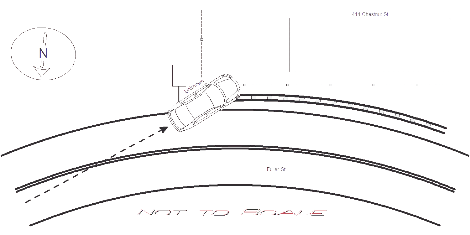
2022-01-07
Time:
12:51
Address:
414 CHESTNUT ST
Speed
limit:
20
Violation
cited:
no
Narrative:
Unknown vehicle was travelling on Fuller St W/B at #80 Fuller St where the road bends to the right approaching Chestnut St. Based on snowy road conditions, unknown vehicle failed to negotiate bend in road and slid off road to the left. Unknown vehicle bounced off guard rail, hit a right arrow street sign and crashed through the fence belonging to the resident of 414 Chestnut St. Unknown vehicle left the scene and remains unknown. Based on snow accumulation, it appeared crash occurred several hours prior to my arrival. 414 Chestnut St homeowner and other neighbors had no information to provide at this time. The homeowner will contact NPD if any useful video becomes available. City was notified to address the hit right arrow street sign.
Keywords:
Crash, Snow
Dcc:
Unknown
Report
url:
Image
url:
Latitude:
42.3352766
Longitude:
-71.2234522
Location:
Case
number:
Date:
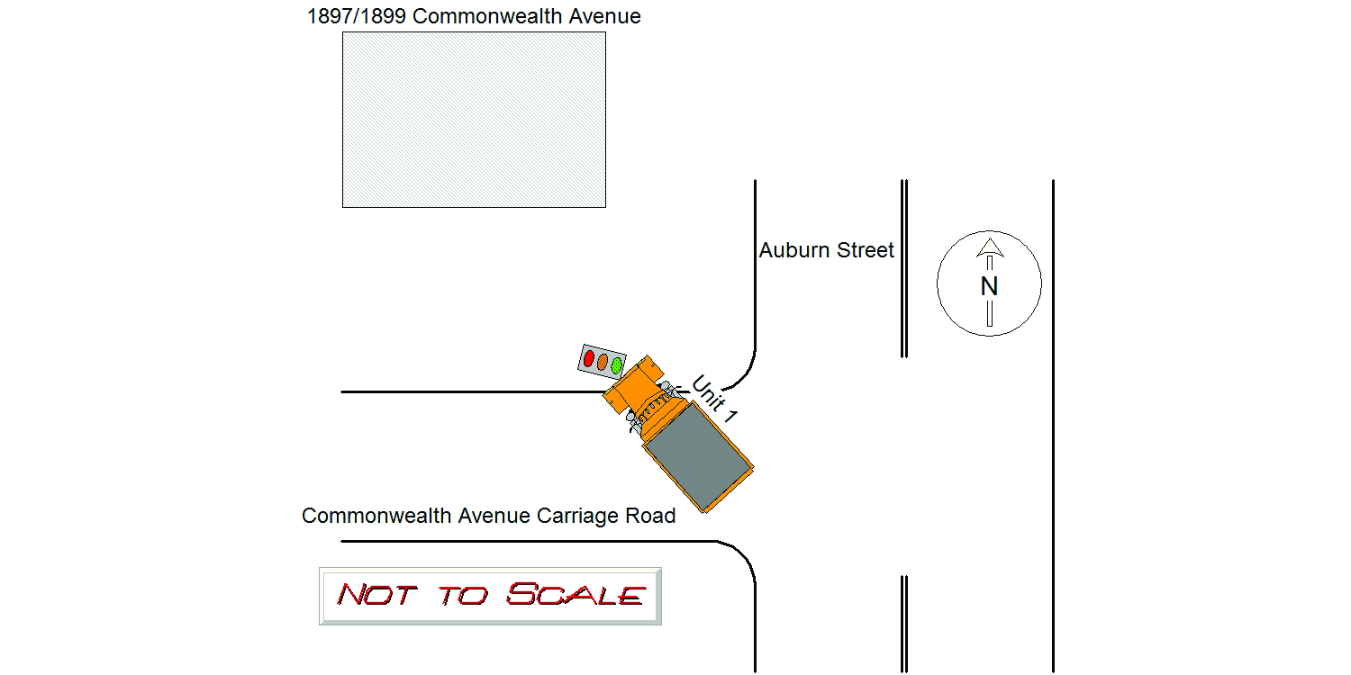
2022-01-07
Time:
12:21
Address:
1897 COMMONWEALTH AVENUE
Speed
limit:
25
Violation
cited:
no
Narrative:
On Friday, January 7, 2022, while assigned to Traffic unit N525, I responded to the area of Commonwealth Avenue and Auburn Street, Newton for a report of a City of Newton plow truck that knocked over a traffic signal and left the area. The weather at the time of the crash was overcast and snow. The road surface was wet. Commonwealth Avenue and Auburn Street are both public ways maintained by the City of Newton. On arrival to this area, I observed a traffic signal resting on the sidewalk in front of 1897 Commonwealth Avenue. The traffic signal was cracked at it's base, and still functioning while resting on the sidewalk. The traffic signal when operation faces traffic traveling Westbound on the Commonwealth Avenue carriage road at Auburn Street. An anonymous resident of the area approached me and showed me a picture on their phone of the truck that left the area after crashing into the traffic signal. The photo was of a large City of Newton orange dump truck with a plow affixed to the front of it. I could not make out the registration of the vehicle, but I could see the number 48 on it's side to identify it. I requested Newton Dispatch contact the DPW to identify who the operator of the vehicle was. A message was left for Mr. Perry Cacciola (Newton DPW) for information about the crash. On Monday, January 10, 2021, I spoke with Mr. Cacciola. Mr. Cacciola stated Donald Leblanc (S00405419) was the operator of the plow responsible for the damage to the traffic signal. Mr. Cacciola stated he could not provide any information about the vehicle used in the crash, except that it was number 48. I then spoke with Mr. Leblanc. Mr. Leblanc stated he was operating the City of Newton plow involved in the crash. Mr. Leblanc stated the snow at the time of the crash was packed down and the plow made contact with the traffic signal while he was clearing the snow in front of 1897 Commonwealth Avenue. Mr. Leblanc stated he contacted his supervisor, Perry Cacciola, sometime after the the incident to reprot the damage. Mr. Leblanc reported no injuries. Photos were taken of the damaged traffic signal and submitted to the IT Bureau.
Keywords:
Crash, Phone, Pictures, Snow
Dcc:
Inattention
Report
url:
Image
url:
Latitude:
42.3448904
Longitude:
-71.2405302
Location:
Case
number:
Date:
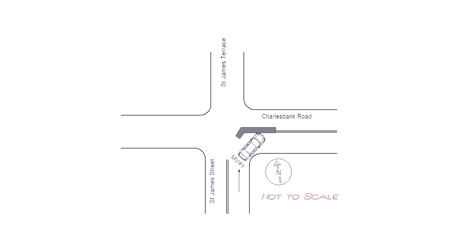
2022-01-07
Time:
06:12
Address:
CHARLESBANK RD & ST JAMES ST
Speed
limit:
25
Violation
cited:
yes
Narrative:
The OP. of MV#1 doesn't speak English and had to have a coworker help translate. The OP of MV#1 stated he was travelling on St. James Street northbound slowly because of the snowstorm. He made a slow right turn onto Charlesbank Road but his vehicle slid and crashed into the median in the roadway. The OP. of MV#1 stated he was the vehicle owner and didn't have a valid U.S. driver's license. He couldn't provide any identification and only a picture of his passport on his phone. Due to the narrow roadway and traffic getting backed up from two accidents, the OP. of MV#1 was sent on his way (coworkers picked him up) and advised he will be mailed a citation for being unclicensed.
Keywords:
Citation, Crash, Phone, Pictures, Snow
Dcc:
[]
Report
url:
Image
url:
Latitude:
42.3587668
Longitude:
-71.1802241
Location:
Advanced export
JSON shape: default, array, newline-delimited, object
CREATE TABLE "crash_reports" (
   [case_number] TEXT PRIMARY KEY,
   [datetime] TEXT,
   [date] TEXT,
   [time] TEXT,
   [address] INTEGER,
   [street1] TEXT,
   [street2] TEXT,
   [intersection] INTEGER,
   [speed_limit] INTEGER,
   [hit_run] INTEGER,
   [violation_cited] INTEGER,
   [narrative] TEXT,
   [keywords] TEXT,
   [dcc] TEXT,
   [dcc_code] TEXT,
   [report_url] TEXT,
   [image_url] TEXT
, [geocoded_address] TEXT, [latitude] TEXT, [longitude] TEXT, [manual_geocode] INTEGER, [retrieved] TEXT);