crash_reports
8 rows where dcc = "["Over-steering"]", intersection = 0 and keywords contains "Pictures"
This data as json, CSV (advanced)
Suggested facets: speed_limit, hit_run, dcc_code, datetime (date), date (date), retrieved (date), keywords (array), dcc (array)
Case
number:
Date:
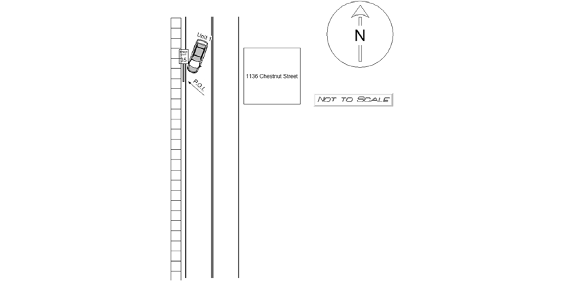
2019-01-13
Time:
17:55
Address:
1136 CHESTNUT ST
Speed
limit:
25
Violation
cited:
no
Narrative:
The operator of MV1 stated that she was traveling southbound on Chestnut street when she lost control of her vehicle causing the vehicle to jump the curb and run over a city speed limit sign breaking it at the base. The city was notified of the broken sign and pictures were taken and placed in ITs mailbox to be attached to the report. The vehicle sustained a right rear flat tire and was towed by AAA. All parties reported no injuries and signed a patient refusal.
Keywords:
Pictures, Speed
Dcc:
Over-steering
Report
url:
Image
url:
Latitude:
42.3103168
Longitude:
-71.2238119
Location:
Case
number:
Date:
2019-10-04
Time:
22:47
Address:
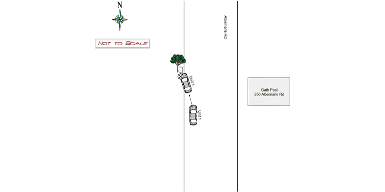
256 ALBEMARLE RD
Speed
limit:
25
Violation
cited:
no
Narrative:
MV1 (MA Reg:2LM951; 2016 Ford Fusion) was traveling NORTH when it ran off the road hitting the median curb, then a "No Parking This Side" sign, then a tree on the Albemarle Rd median. MV1 operator, Cynthia Muzaki, stated that she saw something run across the road, swerved and collided with a pole then tree. Air bag deployment from the driver and passenger side deployed. Cynthia signed a refusal with the medics. Tody's towed the vehicle. Cynthia ordered an Uber back to her residence in Watertown. DPW notified about the sign that was damaged. Pictures of the scene were sent to IT.
Keywords:
Pictures, Tree
Dcc:
Over-steering
Report
url:
Image
url:
Latitude:
42.3576147
Longitude:
-71.2159572
Location:
Case
number:
Date:
2020-12-02
Time:
09:54
Address:
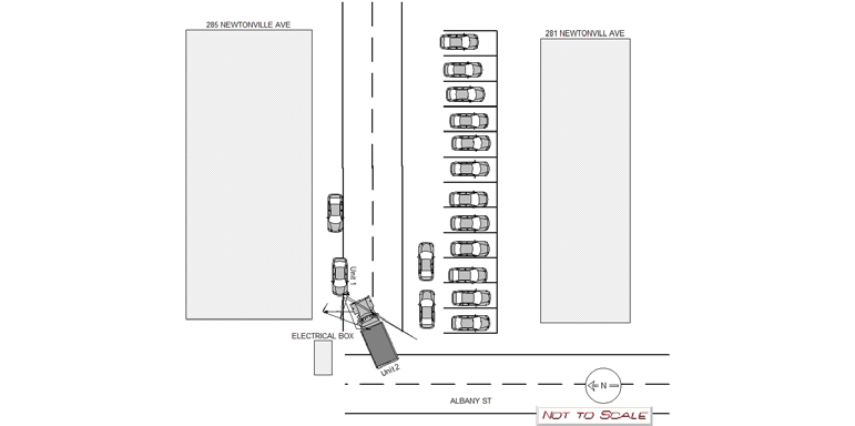
285 NEWTONVILLE AVE
Speed
limit:
25
Violation
cited:
no
Narrative:
Operator of vehicle #1 City of Newton DPW employee Daniel Saulnier stated that on 12/02/2020 at 09:54 hours he was driving a City of Newton dump truck ( 2015 Frightliner MA reg MVN M9224 ) on Albany St near the driveway the runs between 281 Newtonville Ave and 285 Newtonville Ave. Saulnier stated that there were cars parked horizontally at the rear of 281 Newtonville Ave as well as two cars that were parked vertically behind the horizontal parked cars. Saulnier also stated that there was an electrical box at the north west corner of 285 Newtonville Ave. Saulnier stated that vehicle #2 ( MA par reg K5245 2017 BMW SUV ) was parked unoccupied facing east. Saulnier stated that due to the congestion caused by the vertically parked cars and the electrical box, the front driver's side of his truck's bumper made contact with the rear passenger side of vehicle two. Vehicle #1 had small scuff marks on it's driver's side front bumper. Vehicle #2 had scrapes to it's rear passenger side . Saulnier stated that he was not injured in the crash and neither vehicle required a tow. I took photos of both vehicles and had the disk downloaded by the NPD'S IT bureau.
Keywords:
Crash, Pictures
Dcc:
Over-steering
Report
url:
Image
url:
Latitude:
42.3530962
Longitude:
-71.1986533
Location:
Case
number:
Date:
2021-01-22
Time:
08:17
Address:
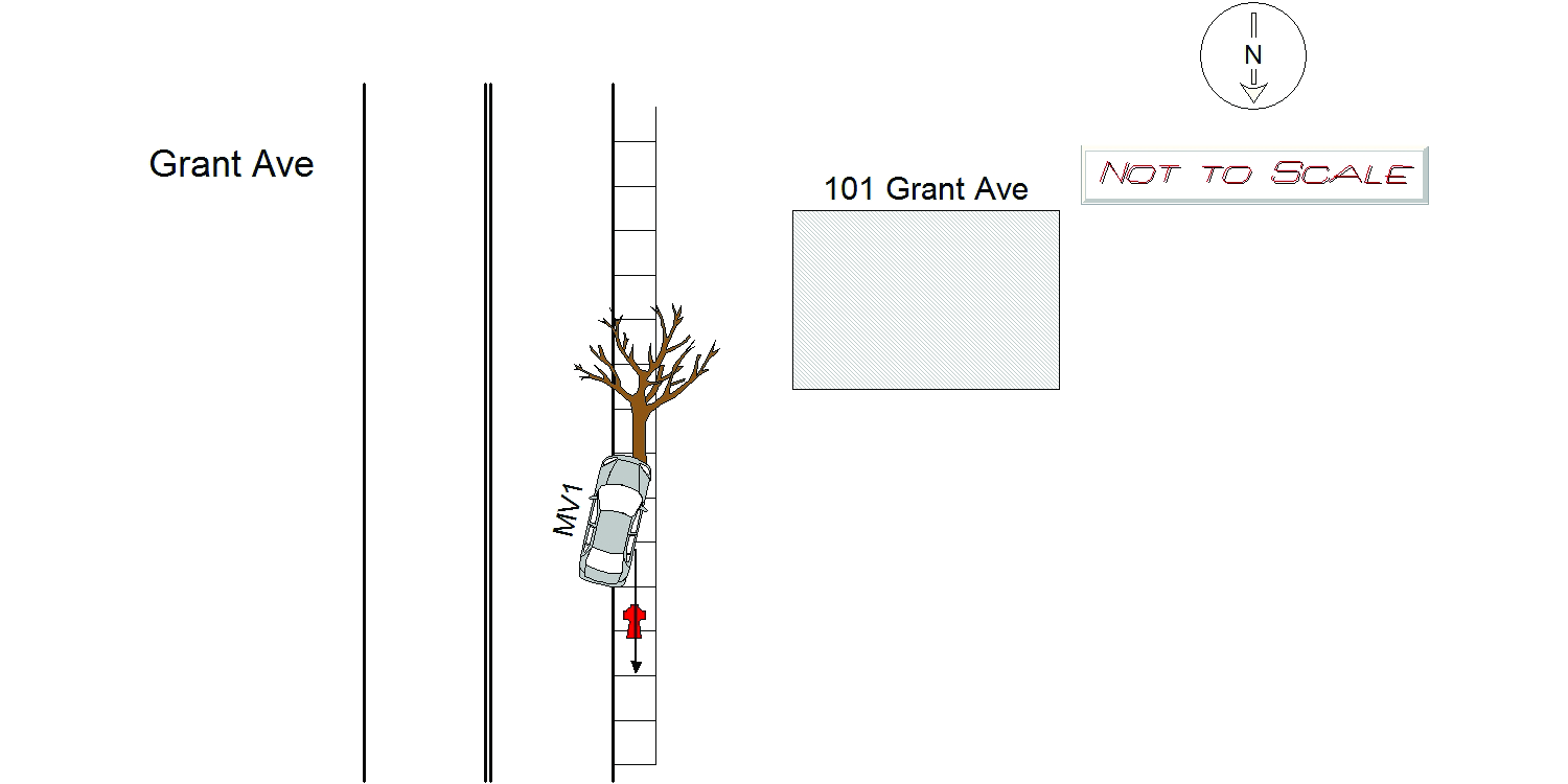
101 GRANT AVE
Speed
limit:
25
Violation
cited:
no
Narrative:
On January 22, 2021 at approximately 08:17 hours I responded to a single motor vehicle crash in the area of Commonwealth Ave at Grant Ave. It was reported that a motor vehicle struck a tree and a fire hydrant. Upon arrival I spoke with MV1, who said that she was traveling southbound on Grant Ave when she saw a vehicle traveling northbound traveling close to the solid double line. MV 1 got nervous and swerved to the right causing her to jump the curb and strike a city tree. MV1 then reversed into a fire hydrant, causing it to become dislodged. Traffic Officer Ciccone responded and took pictures of the damages and Tody's removed the vehicle from the scene.
Keywords:
Crash, Fire, Pictures, Tree
Dcc:
Over-steering
Report
url:
Image
url:
Latitude:
42.3360899
Longitude:
-71.1863701
Location:
Case
number:
Date:
2021-07-03
Time:
13:51
Address:
300 NEEDHAM ST
Speed
limit:
10
Violation
cited:
no
Narrative:
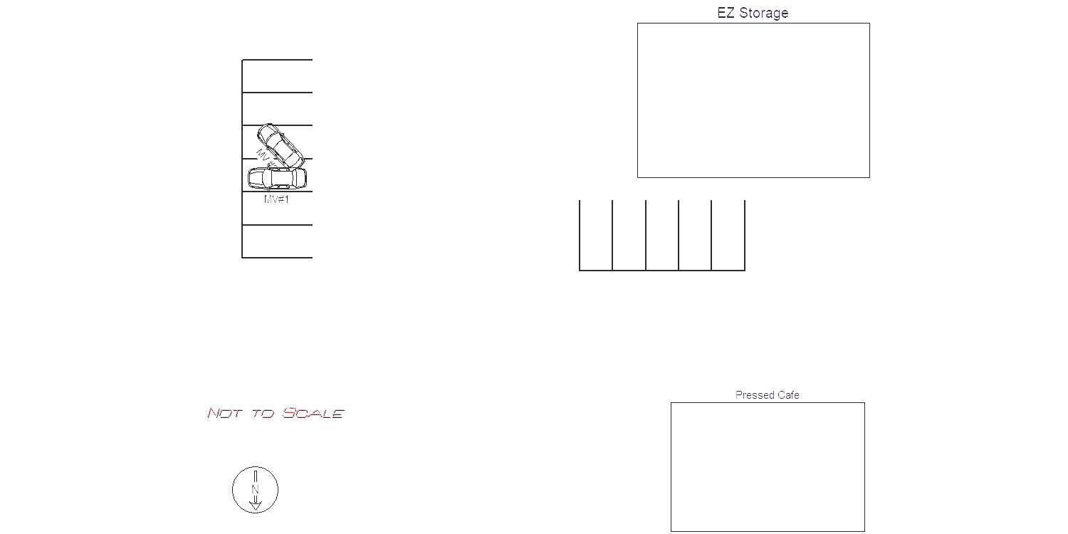
Witnesses #1 and #2 (anonymous) stated that Vehicle #1 was parked in a parking space behind Pressed Cafe. Vehicle #2 was parked to the right of Vehicle #1. Vehicle #2 attempted to back up out of their space, overcorrected, and backed into Vehicle #1. Witnesses stated Vehicle #2 drove away at a high rate of speed. Vehicle #1 suffered minor damage to the right rear side of the vehicle. Unknown damage to Vehicle #2. Witnesses followed the vehicle and provided me with a picture of the license plate. They were unable to describe the driver. I was able to locate the owner of Vehicle #1 and notify him of the damage. I responded to the address listed for Vehicle #2 with negative results. Report forwarded to Traffic Bureau for follow up with Vehicle #2. Traffic Bureau update (Officer Gaudet): On Tuesday, July 6, 2021, I made contact with the registered owner of MV2, Ms. Irina Mazo via telephone. Ms. Mazo stated she was away for the weekend but her daughter, Olga Rapoport, had the vehicle. I apprised Ms. Mazo about the crash involving her vehicle. Ms. Mazo stated she would contact her daughter and have her call me. A short time later, I received a call from Ms. Rapoport. Ms. Rapoport stated she was operating MA: 4LD211 at the time of the reported crash. Ms. Rapoport stated her rear passenger side bumber area crashed into MV1 as she was backing out of a parking spot. Ms. Rapoport stated she left the area with out stopping to assess the damage to MV1, or to attempt to make contact with the owner of MV1. I asked Ms. Rapoport why she did not stop. Ms. Rapoport stated she did not have an excuse. Ms. Rapoport stated there is no damage to her vehicle. Ms. Rapoport was advised and will be mailed Massachusetts Uniform Citation (061166AB) for Chapter 90, Section 24 (Leaving the Scene of Property Damage).
Keywords:
Citation, Crash, Pictures, Speed
Dcc:
Over-steering
Report
url:
Image
url:
Latitude:
42.3077228
Longitude:
-71.2144721
Location:
Case
number:
Date:
2022-03-01
Time:
10:35
Address:
308 HOMER
Speed
limit:
25
Violation
cited:
no
Narrative:
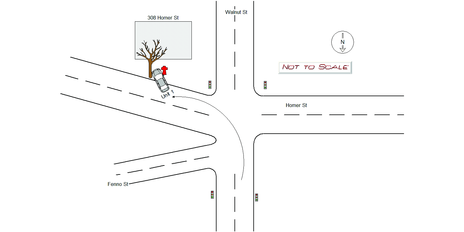
oper stated he was turning from Walnut St to Homer Street when his coffee spilled and lost control driving up the snow bank at 308 Homer Street. Vehicle also caused minor damage to city tree. When vehicle was towed away there was a fire hydrant that had been knocked out of place. No Injuries. Vehicle was towed by Tody's City notified about fire hydrant. Photos taken by traffic Officer Gaudet.
Keywords:
Fire, Pictures, Snow, Tree
Dcc:
Over-steering
Report
url:
Image
url:
Latitude:
42.3358364
Longitude:
-71.2067912
Location:
Case
number:
Date:
2022-06-21
Time:
08:05
Address:
12 MARSHFIELD RD
Speed
limit:
25
Violation
cited:
no
Narrative:
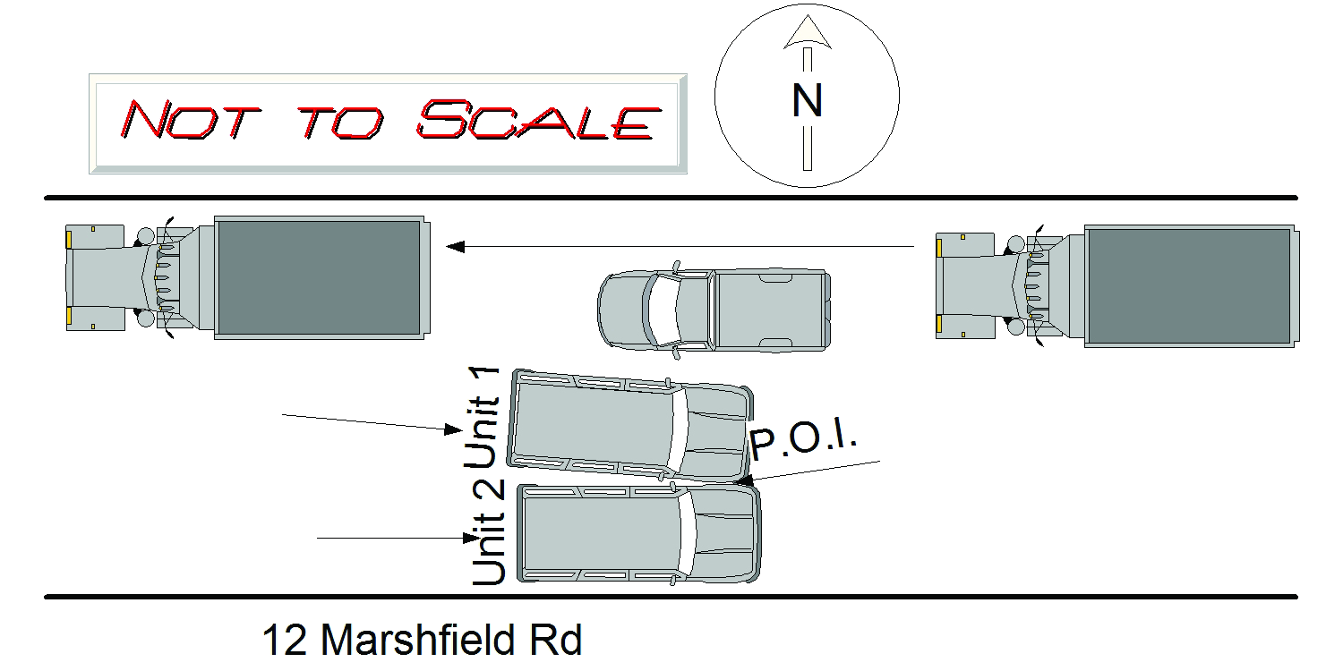
On 06/21/22 at 08:05 hours, I responded to 12 Marshfield Road for a City of Newton Dept. of Public Works vehicle involved in a crash with another vehicle. Marshfield Road is a public way maintained and owned by the City of Newton. At the time of the crash, the weather was sunny and clear and the road conditions were dry. Also, there was road construction going on as a company was grinding the roadways in the area for the City of Newton. Two detail officers were on scene and Ofc. Conary called in the accident to Newton Police Dispatch. On arrival, I spoke to the operator of M/V# 1 identified as Suzanne Ennis (MA D/L # S80758886) who was driving a 2015 Honda CRV color red bearing MA reg.# 769YR1. Ms. Ennis stated that due to the road construction and it being blocked at Walter Street and Jackson Street everyone was being funneled down (EB ) on Marshfield Rd by the detail officers. Ennis further stated that there was construction vehicle apparatus parked along Marshfield Road in the westbound direction which made the road narrow. She then attempted to pass a parked City of Newton Toyota Rav4 (M/V # 2) on the right of her when another pick up truck suddenly started traveling westbound. She says that she tried correcting her steering but made contact with the driver's side front quarter panel area of M/V # 2. I observed a minor black scuff mark to the front passenger side quarter panel area. M/V # 2 is a 2019 Toyota Rav4 color white bearing MA Official reg. # M5181A. It is owned by Enterprise FM Trust and being leased by the City of Newton Public Works. The Rav4 was parked legally on the right side near 12 Marshfield Road with a City of Newton employee sitting in the front driver's seat. The employee was Kimberly Ritcey who works for the engineering department for the Newton Dept. of Public Works. Ritcey reported no injuries. I observed minor scrape marks to the driver's side front quarter panel area. Photos taken of the scene and submitted to the I.T. Bureau.
Keywords:
Crash, Pictures, Solar
Dcc:
Over-steering
Report
url:
Image
url:
Latitude:
42.3204429
Longitude:
-71.1913827
Location:
Case
number:
Date:
2022-07-06
Time:
19:18
Address:
1243 WALNUT ST
Speed
limit:
25
Violation
cited:
no
Narrative:
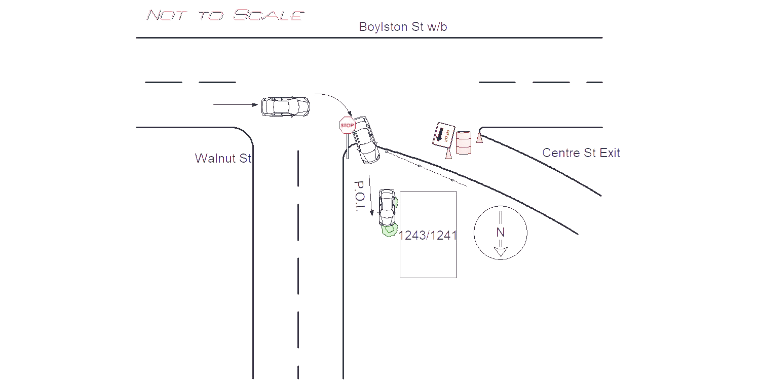
OP1 of MV1 was traveling westbound on Rt. 9. MV1 was headed toward the Centre Street exit of RT. 9. The Centre Street exit on Rt. 9 has been closed due to ongoing construction. MV1 did not realize the exit was closed. In an attempt to avoid driving through the detour signs, MV1 made an abrupt turn off of Rt. 9 onto Walnut Street. As MV1 abruptly turned onto Walnut Street (Northbound), OP1 had no control over MV1. MV1 continued onto the curb, through the grass, and through the drive away. MV1 then crashed into the front porch of 1243 Walnut Street. MV1 sustained heavy front end damage. MV1 was towed by Todys. A towed inventory sheet was completed. OP1 was transported to BI Boston by Fallon Ambulance. Dispatch notified Building Inspector. Photos of Crash were taken and turned into IT.
Keywords:
Crash, Ems, Pictures
Dcc:
Over-steering
Report
url:
Image
url:
Latitude:
Longitude:
Location:
Advanced export
JSON shape: default, array, newline-delimited, object
CREATE TABLE "crash_reports" (
   [case_number] TEXT PRIMARY KEY,
   [datetime] TEXT,
   [date] TEXT,
   [time] TEXT,
   [address] INTEGER,
   [street1] TEXT,
   [street2] TEXT,
   [intersection] INTEGER,
   [speed_limit] INTEGER,
   [hit_run] INTEGER,
   [violation_cited] INTEGER,
   [narrative] TEXT,
   [keywords] TEXT,
   [dcc] TEXT,
   [dcc_code] TEXT,
   [report_url] TEXT,
   [image_url] TEXT
, [geocoded_address] TEXT, [latitude] TEXT, [longitude] TEXT, [manual_geocode] INTEGER, [retrieved] TEXT);