crash_reports
2 rows where dcc = "["Speeding"]", intersection = 0 and keywords contains "Crash"
This data as json, CSV (advanced)
Suggested facets: datetime (date), date (date), retrieved (date), keywords (array), dcc (array)
Case
number:
Date:
2021-05-12
Time:
21:14
Address:
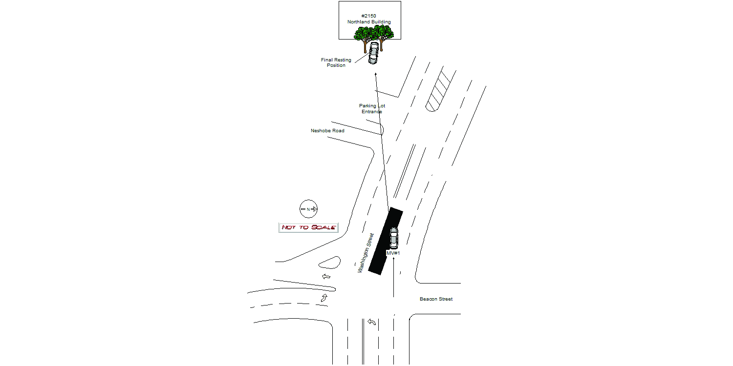
2150 WASHINGTON ST
Speed
limit:
25
Violation
cited:
yes
Narrative:
The OP. of MV#1 stated while traveling westbound on Washington Street, just passing Beacon Street, his vehicle suddenly struck a curb and he lost control of the vehicle. He ended up on the lawn of the Northland Building at 2150 Washington Street. Based on the accident scene, its appears that MV#1 went over the median on Washington Street, took down a city sign, hit the corner of Neshobe Road and the driveway into 2150 Washington Street which formed a ramp that launched his vehicle into the air. MV#1 spun around somehow and was now facing eastbound before the rear of the vehicle was wedged between a tree and a mound of dirt. Final resting position of MV#1 is approx. 250 feet from the median first struck. The operator of MV1 was transported to Newton-Wellesley Hospital for a head laceration and other unknown injures. Vehicle was towed from the scene by todys with major damage all over the vehicle. After reviewing surveillance video, the OP. of MV#1 was mailed MA. citation #T2014846 for violation of MGL Ch 89 Sec 4A - "Marked lanes violation" and Ch 90 Sec 17 - "Speed greater than reasonable."
Keywords:
Citation, Crash, Hospital, Tree
Dcc:
Speeding
Report
url:
Image
url:
Latitude:
42.3291503
Longitude:
-71.2501096
Location:
Case
number:
Date:
2021-11-21
Time:
17:20
Address:
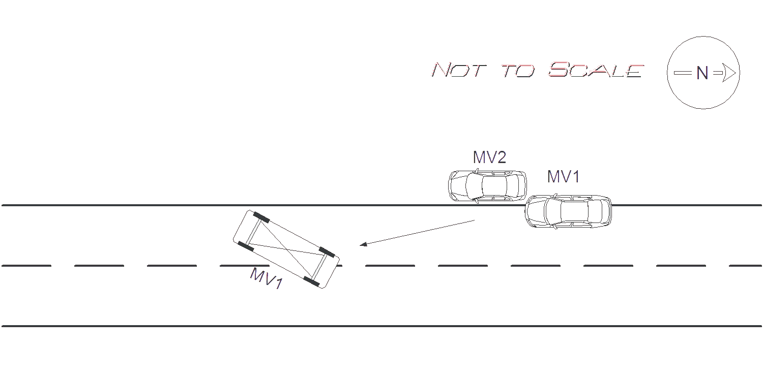
191 JACKSON RD
Speed
limit:
25
Violation
cited:
yes
Narrative:
On Sunday November 21st at approx. 1720 Hrs. I responded to 191 Jackson Rd for a motor vehicle accident roll over with entrapment. Upon arrival I witnessed MV1 on its side in the middle of Jackson Rd. The operator of MV1 was conscious and alert and was taken out of the MV by the Newton Fire Department. The operator of MV1 stated that she was driving S/B on Jackson Rd. and she did not see the parked car on the right side of the road. MV1 then tried to swerve around MV2 and clipped the left rear bumper, and left rear door of MV2 which caused MV1 to roll over onto the middle of the road. MV1 had major damage all around the vehicle and all airbags deployed. MV2 had major damage to the rear and to the left side of the MV. Due to the extensive damage and length of travel of MV1 it was estimated that MV1 was traveling at a speed greater than 35 MPH. Speed limit for Jackson Rd is 25 MPH. MV2 was pushed approx. 20 feet from where it was parked, and MV1 travelled approx 25 feet after on its drivers side after impact. The operator of MV1 was transported by EMS to NWH, and Todys's took possession of both motor vehicles. Pictures were taken and submitted to IT. The operator of MV1 was cited 90/17, speeding.
Keywords:
Airbag, Citation, Crash, Ems, Fire, Pictures, Severe, Solar, Speed
Dcc:
Speeding
Report
url:
Image
url:
Latitude:
42.3564835
Longitude:
-71.195531
Location:
Advanced export
JSON shape: default, array, newline-delimited, object
CREATE TABLE "crash_reports" (
   [case_number] TEXT PRIMARY KEY,
   [datetime] TEXT,
   [date] TEXT,
   [time] TEXT,
   [address] INTEGER,
   [street1] TEXT,
   [street2] TEXT,
   [intersection] INTEGER,
   [speed_limit] INTEGER,
   [hit_run] INTEGER,
   [violation_cited] INTEGER,
   [narrative] TEXT,
   [keywords] TEXT,
   [dcc] TEXT,
   [dcc_code] TEXT,
   [report_url] TEXT,
   [image_url] TEXT
, [geocoded_address] TEXT, [latitude] TEXT, [longitude] TEXT, [manual_geocode] INTEGER, [retrieved] TEXT);