crash_reports
3 rows where dcc = "["Speeding"]", intersection = 0 and keywords contains "Speed"
This data as json, CSV (advanced)
Suggested facets: speed_limit, hit_run, datetime (date), date (date), retrieved (date), keywords (array), dcc (array)
Case
number:
Date:
2019-11-17
Time:
12:57
Address:
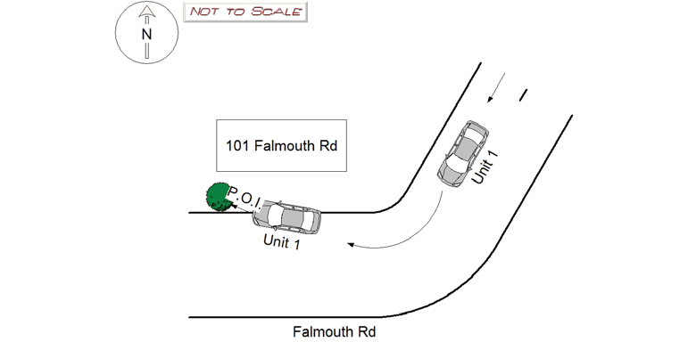
109 FALMOUTH RD
Speed
limit:
25
Violation
cited:
yes
Narrative:
Operator 1 of vehicle 1 was on Falmouth Rd heading W/B and was going too quick around the corner, lost contol and jumped the curb colliding with a tree in front of 101 Falmouth Rd. Moderate damage to the front of vehicle 1. No damage to the tree. Minor Injuries to operator 1 and passenger 1. Vehicle towed by todys towing. Operator was issued citation (T2015498) for c90s17 Speeding and c89s4A Marked Lanes violation.
Keywords:
Citation, Moderate, Speed, Tree
Dcc:
Speeding
Report
url:
Image
url:
Latitude:
42.3607487
Longitude:
-71.2304134
Location:
Case
number:
Date:
2021-11-21
Time:
17:20
Address:
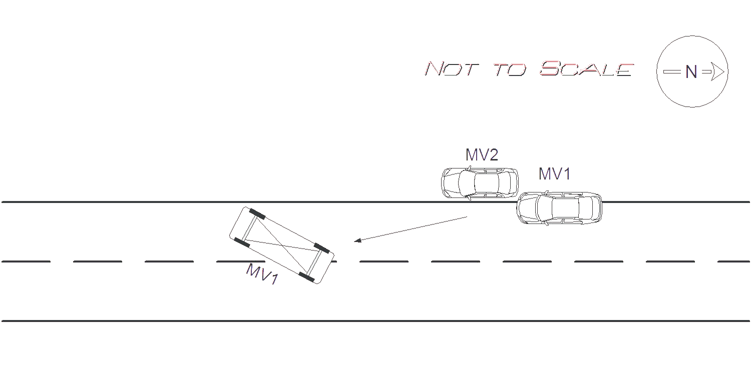
191 JACKSON RD
Speed
limit:
25
Violation
cited:
yes
Narrative:
On Sunday November 21st at approx. 1720 Hrs. I responded to 191 Jackson Rd for a motor vehicle accident roll over with entrapment. Upon arrival I witnessed MV1 on its side in the middle of Jackson Rd. The operator of MV1 was conscious and alert and was taken out of the MV by the Newton Fire Department. The operator of MV1 stated that she was driving S/B on Jackson Rd. and she did not see the parked car on the right side of the road. MV1 then tried to swerve around MV2 and clipped the left rear bumper, and left rear door of MV2 which caused MV1 to roll over onto the middle of the road. MV1 had major damage all around the vehicle and all airbags deployed. MV2 had major damage to the rear and to the left side of the MV. Due to the extensive damage and length of travel of MV1 it was estimated that MV1 was traveling at a speed greater than 35 MPH. Speed limit for Jackson Rd is 25 MPH. MV2 was pushed approx. 20 feet from where it was parked, and MV1 travelled approx 25 feet after on its drivers side after impact. The operator of MV1 was transported by EMS to NWH, and Todys's took possession of both motor vehicles. Pictures were taken and submitted to IT. The operator of MV1 was cited 90/17, speeding.
Keywords:
Airbag, Citation, Crash, Ems, Fire, Pictures, Severe, Solar, Speed
Dcc:
Speeding
Report
url:
Image
url:
Latitude:
42.3564835
Longitude:
-71.195531
Location:
Case
number:
Date:
2022-04-21
Time:
17:23
Address:
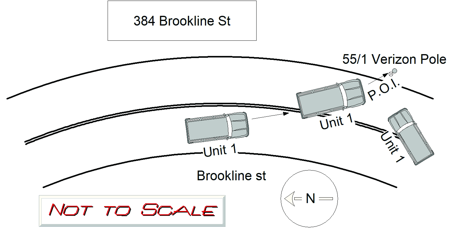
384 BROOKLINE ST
Speed
limit:
30
Violation
cited:
yes
Narrative:
OPERATOR 1 OF MV 1 WAS TRAVELING S/B ON BROOKLINE ST BY REDWOOD RD AND STATED THEY WERE TRAVELING GREATER (APPROX 40MPH) THAN THE POSTED SPEED LIMIT (30MPH) AND LOST CONTROL OF THE CAR AND CROSSED OVER THE DOUBLE YELLOW LINE AND STRUCK THE VERIZON UTILITY POLE (POLE #55/1) PASSENGER WAS INJURED AND TRANSPORTED TO THE BI NEEDHAM. OPERATOR WAS NOT INJURED AND SIGNED A REFUSAL WITH MEDICS. MAJOR DAMAGE TO MV 1, TOWED BY TODYS. VERIZON NOTIFIED FOR THE DAMAGE TO THE POLE. CITATION ISSUED TO OPERATOR 1 (MA T2012684) FOR c89s4A MARKED LANES VIOLATION AND c90s17 SPEEDING. TOWED MV SHEET COMPLETED PER DEPT PROTOCOL.
Keywords:
Citation, Speed
Dcc:
Speeding
Report
url:
Image
url:
Latitude:
42.3011172
Longitude:
-71.1828427
Location:
Advanced export
JSON shape: default, array, newline-delimited, object
CREATE TABLE "crash_reports" (
   [case_number] TEXT PRIMARY KEY,
   [datetime] TEXT,
   [date] TEXT,
   [time] TEXT,
   [address] INTEGER,
   [street1] TEXT,
   [street2] TEXT,
   [intersection] INTEGER,
   [speed_limit] INTEGER,
   [hit_run] INTEGER,
   [violation_cited] INTEGER,
   [narrative] TEXT,
   [keywords] TEXT,
   [dcc] TEXT,
   [dcc_code] TEXT,
   [report_url] TEXT,
   [image_url] TEXT
, [geocoded_address] TEXT, [latitude] TEXT, [longitude] TEXT, [manual_geocode] INTEGER, [retrieved] TEXT);