crash_reports
2 rows where dcc = "["Unknown"]", intersection = 0 and "retrieved" is on date 2021-12-22
This data as json, CSV (advanced)
Suggested facets: datetime (date), date (date), retrieved (date), keywords (array), dcc (array)
Case
number:
Date:
2021-12-16
Time:
13:26
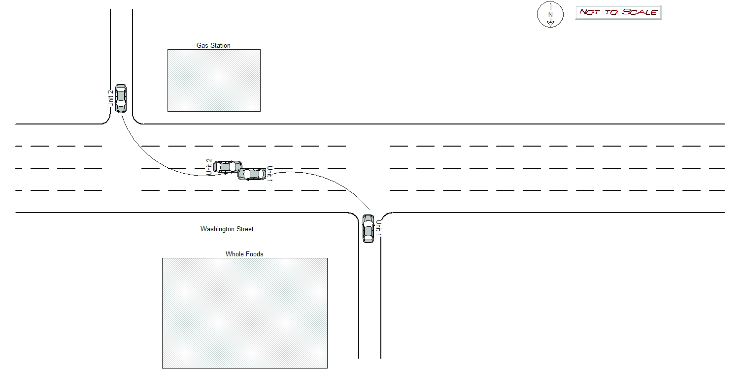
Address:
647 WASHINGTON ST
Speed
limit:
30
Violation
cited:
no
Narrative:
On December 16th, 2021 at approximately 13:26 hours while working N491 I responded to a report of a mv crash in front of Whole Foods, #647 Washington St. On my arrival I located both involved vehicles. Vehicle #1 was a 2018 Black Nissan Rogue, ma plate 492NJ8, operated by a Thomas Gemelli. He stated he was exiting Whole Foods attempting to turn left E/B onto Washington St when he crashed into vehicle #2. Mr Gemelli further stated there was a large truck turning into Whole Foods at the same time he was exiting that blocked his view of vehicle #2. Vehicle #2 was a blue 2011 Ford Fiesta, ma reg. 949RCG, operated by a Eileen Kurkoski. She stated she was exiting from the gas station at #650 Washington St attempting to go W/B on Washington St when she was struck by vehicle #1. She also reported that her view of vehicle #1 was obstructed by the same truck entering Whole Foods.
Keywords:
Crash
Dcc:
Unknown
Report
url:
Image
url:
Latitude:
42.3541087
Longitude:
-71.2000849
Location:
Case
number:
Date:
2021-12-20
Time:
11:59
Address:
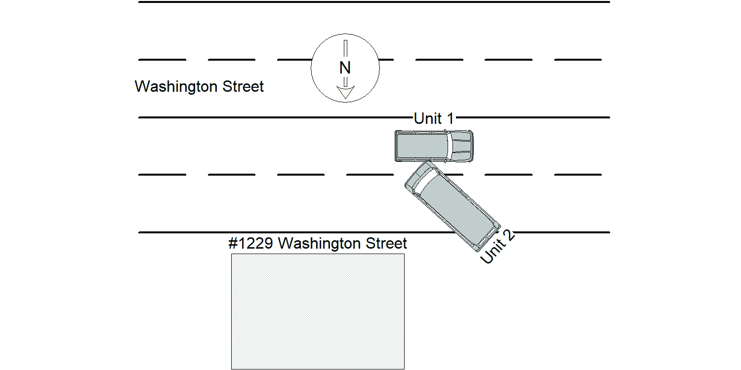
1229 WASHINGTON ST
Speed
limit:
30
Violation
cited:
no
Narrative:
The operator of MV#1 states that she was traveling west on Washington St when MV#2 exited #1229 Washington St and attempted to turn left when crash occurred. The operator of MV#2 states that he had already exited the property, was on the east bound side of Washington St when MV#1 crossed the yellow line when crash occurred. No witnesses, though Enterprise Rental at #1229 Washington St does have exterior cameras and will notify me if the crash was recorded. No tows, no injuries. I did 2 separate crash drawings for this crash because both operators had such different versions of the crash.
Keywords:
Crash
Dcc:
Unknown
Report
url:
Image
url:
Latitude:
42.349487
Longitude:
-71.2238931
Location:
Advanced export
JSON shape: default, array, newline-delimited, object
CREATE TABLE "crash_reports" (
   [case_number] TEXT PRIMARY KEY,
   [datetime] TEXT,
   [date] TEXT,
   [time] TEXT,
   [address] INTEGER,
   [street1] TEXT,
   [street2] TEXT,
   [intersection] INTEGER,
   [speed_limit] INTEGER,
   [hit_run] INTEGER,
   [violation_cited] INTEGER,
   [narrative] TEXT,
   [keywords] TEXT,
   [dcc] TEXT,
   [dcc_code] TEXT,
   [report_url] TEXT,
   [image_url] TEXT
, [geocoded_address] TEXT, [latitude] TEXT, [longitude] TEXT, [manual_geocode] INTEGER, [retrieved] TEXT);