crash_reports
5 rows where dcc = "["Unknown"]", intersection = 1 and keywords contains "Snow"
This data as json, CSV (advanced)
Suggested facets: speed_limit, keywords, datetime (date), date (date), retrieved (date), keywords (array), dcc (array)
Case
number:
Date:
2019-03-04
Time:
07:51
Address:
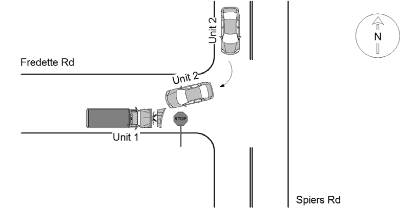
SPIERS RD & FREDETTE RD
Speed
limit:
30
Violation
cited:
no
Narrative:
Operator 1 states he was stopped at the stop sign on Fredette Rd @ Spiers Rd when vehicle 2 turned onto Fredette Rd. from Spiers Rd and struck the plow of vehicle 1. Operator 2 states that he made a right turn onto Fredette Rd from Spiers Rd. Due to the narrowing of the roadway from snow operator 2 was forced to make a wide turn and striking vehicle 1. There was minor damage to both vehicles and no injuries.
Keywords:
Snow
Dcc:
Unknown
Report
url:
Image
url:
Latitude:
42.2928458
Longitude:
-71.1811136
Location:
Case
number:
Date:
2020-01-18
Time:
19:37
Address:
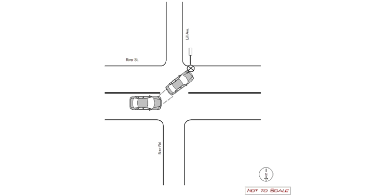
RIVER ST & LILL AVE
Speed
limit:
25
Violation
cited:
no
Narrative:
MV #1 was traveling westbound on River St. when the operator lost control of her vehicle due to the snowy conditions and crashed into the street sign on the corner of River St. and Lill Ave. The operator was not injured and the vehicle was driven from the scene. The City of Newton was notified regarding the damaged sign and photographs of the sign were taken on the N492 camera and submitted to the Newton Police It Bureau.
Keywords:
Crash, Pictures, Snow
Dcc:
Unknown
Report
url:
Image
url:
Latitude:
42.3556527
Longitude:
-71.236118
Location:
Case
number:
Date:
2020-12-09
Time:
18:42
Address:
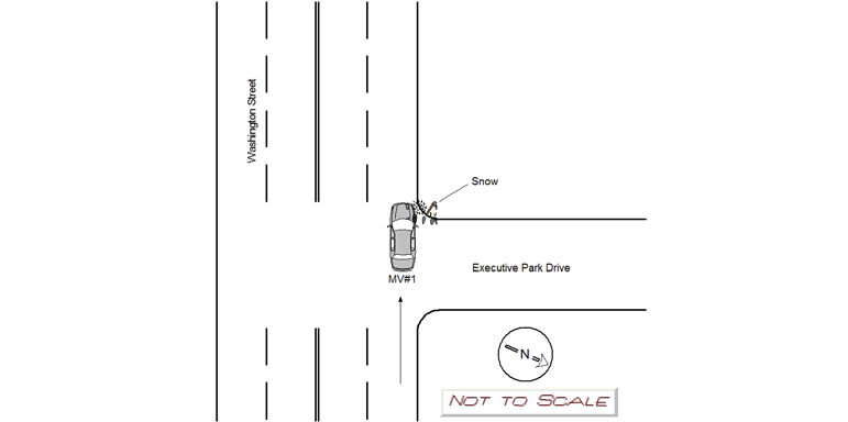
EXECUTIVE PARK DR & WASHINGTON ST
Speed
limit:
25
Violation
cited:
no
Narrative:
The OP. of MV#1 states while traveling westbound on Washington Street, he struck a snow pile at the corner of Executive Park Drive and lost control of his vehicle. His vehicle then slid along the curb before coming to a stop. A patient refusal was signed with the Medics. MV1 was towed by Todys.
Keywords:
Snow
Dcc:
Unknown
Report
url:
Image
url:
Latitude:
42.3269098
Longitude:
-71.2539591
Location:
Case
number:
Date:
2020-12-16
Time:
23:23
Address:
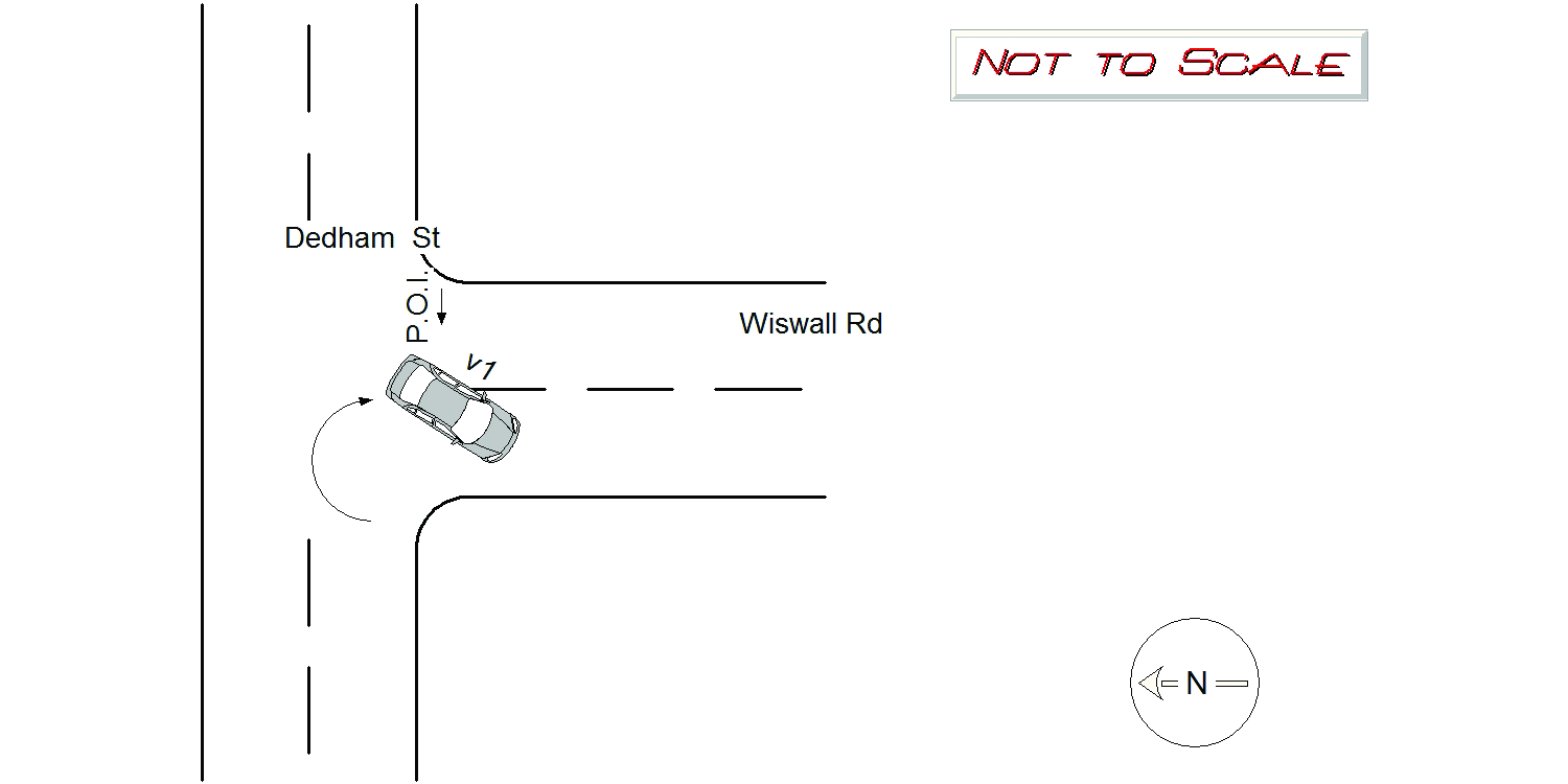
DEDHAM ST & WISWALL RD
Speed
limit:
25
Violation
cited:
no
Narrative:
Vehicle 1 was travelling eastbound on Dedham St, and took a right turn onto Wiswall Rd, While attempting to make the turn the vehicle slid on the snow, and the back left of the vehicle hit the curb. The air bags were deployed on the left side. I observed minor damage to the back left of the vehicle. No one was injured. The vehicle was towed by Tody's to their lot.
Keywords:
Snow
Dcc:
Unknown
Report
url:
Image
url:
Latitude:
42.2980951
Longitude:
-71.1848947
Location:
Case
number:
Date:
2021-02-09
Time:
13:34
Address:
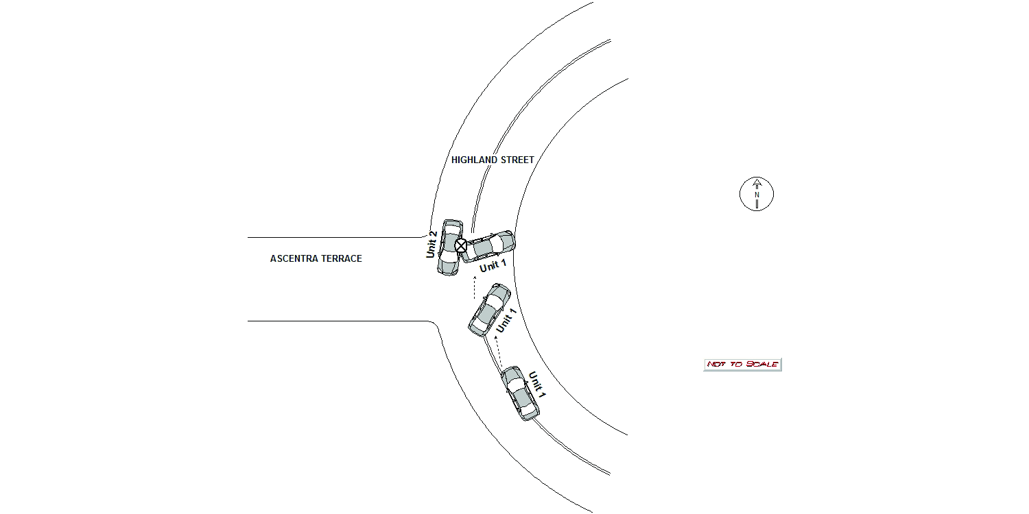
ASCENTA TER & HIGHLAND ST
Speed
limit:
25
Violation
cited:
no
Narrative:
On Tuesday February 9th, 2021 at approximately 1334 hours I responded to the intersection of Ascentra Terrace and Highland Street for a two car motor vehicle accident. At the time of the accident the weather condition was heavy snow in the area and the roads were covered in snow. Both Ascentra Terrace and Highland Street are owned and maintained by the City of Newton. Upon arrival I met with the operator of MV1 identified as Elizabeth Carron (S53478024). She stated she was heading northbound on Highland Street when she lost control of her vehicle on the bend of the road and made contact with MV2. MV1 sustained heavy rear end damage and airbag deployment. The operator of MV2 identified as David Balaban (S09328852) stated he was traveling southbound on Highland Street and could not avoid MV1 when it lost control and collided with his vehicle. MV2 sustained heavy drivers side panel damage. The Fire department and Medic 2 arrived on scene and cleared with a patient refusal. Todys responded and towed MV1 as it was inoperable.
Keywords:
Airbag, Crash, Fire, Snow
Dcc:
Unknown
Report
url:
Image
url:
Latitude:
42.344232
Longitude:
-71.22482
Location:
Advanced export
JSON shape: default, array, newline-delimited, object
CREATE TABLE "crash_reports" (
   [case_number] TEXT PRIMARY KEY,
   [datetime] TEXT,
   [date] TEXT,
   [time] TEXT,
   [address] INTEGER,
   [street1] TEXT,
   [street2] TEXT,
   [intersection] INTEGER,
   [speed_limit] INTEGER,
   [hit_run] INTEGER,
   [violation_cited] INTEGER,
   [narrative] TEXT,
   [keywords] TEXT,
   [dcc] TEXT,
   [dcc_code] TEXT,
   [report_url] TEXT,
   [image_url] TEXT
, [geocoded_address] TEXT, [latitude] TEXT, [longitude] TEXT, [manual_geocode] INTEGER, [retrieved] TEXT);