crash_reports
3 rows where dcc contains "Improper turn" and keywords contains "Tree"
This data as json, CSV (advanced)
Suggested facets: intersection, violation_cited, datetime (date), date (date), retrieved (date), keywords (array), dcc (array)
Case
number:
Date:
2021-07-06
Time:
07:28
Address:
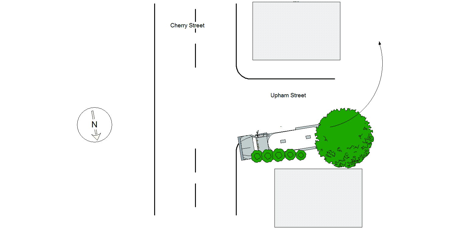
289 CHERRY ST
Speed
limit:
25
Violation
cited:
no
Narrative:
Homeowners at #289 Cherry St., identified as Midge Connolly and Walter Devine called NPD to report that a delivery truck had driven on their property causing damage. On arrival I observed significant damage to the property at #289 Cherry St along the Upham St side of the property. Damage included the lawn, bushes between the driveway and Upham St, a tree and barrels. I then spoke with the operator of MV#1 who stated that while trying to back his truck into the driveway at #297 Cherry St, which is actually located on Upham St, he backed over the property at #289 Cherry St causing the damage listed above. No injuries, no tows and I took a few photographs of the damage to the property at #289 Cherry St.
Keywords:
Bus, Pictures, Tree
Dcc:
Improper turn
Report
url:
Image
url:
Latitude:
42.3544728
Longitude:
-71.228882
Location:
Case
number:
Date:
2021-09-25
Time:
11:51
Address:
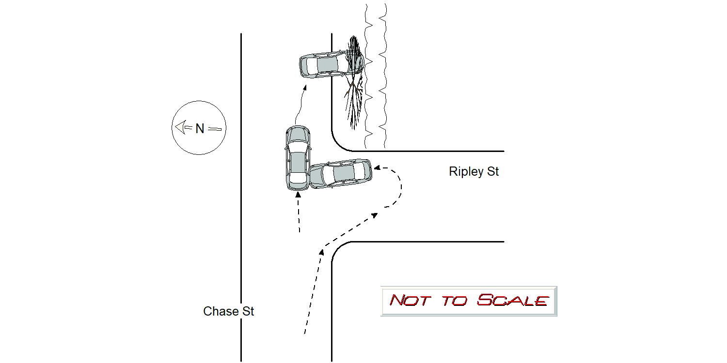
CHASE ST & RIPLEY ST
Speed
limit:
25
Violation
cited:
yes
Narrative:
Mv#1 operator stated he was travelling on Chase St E/B and then turned right onto Ripley St making a U-turn reversing his direction intending to turn left back onto Ripley St W/B. As #1 was making the U-turn, #1 struck the passenger side rear end side of Mv#2. Mv#2 operator stated he was travelling on Chase St E/B behind #1. #2 stated #1 suddenly turned right onto Ripley St making a U-turn, then struck #2 passenger rear end side as #2 was passing by. The impact pushed #2 sideways and #2 crashed over the sidewalk into a city tree and stone wall at 40 Chase St. Both operators were uninjured. Both Mvs sustained significant damage; #1 was able to be driven away with driver's side front end damage; #2 was inoperable and towed by Tody's. Photos of city tree knocked over and stone wall were submitted to the I.T. bureau. City forestry notified. Based on the following observations and statements, #1 was issued citation #T2080655 for Ch90/Sec14 Improper Turn; #1 was making a simultaneous turn and U-turn prior to colliding with #2 on its rear end side indicating #2 had already passed through most of that intersection; most of crash debris was found in proper travel lane of #2 indicating #2 was suddenly struck by #1 not allowing enough reaction time for #2 to avoid being struck.
Keywords:
Citation, Crash, Pictures, Tree
Dcc:
Improper turn, Unknown
Report
url:
Image
url:
Latitude:
42.3283825
Longitude:
-71.1922189
Location:
Case
number:
Date:
2021-10-06
Time:
07:59
Address:
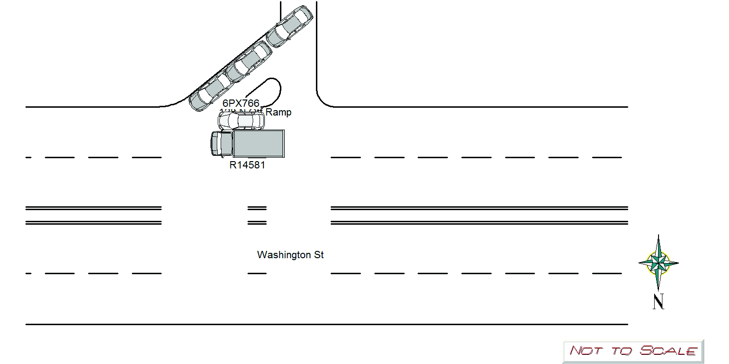
WASHINGTON ST & 128N OFFRAMP
Speed
limit:
25
Violation
cited:
no
Narrative:
On 10/6/2021 at approx 0759Hrs while assigned to 497 I responded to the area of Washington St and 128N Off Ramp for a report of a two car crash without injuries. Upon arrival I observed Ma Con Reg R14581 a large tree removal truck fully in the southern eastbound lane of Washington St. Ma Reg 6PX766, a white VW Jetta straddling the fog lane and partially into the southern Eastbound lane.I spoke with the operator of the Jetta, Jordan Glickman who stated he was stopped in traffic when the tree truck struck him. I spoke with the operator of the tree truck, Leobardo Carrillo Reyes, who stated he was travelling east on Washington St when the Jetta came up the off ramp, to avoid eastbound traffic backed up on the exit he came up the left turn lane from the exit, took and illegal right turn onto Washington St and tried to cut into the trucks lane causing the collision. Leobardo also gave me the card of a witness , Michael Minkoff who had stopped and corroborated this version of events.
Keywords:
Crash, Tree
Dcc:
Failed to yield, Improper turn
Report
url:
Image
url:
Latitude:
42.3551007
Longitude:
-71.1793551
Location:
Advanced export
JSON shape: default, array, newline-delimited, object
CREATE TABLE "crash_reports" (
   [case_number] TEXT PRIMARY KEY,
   [datetime] TEXT,
   [date] TEXT,
   [time] TEXT,
   [address] INTEGER,
   [street1] TEXT,
   [street2] TEXT,
   [intersection] INTEGER,
   [speed_limit] INTEGER,
   [hit_run] INTEGER,
   [violation_cited] INTEGER,
   [narrative] TEXT,
   [keywords] TEXT,
   [dcc] TEXT,
   [dcc_code] TEXT,
   [report_url] TEXT,
   [image_url] TEXT
, [geocoded_address] TEXT, [latitude] TEXT, [longitude] TEXT, [manual_geocode] INTEGER, [retrieved] TEXT);