crash_reports
6 rows where dcc contains "Over-steering" and "retrieved" is on date 2020-12-27
This data as json, CSV (advanced)
Suggested facets: intersection, speed_limit, keywords, dcc, dcc_code, datetime (date), date (date), retrieved (date), keywords (array), dcc (array)
Case
number:
Date:
2020-10-12
Time:
16:01
Address:
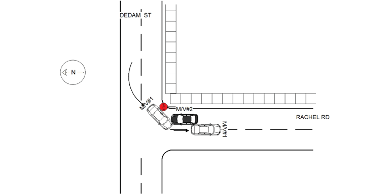
DEDHAM ST & RACHEL RD
Speed
limit:
25
Violation
cited:
no
Narrative:
Based on observations, and statements made, the following occurred. M/V#1 was traveling north on Dedham St, and as it approached Rachel Rd. it began to turn left. As it did, it collided with M/V#2 which was stopped at the Rachel Rd. stop side, in the east bound lane of Rachel Rd.
Keywords:
[]
Dcc:
Over-steering
Report
url:
Image
url:
Latitude:
42.3093682
Longitude:
-71.2011612
Location:
Case
number:
Date:
2020-10-20
Time:
13:16
Address:
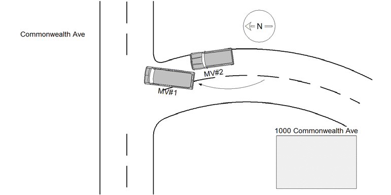
1000 COMMONWEALTH AVE
Speed
limit:
15
Violation
cited:
no
Narrative:
The operator of MV#1 stated she was travelling northbound on the driveway of 1000 Commonwealth Ave (Newton City Hall's front entrance on the Commonwealth Ave's side) when she sneezed and veered off her travel lane striking MV#2. MV#1 sustained minor damage to its passsenger's side rear bumper. There were no reported injuries to the operator of MV#1. MV#2 was parked and unoccupied on 1000 Commonwealth Ave (Newton City Hall's front entrance on the Commonwealth Ave's side) when it was struck by MV#1. MV#2 sustained heavy front end damages with its front bumper ripped off.
Keywords:
[]
Dcc:
Over-steering
Report
url:
Image
url:
Latitude:
42.3374309
Longitude:
-71.2088565
Location:
Case
number:
Date:
2020-10-28
Time:
15:43
Address:
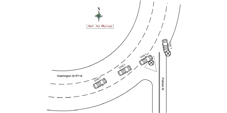
1391 WASHINGTON ST
Speed
limit:
25
Violation
cited:
no
Narrative:
Single MVA. MV lost control on the roundabout on RT 16 Washington St heading EASTBOUND, hit an island and was laid to rest on the sidewalk of the MassPike bridge on Rt-16. Heavy front end damage, airbag deployment, undercarriage and front wheels damaged as well. A witness notified Lt. DAngelo in front of NPD HQ that there was a crash and two occupants got out, a man and a woman. Lt. DAngelo was able to locate the male walking on Washington St who was involved in the crash, later identified as Jonathan Kardas. He stated that he was the passenger and his friend who was driving the vehicle but ran away. Multiple units looked for the female individual who was Sonia Walker, the owner of the MV. Kardas signed a refusal with the medics. Tody's towed the vehicle. Sonia's Iphone was secured into property locker #2 in support services for safekeeping. Dispatch made multiple attempts to contact Walker but had negative results.
Keywords:
Airbag, Crash, Walk
Dcc:
Over-steering
Report
url:
Image
url:
Latitude:
42.3484517
Longitude:
-71.2297875
Location:
Case
number:
Date:
2020-11-04
Time:
18:00
Address:
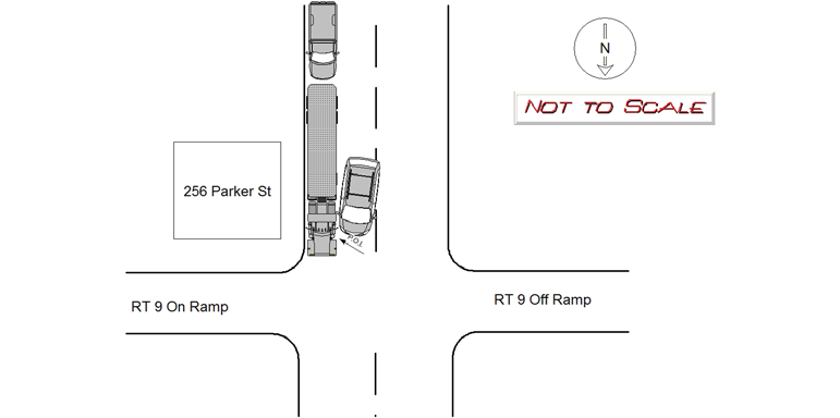
256 PARKER ST
Speed
limit:
25
Violation
cited:
no
Narrative:
Operator of MV1, David Donahue of Tody's Towing, was dispatched to 256 Parker Street at the request by me to tow a pick up truck that was obstructing traffic. While he was on scene and loading up the pick up truck on the rear of the flat bed of MV1, operator of MV2 was attempting to drive around the tow truck. MV2 struck the driver side wheel area of the flat bed tow truck. Operator of MV2 stated he was unaware his steering wheel was turned all the way to the right when he stepped on the gas. This caused him to turn into the tow truck. MV1 had damage to the drivers side and wheel and MV2 had sustained damage to his passenger side. It should be noted that it appears that MV2 already had previous damage to the same area as duct tape was observed in the area that struck MV1. Neither party was injured and neither required a tow from the scene.
Keywords:
[]
Dcc:
Over-steering
Report
url:
Image
url:
Latitude:
42.3185446
Longitude:
-71.1942138
Location:
Case
number:
Date:
2020-12-02
Time:
09:54
Address:
285 NEWTONVILLE AVE
Speed
limit:
25
Violation
cited:
no
Narrative:
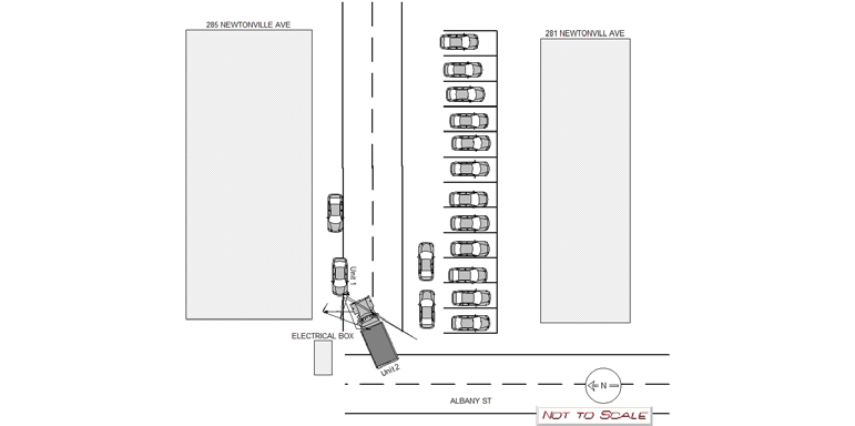
Operator of vehicle #1 City of Newton DPW employee Daniel Saulnier stated that on 12/02/2020 at 09:54 hours he was driving a City of Newton dump truck ( 2015 Frightliner MA reg MVN M9224 ) on Albany St near the driveway the runs between 281 Newtonville Ave and 285 Newtonville Ave. Saulnier stated that there were cars parked horizontally at the rear of 281 Newtonville Ave as well as two cars that were parked vertically behind the horizontal parked cars. Saulnier also stated that there was an electrical box at the north west corner of 285 Newtonville Ave. Saulnier stated that vehicle #2 ( MA par reg K5245 2017 BMW SUV ) was parked unoccupied facing east. Saulnier stated that due to the congestion caused by the vertically parked cars and the electrical box, the front driver's side of his truck's bumper made contact with the rear passenger side of vehicle two. Vehicle #1 had small scuff marks on it's driver's side front bumper. Vehicle #2 had scrapes to it's rear passenger side . Saulnier stated that he was not injured in the crash and neither vehicle required a tow. I took photos of both vehicles and had the disk downloaded by the NPD'S IT bureau.
Keywords:
Crash, Pictures
Dcc:
Over-steering
Report
url:
Image
url:
Latitude:
42.3530962
Longitude:
-71.1986533
Location:
Case
number:
Date:
2020-12-17
Time:
21:56
Address:
230 CENTRAL ST
Speed
limit:
25
Violation
cited:
no
Narrative:
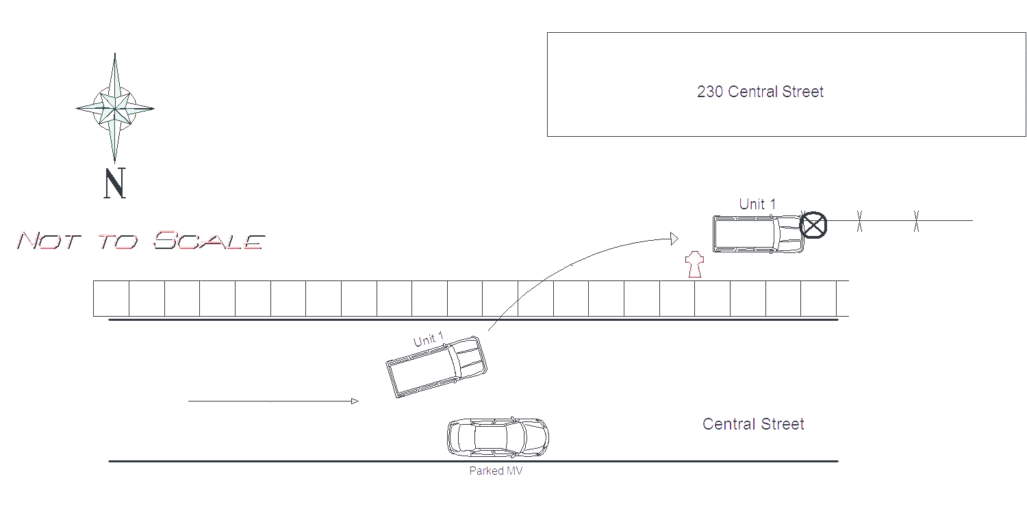
MV1 was traveling westbound on Central Street and lost control due to the snow on the road. MV1 swerved off the road and drove through a snow bank and traveled through the fence in front of 230 Central Street. Operator of MV1 stated he saw a parked car on the right hand side of the road too late which caused him to swerve. The owner of 230 Central Street, Barbara Sullivan, was notified about the damage to the fence in the front of her building. No injuries were sustained during the crash.
Keywords:
Crash, Snow
Dcc:
Swerving, Over-steering
Report
url:
Image
url:
Latitude:
42.345221
Longitude:
-71.2500673
Location:
Advanced export
JSON shape: default, array, newline-delimited, object
CREATE TABLE "crash_reports" (
   [case_number] TEXT PRIMARY KEY,
   [datetime] TEXT,
   [date] TEXT,
   [time] TEXT,
   [address] INTEGER,
   [street1] TEXT,
   [street2] TEXT,
   [intersection] INTEGER,
   [speed_limit] INTEGER,
   [hit_run] INTEGER,
   [violation_cited] INTEGER,
   [narrative] TEXT,
   [keywords] TEXT,
   [dcc] TEXT,
   [dcc_code] TEXT,
   [report_url] TEXT,
   [image_url] TEXT
, [geocoded_address] TEXT, [latitude] TEXT, [longitude] TEXT, [manual_geocode] INTEGER, [retrieved] TEXT);
