crash_reports
3 rows where dcc contains "Physical impairment", intersection = 0 and keywords contains "Pictures"
This data as json, CSV (advanced)
Suggested facets: speed_limit, hit_run, dcc, datetime (date), date (date), retrieved (date), keywords (array), dcc (array)
Case
number:
Date:
2019-01-18
Time:
06:13
Address:
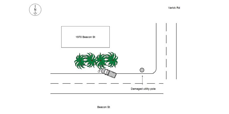
1970 BEACON ST
Speed
limit:
25
Violation
cited:
yes
Narrative:
MA commercial reg M94754 (vehicle #1), a City of Newton pickup/sander truck, was located crashed over the curb in front of 1970 Beacon St. The vehicle was unoccupied, had the keys in the ignition, and was reported stolen just a few minutes prior to discovery. The reporting party of the stolen truck and uninvolved occupant is identified as City DPW worker George Sementelli. The witness/passerby who discovered the collision is also a DPW worker, identified as Donny Brandt. Pursuant to an investigation outlined in incident #19002213, the operator at the time of the crash was determined to be Michael Carter. It is believed that Carter stole the vehicle from 295 Auburn St, fled the area, and ultimately crashed in front of 1970 Beacon St. Corroborating facts outlined in the incident report put Carter as the operator. The vehicle itself was located partially on the sidewalk and partially on the road, therefore Carter is being cited with MGL 89/4A - Marked Lanes Violation (T1268423). Due to the fact it is believed that Carter fled the scene after the crash, MGL 90/24/C - Leaving the Scene of Property Damage was added as well as MGL 90/23/D Operating After a Suspended LIcense, and MGL 90/24/O - Reckless Operation of a Motor Vehicle. The crash occurred during busy weekday commuting about 0.7 miles from Angier Elementary School. The last 3 charges mentioned have been listed on a second citation (T1268422). Officer Brooks also issued T0648082 for OUI Drugs MGL 90/24/G. See the incident report for details about this charge. In total, there are (3) citations issued to Carter. The vehicle sustained heavy front end damage. It should be noted that the utility pole a couple of houses down from the crash site (Beacon/Varick Rd, pole #212) sustained fresh, minor superficial damage, consistent with the vehicle crashing into it before verring onto the sidewalk. Pictures have been taken and submitted to the IT bureau. Tody's responded and towed the vehicle to the police garage for processing due to the pending other criminal charges involved in this accident/incident. Michael Carter was subsequently placed under arrest and his citations have been placed into his property. Carter suffered a hand injury due to the crash an was transported to NWH Hospital for an evaluation after he was booked.
Keywords:
Bus, Citation, Crash, Hospital, Pictures, School
Dcc:
Reckless driving, Physical impairment
Report
url:
Image
url:
Latitude:
42.3287455
Longitude:
-71.2449533
Location:
Case
number:
Date:
2020-04-24
Time:
18:38
Address:
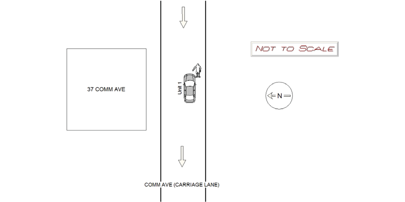
37 COMMONWEALTH AVE
Speed
limit:
30
Violation
cited:
yes
Narrative:
On Friday 04/24/2020 at approx 1838hrs, while assigned to N-494, I responded to 37 Comm Ave in Newton for MVA involving a pedestrian. Upon arrival, I observed MV1 facing the wrong way in the Comm Ave carriage lane. The pedestrian, Mark Logue, stated he was jogging EB on Comm Ave(carriage lane) on the right side when MV1 hit him from behind. He stated that he fell on his hands and injured his right elbow. Logue also stated that his cell phone screen was cracked due to hitting the pavement. Both parties refused medical treatment. Pictures were taken of injuries and submitted to IT. Operator of MV1 was cited for OUI liquor, neg operation of a MV and wrong way. See incident report #20019822
Keywords:
Citation, Ped, Phone, Pictures
Dcc:
Physical impairment
Report
url:
Image
url:
Latitude:
42.3399057
Longitude:
-71.1682955
Location:
Case
number:
Date:
2021-05-22
Time:
22:16
Address:
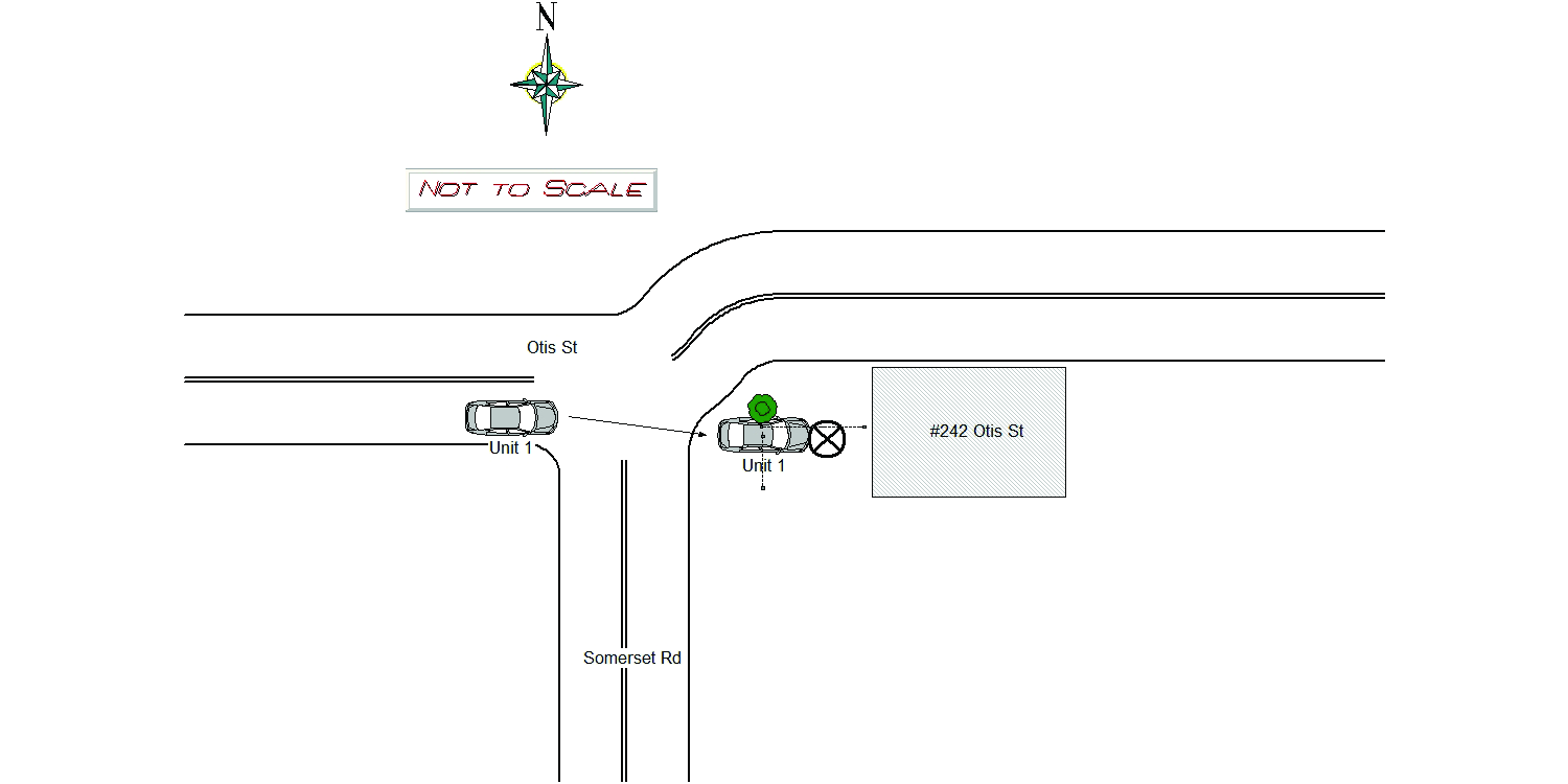
242 OTIS ST
Speed
limit:
25
Violation
cited:
yes
Narrative:
MV1 was driving EASTbound on Otis St when the operator, Philip Dare, drove into a fence belonging to 242 Otis Street. Operator showed signed of impairment and was arrested for OUI Liquor, Marked Lanes, and Negligent Operation. MV1 was towed by Tody's. MV1 sustained heavy front end and undercarriage damage. No injuries were reported by Dare. Medics and Fire arrived at the scene and Fire made the scene safe with yellow caution tape and cleared debris. Pictures taken of the damage, refer to NPD Incident #21022013.
Keywords:
Fire, Impairment, Pictures
Dcc:
Reckless driving, Physical impairment
Report
url:
Image
url:
Latitude:
42.3457125
Longitude:
-71.2173959
Location:
Advanced export
JSON shape: default, array, newline-delimited, object
CREATE TABLE "crash_reports" (
   [case_number] TEXT PRIMARY KEY,
   [datetime] TEXT,
   [date] TEXT,
   [time] TEXT,
   [address] INTEGER,
   [street1] TEXT,
   [street2] TEXT,
   [intersection] INTEGER,
   [speed_limit] INTEGER,
   [hit_run] INTEGER,
   [violation_cited] INTEGER,
   [narrative] TEXT,
   [keywords] TEXT,
   [dcc] TEXT,
   [dcc_code] TEXT,
   [report_url] TEXT,
   [image_url] TEXT
, [geocoded_address] TEXT, [latitude] TEXT, [longitude] TEXT, [manual_geocode] INTEGER, [retrieved] TEXT);