crash_reports
3 rows where dcc contains "Unknown" and "retrieved" is on date 2021-11-22
This data as json, CSV (advanced)
Suggested facets: speed_limit, hit_run, keywords, datetime (date), date (date), retrieved (date), keywords (array), dcc (array)
Case
number:
Date:
2021-10-30
Time:
18:14
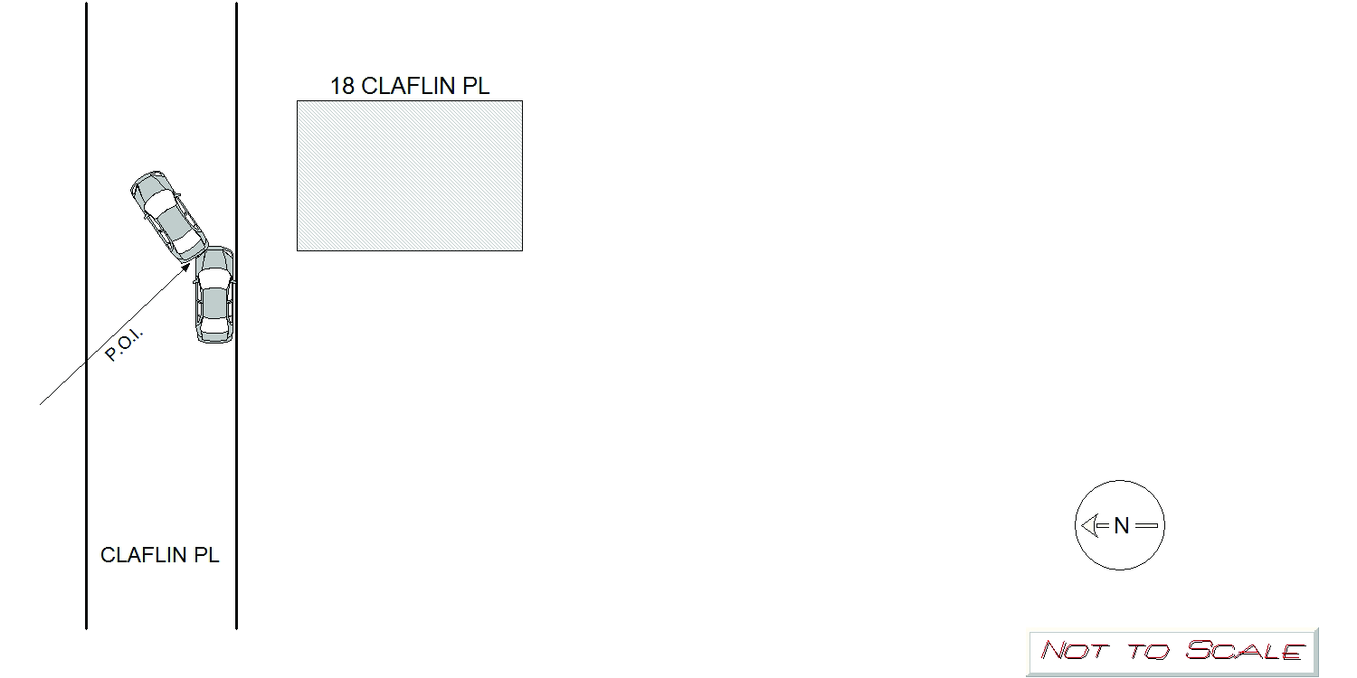
Address:
18 CLAFLIN PL
Speed
limit:
30
Violation
cited:
no
Narrative:
Vehicle 1 was legally parked along the curb in front of 18 Claflin PL. The owner of Vehicle 1 stated she noticed the front driver side bumper was cracked and caved in on 10-31-21. The damage was not there on 10-30-21 when the vehicle was parked there. It appears due to Claflin Pl. being a dead end, a vehicle attempted a 3 point like turn and backed into Vehicle 1. Vehicle 1 was unnoccupied and did not need to be towed. There is no information on the other involved vehicle.
Keywords:
[]
Dcc:
Unknown
Report
url:
Image
url:
Latitude:
42.3482792
Longitude:
-71.2057934
Location:
Case
number:
Date:
2021-11-03
Time:
12:21
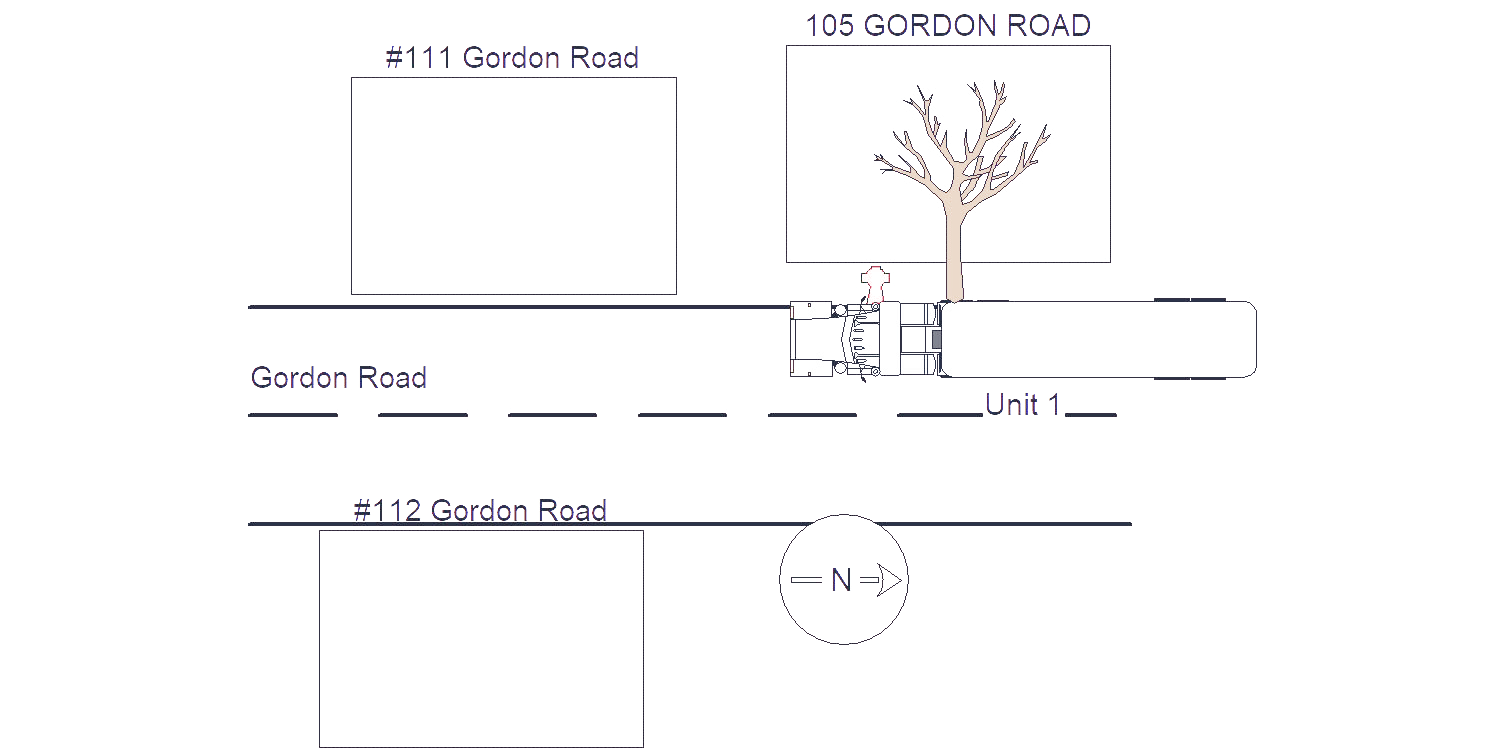
Address:
112 GORDON RD
Speed
limit:
25
Violation
cited:
no
Narrative:
When I arrived on the scene I observed a tractor trailer stopped in the middle of Gordon Rd (#112) with wires across the top of MV#1 and a city owned tree down on the ground next to the roadway. The operator of MV#1 states that his tractor trailer was detoured to Gordon Rd (south bound) from Chestnut St when he believes the top of his truck caught some low hanging wires and also took down a tree. After further observations of the downed tree and viewing additional damage to MV#1, it appears to me that the passengers side of MV#1 struck the city owned tree, knocking it down which then took down the wires. There also appeared to be damage houses (#111) in the area and at least one MV parked in the driveway at #112.
Keywords:
Tree
Dcc:
Unknown
Report
url:
Image
url:
Latitude:
42.3318245
Longitude:
-71.221387
Location:
Case
number:
Date:
2021-11-15
Time:
21:48
Address:
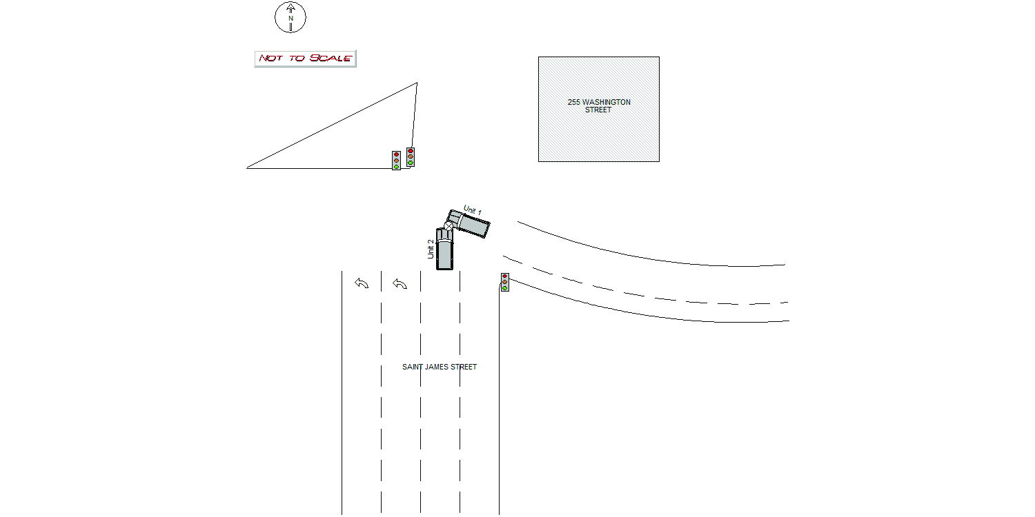
255 WASHINGTON ST
Speed
limit:
25
Violation
cited:
no
Narrative:
Operator of MV1 stated she was getting off I-90 and had the green light. Operator of MV1 stated she proceeded westbound through the intersection and was attempting to turn northbound on to Saint James Street when she was struck by MV2. Operator of MV2 stated he was traveling northbound on Saint James Street and had the green light. Operator of MV2 stated he continued through the intersection attempting to continue northbound on Saint James Street and struck MV1. There were no injuries and MV1 was towed away from the scene by Tody's. MV2 was moved to a safe location and the Operator of MV2 made arrangements through a friend to have the vehicle towed. I filled out a towed motor vehicle sheet for MV1 and provided both operators with this report number.
Keywords:
[]
Dcc:
Unknown
Report
url:
Image
url:
Latitude:
42.3578474
Longitude:
-71.1840263
Location:
Advanced export
JSON shape: default, array, newline-delimited, object
CREATE TABLE "crash_reports" (
   [case_number] TEXT PRIMARY KEY,
   [datetime] TEXT,
   [date] TEXT,
   [time] TEXT,
   [address] INTEGER,
   [street1] TEXT,
   [street2] TEXT,
   [intersection] INTEGER,
   [speed_limit] INTEGER,
   [hit_run] INTEGER,
   [violation_cited] INTEGER,
   [narrative] TEXT,
   [keywords] TEXT,
   [dcc] TEXT,
   [dcc_code] TEXT,
   [report_url] TEXT,
   [image_url] TEXT
, [geocoded_address] TEXT, [latitude] TEXT, [longitude] TEXT, [manual_geocode] INTEGER, [retrieved] TEXT);