crash_reports
4 rows where dcc contains "Visibility obstructed" and keywords contains "Tree"
This data as json, CSV (advanced)
Suggested facets: intersection, speed_limit, dcc, dcc_code, datetime (date), date (date), retrieved (date), keywords (array), dcc (array)
Case
number:
Date:
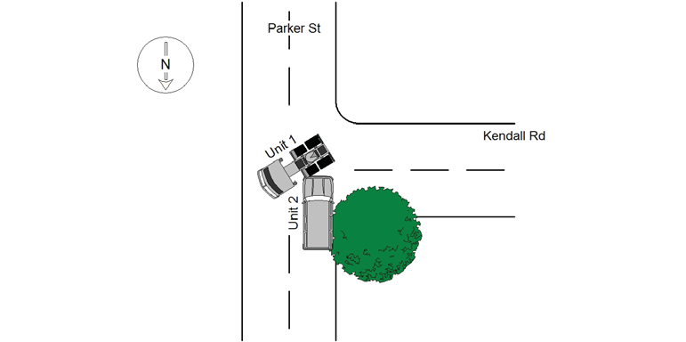
2020-08-08
Time:
09:41
Address:
310 PARKER ST
Speed
limit:
30
Violation
cited:
no
Narrative:
#1 VEHICLE WAS STOPPED ON KENDALL RD, AT THE INTERSECTION OF PARKER ST. VEHICLE #2 WAS TRAVELING DOWN PARKER ST, HEADING SOUTHBOUND. SEEING THE COAST WAS CLEAR IN BOTH DIRECTIONS, VEHICLE #1 PULLED OUT ONTO PARKER ST, IN AN ATTEMPT TO TAKE A LEFT HAND TURN. AT THIS TIME VEHICLE #2 WAS NOT PAYING ATTENTION, WAS APPARENTLY DISTRACTED AND HIS VIEW WAS OBSTRUCTED BY A TREE PARTIALLY BLOCKING HIS VIEW THEN IN TURN, DROVE INTO VEHICLE #1. VEHICLE #2 OPERATOR STATED THAT THE ACCIDENT WAS HIS FAULT AS WAS NOT PAYING ATTENTION. NO INJURIES REPORTED, VEHICLE #2 TOWED BY TODYS TOWING OF NEWTON. THERE IS A TREE AT THE INTERSECTION OF KENDALL & PARKER ST, THAT NEEDS TRIMMING THAT OBSTRUCTED BOTH DRIVERS VIEW. CITY NOTIFIED TO TRIM TREE TO PREVENT FURTHER OBSTRUCTED VIEWS.
Keywords:
Crash, Distracted, Tree
Dcc:
Visibility obstructed, Inattention
Report
url:
Image
url:
Latitude:
42.31672
Longitude:
-71.1946315
Location:
Case
number:
Date:
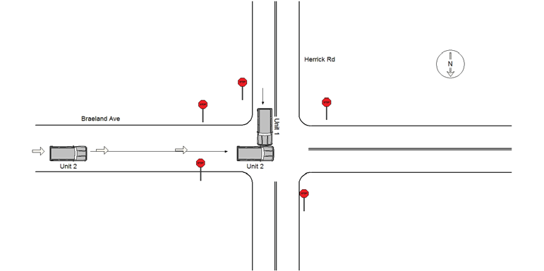
2020-08-14
Time:
13:31
Address:
BRAELAND AVE & HERRICK RD
Speed
limit:
25
Violation
cited:
no
Narrative:
Operator 1 states that he came to a complete stop on Herrick Rd at Braeland Ave. and then proceeded forward. Operator 2 was traveling Westbound on Braeland Ave and did not stop at the stop sign. Vehicle 2 pulled in front of vehicle 1 and operator 1 did not have time to stop striking vehicle 2. Operator 2 states she was traveling Westbound on Braeland Ave. She did not see the stop signs because they were covered by tree branches and leaves and proceeded forward. While traveling through the intersection vehicle 2 was struck by vehicle 1. Both vehicle sustained moderate damage and vehicle 1 was towed by Tody's. There were no injuries.
Keywords:
Moderate, Tree
Dcc:
Visibility obstructed
Report
url:
Image
url:
Latitude:
42.3288168
Longitude:
-71.1933968
Location:
Case
number:
Date:
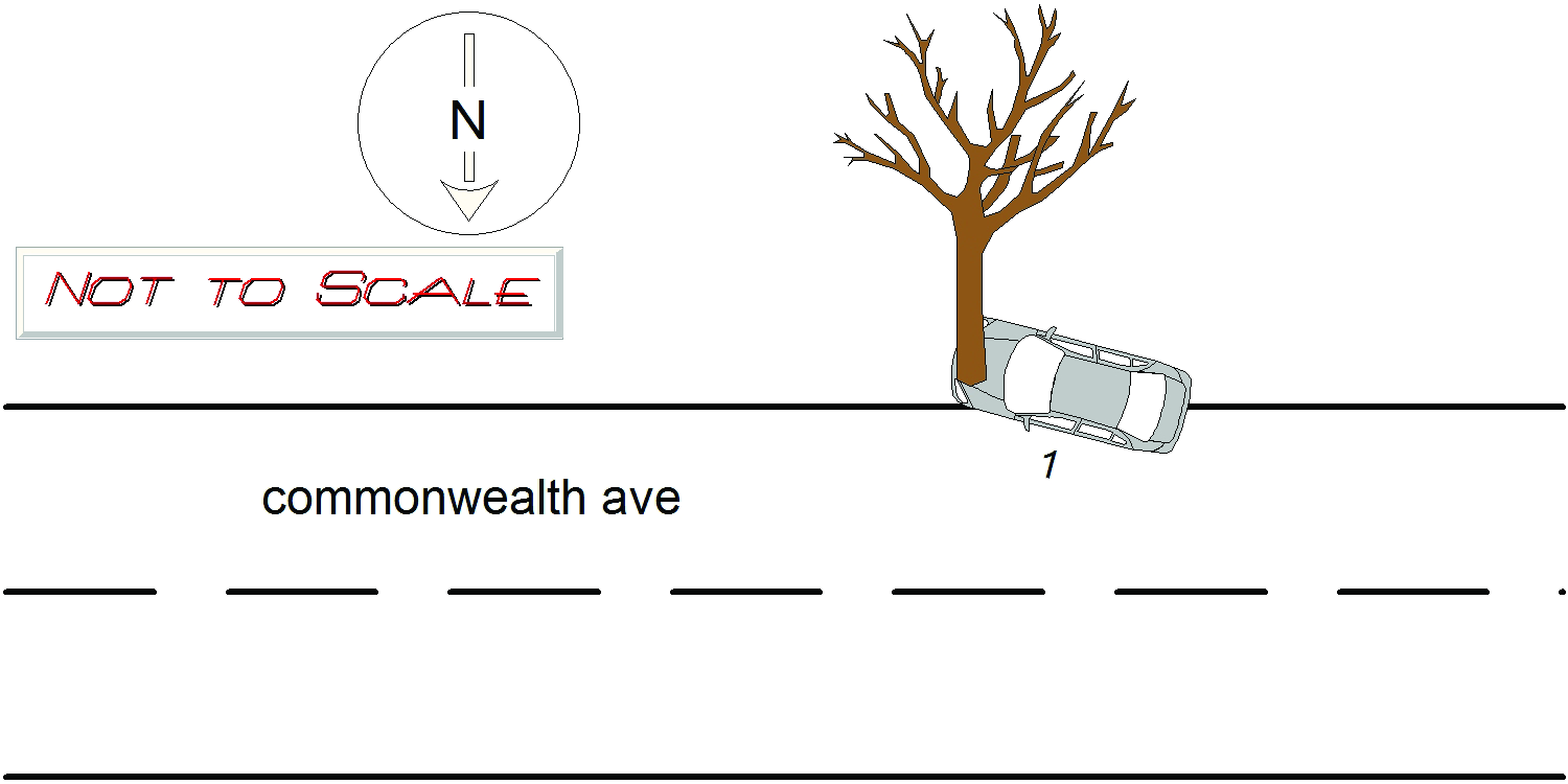
2021-01-21
Time:
19:51
Address:
2240 COMMONWEALTH AVE
Speed
limit:
30
Violation
cited:
no
Narrative:
On 1/21/21 at approximately 1950 hours, I responded to 2240 Commonwealth Ave for a car into a tree with entrapment. On arrival, I observed MA reg 457RC6 into a tree. Firefighters used jaws of life to gain access to the operator. Operator stated he was driving westbound and his windshield was fogging up and could not see. He stated that he saw the oncoming traffic and swerved and hit the tree. The operator suffered minor injuries and was transported to Mass General. The vehicle was towed by Todys.
Keywords:
Fire, Tree
Dcc:
Visibility obstructed
Report
url:
Image
url:
Latitude:
42.3469166
Longitude:
-71.2536165
Location:
Case
number:
Date:
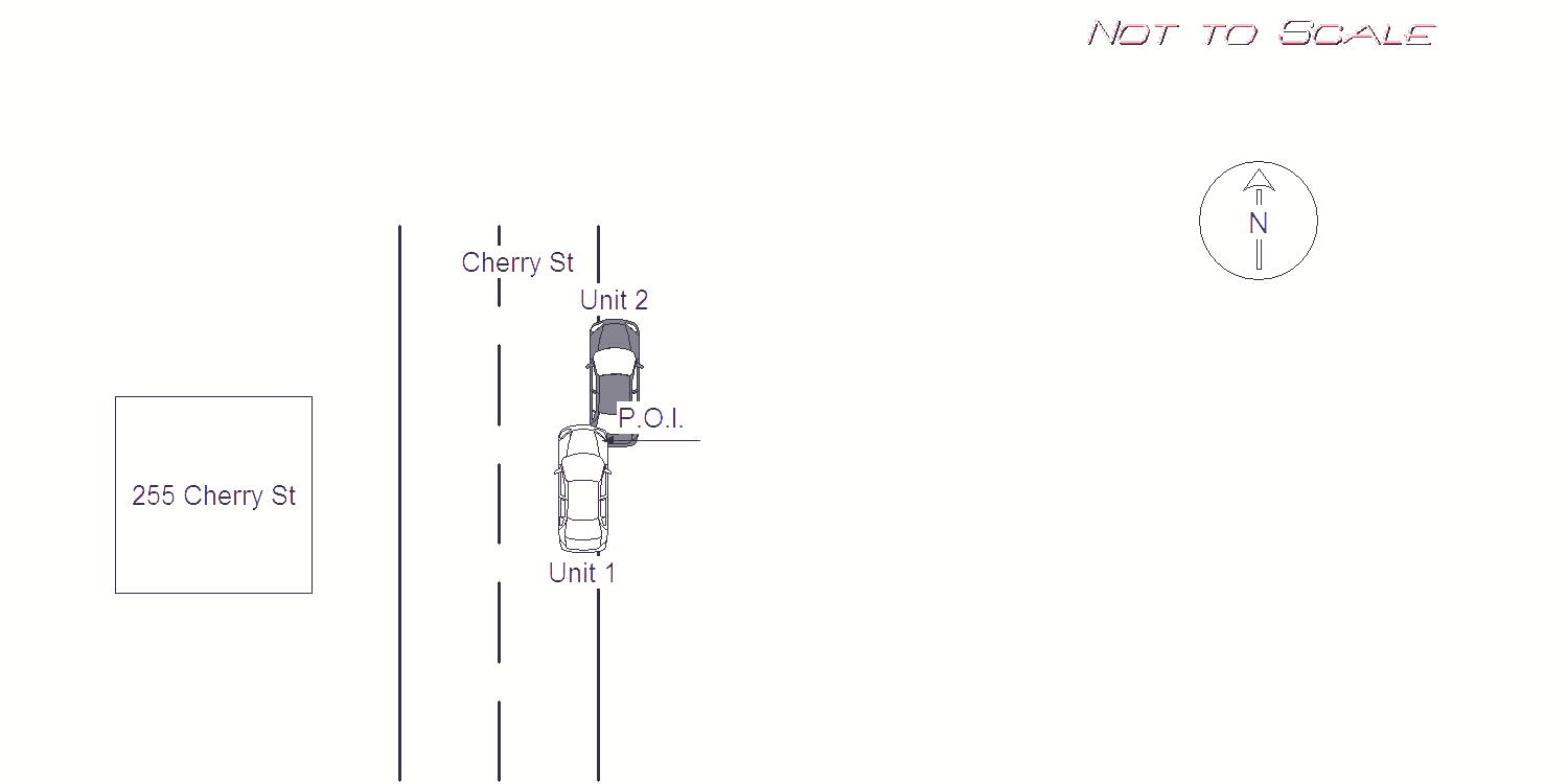
2022-06-21
Time:
21:13
Address:
255 CHERRY ST
Speed
limit:
30
Violation
cited:
no
Narrative:
MV 1 was traveling straight northbound on Cherry St when he rear ended MV 2. The operator of MV 1 (Mr. Richard Antonellis) stated he did not see the parked vehicle due to poor lighting in the roadway. I observed the street light where the crash occurred to be blocked by multiple trees on the side walk. The operator of MV 1 was not injured during the accident and signed a patient refusal with Fallon medics. The passenger of MV 1 sustained a minor cut on her nose and was treated on scene with Fallon medics and signed a refusal to be transported. MV 1 sustained major damage to its front and right side. Front and side airbags also deployed. MV 1 was towed by Tody's due to it being disabled MV 2 was legally parked on the right side of Cherry St facing Northbound. MV 1 rear ended MV 2. MV 2 was unoccupied and parked when the crash occurred. MV 2 sustained major damage to its rear and left side. MV 2 was towed by Tody's due to it being disabled.
Keywords:
Airbag, Crash, Tree, Walk
Dcc:
Visibility obstructed
Report
url:
Image
url:
Latitude:
42.355621
Longitude:
-71.2285339
Location:
Advanced export
JSON shape: default, array, newline-delimited, object
CREATE TABLE "crash_reports" (
   [case_number] TEXT PRIMARY KEY,
   [datetime] TEXT,
   [date] TEXT,
   [time] TEXT,
   [address] INTEGER,
   [street1] TEXT,
   [street2] TEXT,
   [intersection] INTEGER,
   [speed_limit] INTEGER,
   [hit_run] INTEGER,
   [violation_cited] INTEGER,
   [narrative] TEXT,
   [keywords] TEXT,
   [dcc] TEXT,
   [dcc_code] TEXT,
   [report_url] TEXT,
   [image_url] TEXT
, [geocoded_address] TEXT, [latitude] TEXT, [longitude] TEXT, [manual_geocode] INTEGER, [retrieved] TEXT);