crash_reports
1 row where dcc contains "Visibility obstructed" and latitude = "42.3167943"
This data as json, CSV (advanced)
Suggested facets: datetime (date), date (date), retrieved (date), dcc (array)
Case
number:
Date:
2019-09-17
Time:
17:13
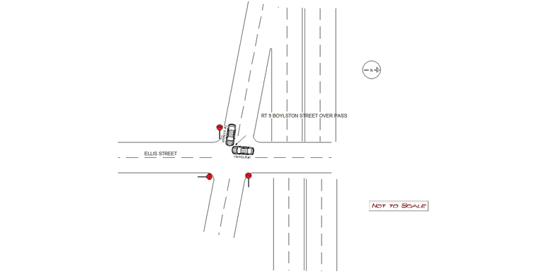
Address:
ELLIS ST & BOYLSTON STREET UNDER BRIDGE
Speed
limit:
25
Violation
cited:
no
Narrative:
Operator of Vehicle #1 stated that he was traveling south on Ellis Street when Vehicle #2 exited from the side road and struck his vehicle. Vehicle #1 sustained heavy front end damage and was towed from the scene by Todys Towing. Operator reports no injuries. Passenger in Vehicle #1 was evaluated by Newton Medics and signed a patient refusal. Operator of Vehicle #2 stated that she was exiting the side road and could not see around the Rt 9 Bridge so she slowly pulled forward and struck Vehicle #1 as it drove by. Vehicle #2 sustained heavy front end damage and was privately towed from the scene by AAA. Operator reports no injuries. It should be noted that the Operator of Vehicle #1 did not have a stop sign from his direction of travel.
Keywords:
[]
Dcc:
Visibility obstructed
Report
url:
Image
url:
Latitude:
42.3167943
Longitude:
-71.2269407
Location:
Advanced export
JSON shape: default, array, newline-delimited, object
CREATE TABLE "crash_reports" (
   [case_number] TEXT PRIMARY KEY,
   [datetime] TEXT,
   [date] TEXT,
   [time] TEXT,
   [address] INTEGER,
   [street1] TEXT,
   [street2] TEXT,
   [intersection] INTEGER,
   [speed_limit] INTEGER,
   [hit_run] INTEGER,
   [violation_cited] INTEGER,
   [narrative] TEXT,
   [keywords] TEXT,
   [dcc] TEXT,
   [dcc_code] TEXT,
   [report_url] TEXT,
   [image_url] TEXT
, [geocoded_address] TEXT, [latitude] TEXT, [longitude] TEXT, [manual_geocode] INTEGER, [retrieved] TEXT);