crash_reports
2 rows where dcc contains "Wrong way" and time = "15:01"
This data as json, CSV (advanced)
Suggested facets: datetime (date), date (date), retrieved (date), keywords (array), dcc (array)
Case
number:
Date:
2020-01-24
Time:
15:01
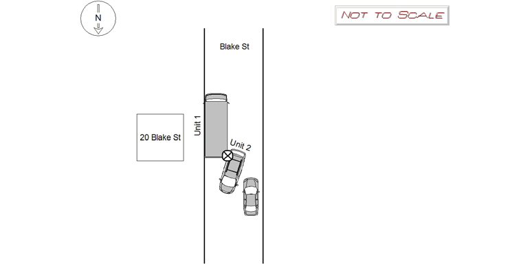
Address:
20 BLAKE ST
Speed
limit:
25
Violation
cited:
no
Narrative:
Operator of MV2 was traveling north on Blake St in the area of 20 Blake St. He attempted to travel around MV1, which was parked the wrong way in front of 20 Blake. A vehicle stopped southbound caused limited room for MV2 to get through while passing MV1. While attempting to pass, the passenger side rear of MV2 made contact with the rear passenger side of MV1. The collision cause minor damage to each vehicle. There were no tows or injuries. Photos were taken of the scene and submitted to IT.
Keywords:
Pictures
Dcc:
Wrong way, Over-steering
Report
url:
Image
url:
Latitude:
42.3474968
Longitude:
-71.1984373
Location:
Case
number:
Date:
2020-07-17
Time:
15:01
Address:
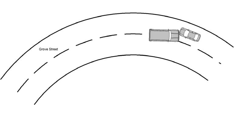
29 GROVE ST
Speed
limit:
25
Violation
cited:
yes
Narrative:
The operator of MV#1 states that she was traveling east on Grove St in the area of #29 Grove St when MV#2, who was traveling westbound on Grove St crossed the center line and crashed into MV#1. The operator of MV#2 stated that she was traveling west on Grove St and had difficulty maneuvering the sharp curve, crossed the center line and crashed into MV#1. Operator #2 stated that her MV may have had some mechanical issues that prevented her from operating her MV just prior to the crash. Operator #1 transported to NWH with a wrist injury and operator #2 cited for crossing the center line.
Keywords:
Citation, Crash
Dcc:
Wrong way
Report
url:
Image
url:
Latitude:
42.3452887
Longitude:
-71.2468414
Location:
Advanced export
JSON shape: default, array, newline-delimited, object
CREATE TABLE "crash_reports" (
   [case_number] TEXT PRIMARY KEY,
   [datetime] TEXT,
   [date] TEXT,
   [time] TEXT,
   [address] INTEGER,
   [street1] TEXT,
   [street2] TEXT,
   [intersection] INTEGER,
   [speed_limit] INTEGER,
   [hit_run] INTEGER,
   [violation_cited] INTEGER,
   [narrative] TEXT,
   [keywords] TEXT,
   [dcc] TEXT,
   [dcc_code] TEXT,
   [report_url] TEXT,
   [image_url] TEXT
, [geocoded_address] TEXT, [latitude] TEXT, [longitude] TEXT, [manual_geocode] INTEGER, [retrieved] TEXT);