crash_reports
3 rows where dcc_code = "[11]", keywords contains "Crash" and speed_limit = 30
This data as json, CSV (advanced)
Suggested facets: intersection, violation_cited, datetime (date), date (date), retrieved (date), keywords (array), dcc (array)
Case
number:
Date:
2020-01-18
Time:
19:53
Address:
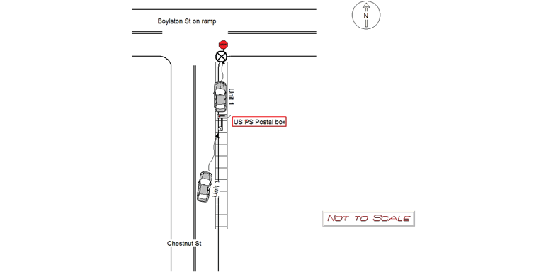
CHESTNUT ST
Speed
limit:
30
Violation
cited:
no
Narrative:
MV 1 was traveling north on Chestnut St when she slid into the curb striking a USPS post mail box and stop sign. The operator of MV 1 lost control of the vehicle due to inclimate weather and slid into the side of the road striking the objects. The operator was not injured by the crash. Pictures of the mailbox and stop sign were taken and passed into the Newton Police IT department. The vehicle was towed due to it being disabled on a public way. A towed motor vehicle inventory sheet was filled out and filed. Postal police was notified of the downed box.
Keywords:
Crash, Pictures
Dcc:
Swerving
Report
url:
Image
url:
Latitude:
42.3307093
Longitude:
-71.2247899
Location:
Case
number:
Date:
2021-02-09
Time:
13:23
Address:
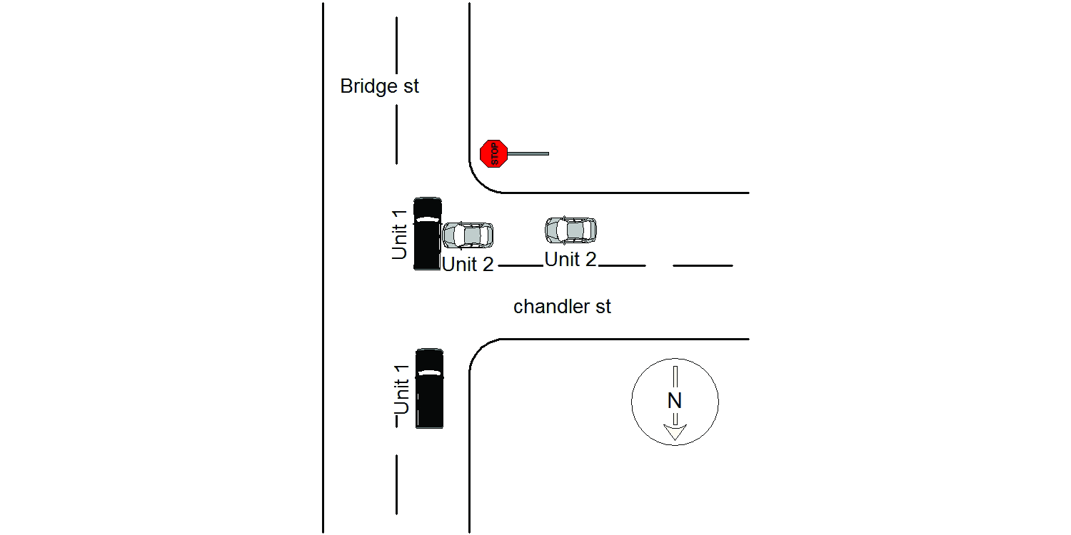
BRIDGE ST & CHANDLER ST
Speed
limit:
30
Violation
cited:
no
Narrative:
On February 9th, 2021 at approximately 13:23 hours while working N491 I responded to the intersection of Bridge St @ Chandler St for a reported MV crash . On my arrival I identified operator #1 as Angelica Beker, operating a Black Volvo SUV. She reported going S/B on Bridge St when vehicle #2 came out into the intersection from Chandler St crashing into her vehicle. Operator #2 identified as Carly Lazarus was operating a grey 2015 Honda civic. She reported being on Chandler St E/B and as she approached the intersection of Bridge St she attempted to stop but due to the snowy surface slid out into the intersection striking vehicle #1. Neither vehicle needed to be towed.
Keywords:
Crash, Snow
Dcc:
Swerving
Report
url:
Image
url:
Latitude:
42.3615389
Longitude:
-71.202328
Location:
Case
number:
Date:
2021-11-27
Time:
10:52
Address:
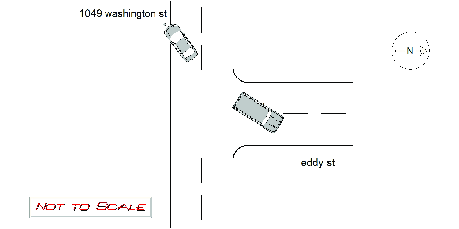
1061 WASHINGTON ST
Speed
limit:
30
Violation
cited:
yes
Narrative:
ON 11-27-21 AT APPROX. 1052HRS. WHILE WORKING N492 I TOOK A REPORT FOR MOTOR VEHICLE ACCIDENT. UPON ARRIVAL AT 1049 WASHINGTON ST. I SPOKE TO THE OPERATOR OF VEHICLE #1. DRIVER STATES HE WAS TRAVELING W-BOUND ON WASHINGTON ST. HE STATES VEHICLE #2 PULLED IN FRONT OF HIM CUTTING HIM OFF AND IN AN EFFORT TO AVOID HITTING HER HE STRUCK A UTILITY POLE IN FRONT OF 1049 WASHINGTON ST. VEHICLE #2 STATES SHE WAS DRIVING E-BOUND ON WASHINGTON ST ATTEMPTING TO TURN LEFT ONTO EDDY ST. DRIVER STATES SHE SAW VEHICLE #1 APPROACHING BUT HE WAS FAR ENOUGH AWAY FOR HER TO TURN LEFT. DRIVER #2 STATES VEHICLE #1 SPED UP AS SHE WAS TURNING AND SWERVED LEFT AVOIDING HITTING HER AND WENT ACROSS THE E-BOUND LANE EVENTUALLY STOPPING WHEN HE CRASHED INTO THE UTILITY POLE IN FRONT OF 1049 WASHINGTON ST. VEHICLE #1 HAD EXTENSIVE FRONT END DAMAGE AND FRONT AIRBAG DEPLOYMENT. VEHICLE #2 HAD NO DAMAGE AND WAS NOT INVOLVED IN THE ACCIDENT. BOTH PARTIES REPORTED NO INJURIES. DRIVER #1 WAS EVALUATED BY MEDICS AND SIGNED A PATIENT REFUSAL. VEHICLE #1 WAS TOWED BY TODYS. ALL PARTIES ADVISED TO CONTACT THEIR INSURANCE COMPANIES. THE UTILITY POLE AT 1049 WASHINGTON ST WAS CUT IN HALF AS A RESULT OF THE CRASH. THE BOTTOM HALF WAS ON THE GROUND. THE TOP HALF WAS AIRBORNE AND HELD UP BY THE ATTACHED WIRES.EVERSOURCE ARRIVED ON SCENE TO FIX THE POLE. DRIVER OF VEHICLE #1 STATED HE DID NOT HAVE A LICENSE AND OFFERED ME A BRAZILIAN PASSPORT. I CITED THE DRIVER ( CITATION NUMBER# T2080809 ) FOR 90/10 UNLICENSED OPERATOR. DRIVER GIVEN CITATION IN HAND. I FILED FOR A CRIMINAL APPLICATION FOR THE OFFENSE. CLEARED WITHOUT FURTHER INCIDENT. WASHINGTON ST IS A PUBLIC WAY IN THE CITY OF NEWTON.
Keywords:
Airbag, Citation, Crash, Severe
Dcc:
Swerving
Report
url:
Image
url:
Latitude:
42.3503932
Longitude:
-71.2166301
Location:
Advanced export
JSON shape: default, array, newline-delimited, object
CREATE TABLE "crash_reports" (
   [case_number] TEXT PRIMARY KEY,
   [datetime] TEXT,
   [date] TEXT,
   [time] TEXT,
   [address] INTEGER,
   [street1] TEXT,
   [street2] TEXT,
   [intersection] INTEGER,
   [speed_limit] INTEGER,
   [hit_run] INTEGER,
   [violation_cited] INTEGER,
   [narrative] TEXT,
   [keywords] TEXT,
   [dcc] TEXT,
   [dcc_code] TEXT,
   [report_url] TEXT,
   [image_url] TEXT
, [geocoded_address] TEXT, [latitude] TEXT, [longitude] TEXT, [manual_geocode] INTEGER, [retrieved] TEXT);