crash_reports
1 row where dcc_code = "[3]" and "retrieved" is on date 2021-01-22
This data as json, CSV (advanced)
Suggested facets: datetime (date), date (date), retrieved (date), keywords (array), dcc (array)
Case
number:
Date:
2021-01-13
Time:
18:02
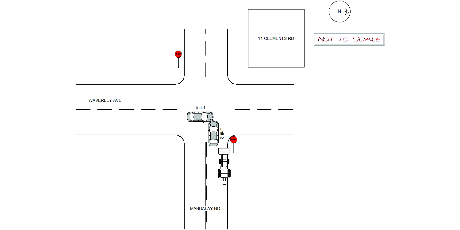
Address:
MANDALAY RD & WAVERLEY AVE
Speed
limit:
30
Violation
cited:
yes
Narrative:
On Wednesday 1/13/2021 at approx 1802hrs, while assigned to N494, I responded to the intersection of Mandalay Rd and Waverley Ave in Newton(both public ways). Upon arrival MV1 was resting on the sidewalk which damaged a brick wall(11 Clements Rd). Both vehicles involved had their airbags deployed. Operator of MV1 stated she was traveling NB on Waverley Ave. She states she did not see MV2 at all before the crash. Zwick was transported to NWH for neck pain. Operator of MV2 states she was traveling straight ahead and was attempting to cross Waverley Ave. She said she did not see the Stop sign on her side of the intersection. It should be noted that a backhoe was legally parked on Mandalay but would appear to have obstructed motorists from seeing the stop sign. Pictures were taken and submitted to IT. The owner of the brick wall that was damaged was notified. It should be noted that MV2 had an expired registration. Parrilla, operator of MV2, was cited for stop sign violation and operating an expired vehicle.
Keywords:
Airbag, Citation, Crash, Pictures
Dcc:
Signs/Signals
Report
url:
Image
url:
Latitude:
42.3408401
Longitude:
-71.1828723
Location:
Advanced export
JSON shape: default, array, newline-delimited, object
CREATE TABLE "crash_reports" (
   [case_number] TEXT PRIMARY KEY,
   [datetime] TEXT,
   [date] TEXT,
   [time] TEXT,
   [address] INTEGER,
   [street1] TEXT,
   [street2] TEXT,
   [intersection] INTEGER,
   [speed_limit] INTEGER,
   [hit_run] INTEGER,
   [violation_cited] INTEGER,
   [narrative] TEXT,
   [keywords] TEXT,
   [dcc] TEXT,
   [dcc_code] TEXT,
   [report_url] TEXT,
   [image_url] TEXT
, [geocoded_address] TEXT, [latitude] TEXT, [longitude] TEXT, [manual_geocode] INTEGER, [retrieved] TEXT);