crash_reports
1 row where dcc_code = "[3]" and "retrieved" is on date 2021-02-22
This data as json, CSV (advanced)
Suggested facets: datetime (date), date (date), retrieved (date), keywords (array), dcc (array)
Case
number:
Date:
2021-02-15
Time:
09:32
Address:
COMMONWEALTH AVE & LOWELL AVE
Speed
limit:
30
Violation
cited:
no
Narrative:
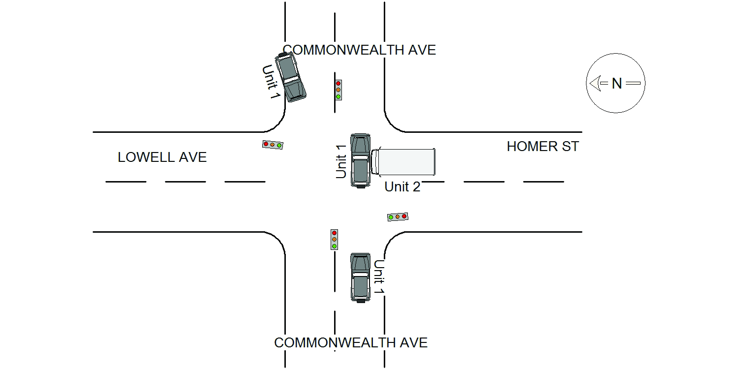
On February 15th, 2021 at approximately 09:32 hours while working N491 I responded to the intersection of Commonwealth Ave @ Lowell Ave for a reported MV crash. On my arrival I identified one of the involved parties as Robert Cosh who was operating a 2016 grey Jeep Renegade, ma plate7232BE. He reported going E/B on Commonwealth Ave and was proceeding through the intersection of Homer St/Lowell Ave when he was struck in the intersection by vehicle #2, FED EX Truck. Mr Cosh was unsure whether his light was red or green. Operator#2 identified as Guilherme Santos, was operating a 2003 FED EX truck, con plate V86030. He stated he was stopped N/B at the intersection of Homer St @ Commonwealth Ave. He further reported his light turned green then proceeded to go straight across the intersection to Lowell Ave when vehicle #1 went through the red light causing the crash. Mr Santos stated his FED EX truck is equipped with a camera which should either prove or disprove his statement regarding the color of the light prior to the crash Vehicle #1 was towed due to excessive damage by Tody's towing. There were no injuries due to this accident.
Keywords:
Crash
Dcc:
Signs/Signals
Report
url:
Image
url:
Latitude:
42.3382018
Longitude:
-71.2116096
Location:
Advanced export
JSON shape: default, array, newline-delimited, object
CREATE TABLE "crash_reports" (
   [case_number] TEXT PRIMARY KEY,
   [datetime] TEXT,
   [date] TEXT,
   [time] TEXT,
   [address] INTEGER,
   [street1] TEXT,
   [street2] TEXT,
   [intersection] INTEGER,
   [speed_limit] INTEGER,
   [hit_run] INTEGER,
   [violation_cited] INTEGER,
   [narrative] TEXT,
   [keywords] TEXT,
   [dcc] TEXT,
   [dcc_code] TEXT,
   [report_url] TEXT,
   [image_url] TEXT
, [geocoded_address] TEXT, [latitude] TEXT, [longitude] TEXT, [manual_geocode] INTEGER, [retrieved] TEXT);