crash_reports
7 rows where intersection = 0 and "retrieved" is on date 2021-05-24
This data as json, CSV (advanced)
Suggested facets: date, speed_limit, violation_cited, dcc, dcc_code, datetime (date), date (date), retrieved (date), keywords (array), dcc (array)
Case
number:
Date:
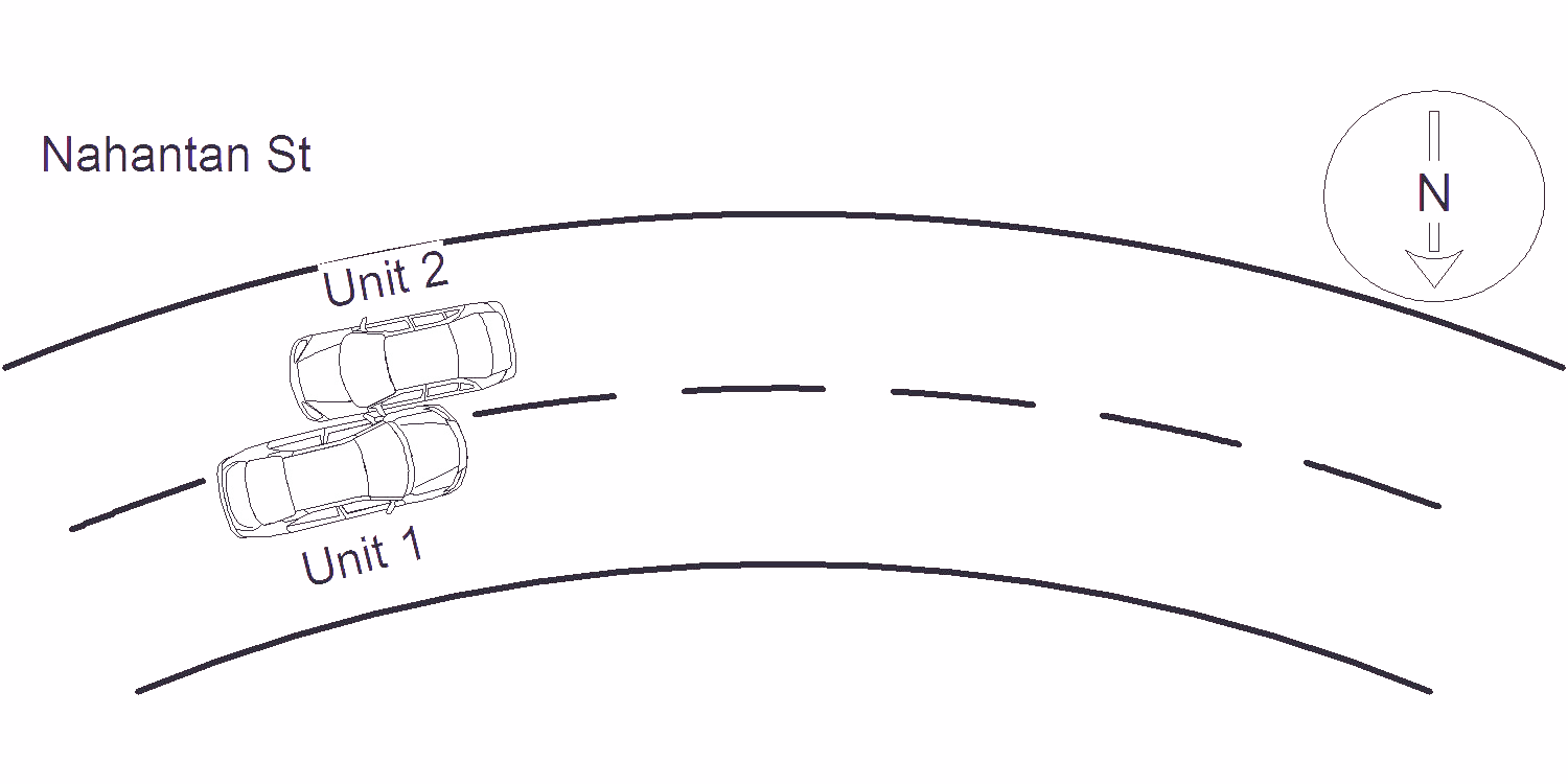
2021-05-04
Time:
10:34
Address:
125 HANANTAN ST
Speed
limit:
30
Violation
cited:
no
Narrative:
VEHICLE #1 WAS TRAVELING DOWN NAHANTAN ST, HEADING WESTBOUND, WHEN ALL OF A SUDDEN SHE SNEEZED, AT THAT TIME SHE DRIFTED OUT OF HER LANE, AND SIDESWIPED VEHICLE #2 WHO WAS TRAVELING EASTBOUND ON NAHANTAN ST. NO INJURIES REPORTED, VEHICLE #1 TOWED BY TODYS TOWING OF NEWTON, VEHICLE #2 TOWED BY AAA TOWING.
Keywords:
[]
Dcc:
Physical impairment, Illness
Report
url:
Image
url:
Latitude:
42.3370413
Longitude:
-71.2092214
Location:
Case
number:
Date:
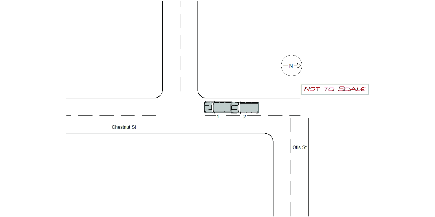
2021-05-11
Time:
16:22
Address:
6 CROCKER CIR
Speed
limit:
25
Violation
cited:
no
Narrative:
On 5/11/21 at approximately 1630 hours, I responded to the area of Crocker Cir and Chestnut St for a two car accident. Operator 1 stated that he was driving southbound on Chestnut st when a vehicle in front of him had stopped short in causing him to stop short as well. He stated that he was rear ended by Operator 2. He reported no injuries and his vehicle had minor damage. Operator 2 stated that he was driving southbound on Chestnut st when he attempted to stop in time but had rear ended Operator 1. He reported no injuries but his vehicle major damage. He arranged a tow through Audi dealership.
Keywords:
Crash
Dcc:
Followed too closely
Report
url:
Image
url:
Latitude:
42.3445589
Longitude:
-71.2236379
Location:
Case
number:
Date:
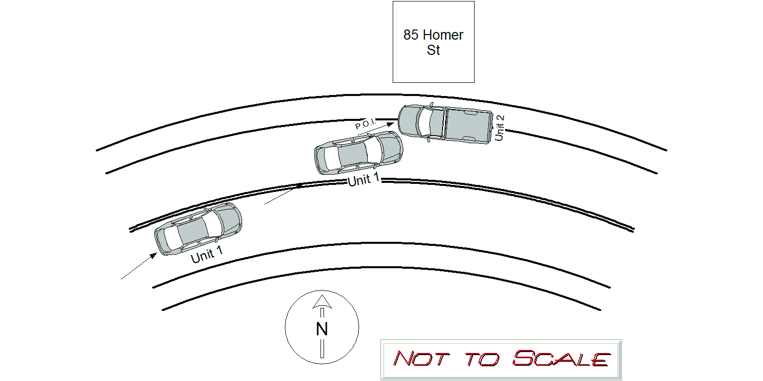
2021-05-17
Time:
21:39
Address:
82 HOMER ST
Speed
limit:
30
Violation
cited:
yes
Narrative:
Operator 1 of MV 1 was traveling EB on Homer St. Operator 1 crossed the double yellow line, across the roadway and struck parked MV2. Upon further investigation (see incident #21021174) operator 1 was charged with c90s24 OUI Liquor, c90s24 Negligent Operation of a MV and c89s4A Marked Lanes Violation. Operator 1 was transported to the NWH for his minor injuries. MA Citation T2012681 to be mailed to Operator 1. Major damage to MV1 and was towed by todys towing. MV2 was parked on the side of the road at 85 Homer St when MV1 collided with the front of MV2. Moderate damage to MV2. MV2 was towed by Todys towing.
Keywords:
Citation, Moderate
Dcc:
Reckless driving, Other improper action
Report
url:
Image
url:
Latitude:
42.3353343
Longitude:
-71.1968129
Location:
Case
number:
Date:
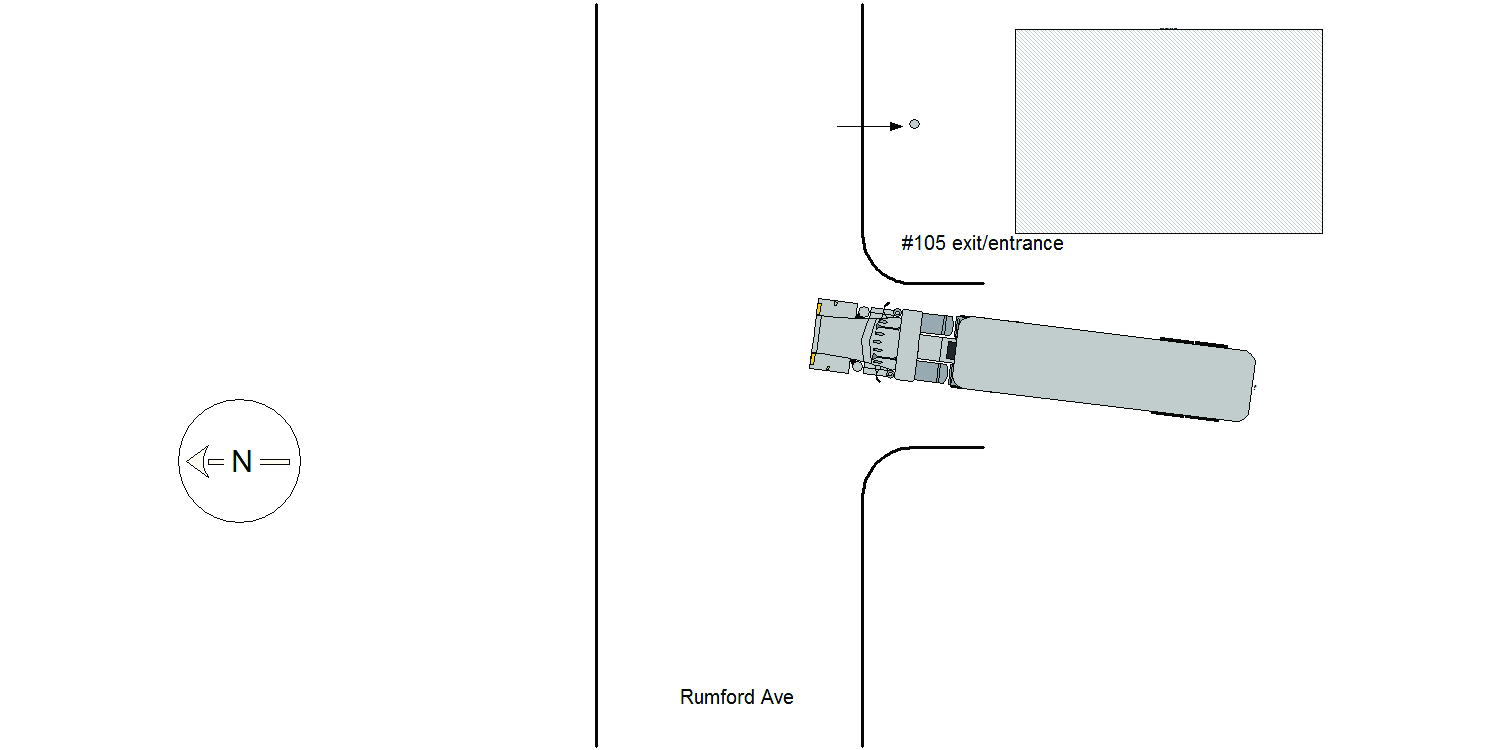
2021-05-18
Time:
08:30
Address:
105 RUMFORD AVE
Speed
limit:
25
Violation
cited:
no
Narrative:
The operator of MV#1 states that he was exiting #105 Rumford Ave when the top of his freight caught the wires across the driveway to that address. The force of the crash snapped Edison pole #866/6 in half and took down the wires. MV#1 also sustained damage to the front windshield and cab. The Newton Fire, Waltham Fire and Waltham PD also responded as well as Eversource. There were no tows and no injuries.
Keywords:
Crash, Fire
Dcc:
[]
Report
url:
Image
url:
Latitude:
42.358273
Longitude:
-71.242456
Location:
Case
number:
Date:
2021-05-20
Time:
18:32
Address:
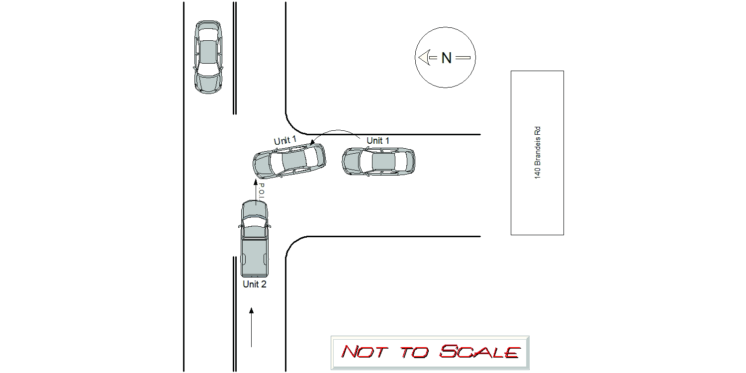
140 BRANDEIS RD
Speed
limit:
30
Violation
cited:
no
Narrative:
Operator 1 of MV 1 was pulling out of the parking lot of 140 Brandeis Rd attempting to take a left (w/b ). Operator1 looked right (e/b) and a vehicle let her out of the lot. As Operator1 was pulling out of the lot MV2 collided with the front of her vehicle. Moderate damage to MV1, towed by todys. No injuries to Operator1. Operator 2 of MV 2 was traveling e/b on Brandeis rd by #140. Operator 2 said he saw a vehicle pull out of the lot to take a left and could not stop in time. Operator 2 believes that operator 1 only looked right and did not look left as they were pulling out of the parking lot. Minor damage to MV2. No injuries to operator 2.
Keywords:
Moderate
Dcc:
Unknown
Report
url:
Image
url:
Latitude:
42.3135234
Longitude:
-71.1865424
Location:
Case
number:
Date:
2021-05-20
Time:
19:12
Address:
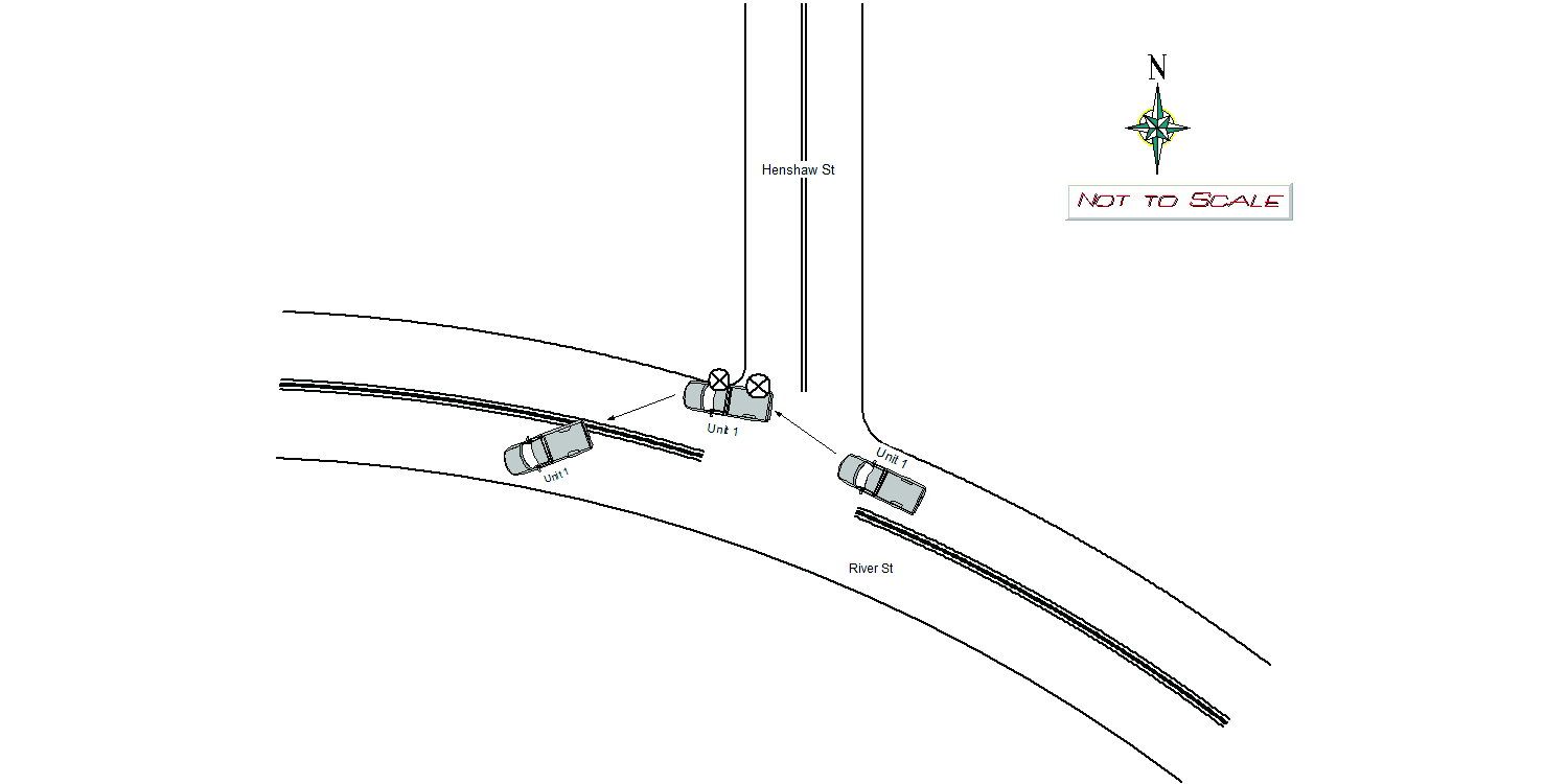
RIVER ST
Speed
limit:
25
Violation
cited:
no
Narrative:
MV1 was driving westbound on River St when he nicked the curb at the intersection of Henshaw St and blew both passenger side tires. He lost control of the vehicle when the tires blew and his vehicle laid to rest on the eastbound lane. Front airbags deployed. Operator, David English signed a refusal with the medics. MV1 was towed by Tody's towing.
Keywords:
Airbag
Dcc:
[]
Report
url:
Image
url:
Latitude:
42.3539632
Longitude:
-71.2335722
Location:
Case
number:
Date:
2021-05-22
Time:
22:16
Address:
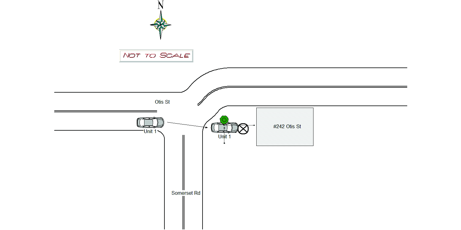
242 OTIS ST
Speed
limit:
25
Violation
cited:
yes
Narrative:
MV1 was driving EASTbound on Otis St when the operator, Philip Dare, drove into a fence belonging to 242 Otis Street. Operator showed signed of impairment and was arrested for OUI Liquor, Marked Lanes, and Negligent Operation. MV1 was towed by Tody's. MV1 sustained heavy front end and undercarriage damage. No injuries were reported by Dare. Medics and Fire arrived at the scene and Fire made the scene safe with yellow caution tape and cleared debris. Pictures taken of the damage, refer to NPD Incident #21022013.
Keywords:
Fire, Impairment, Pictures
Dcc:
Reckless driving, Physical impairment
Report
url:
Image
url:
Latitude:
42.3457125
Longitude:
-71.2173959
Location:
Advanced export
JSON shape: default, array, newline-delimited, object
CREATE TABLE "crash_reports" (
   [case_number] TEXT PRIMARY KEY,
   [datetime] TEXT,
   [date] TEXT,
   [time] TEXT,
   [address] INTEGER,
   [street1] TEXT,
   [street2] TEXT,
   [intersection] INTEGER,
   [speed_limit] INTEGER,
   [hit_run] INTEGER,
   [violation_cited] INTEGER,
   [narrative] TEXT,
   [keywords] TEXT,
   [dcc] TEXT,
   [dcc_code] TEXT,
   [report_url] TEXT,
   [image_url] TEXT
, [geocoded_address] TEXT, [latitude] TEXT, [longitude] TEXT, [manual_geocode] INTEGER, [retrieved] TEXT);