crash_reports
3 rows where intersection = 0 and "retrieved" is on date 2022-01-15
This data as json, CSV (advanced)
Suggested facets: hit_run, dcc, dcc_code, datetime (date), date (date), retrieved (date), keywords (array), dcc (array)
Case
number:
Date:
2022-01-06
Time:
20:09
Address:
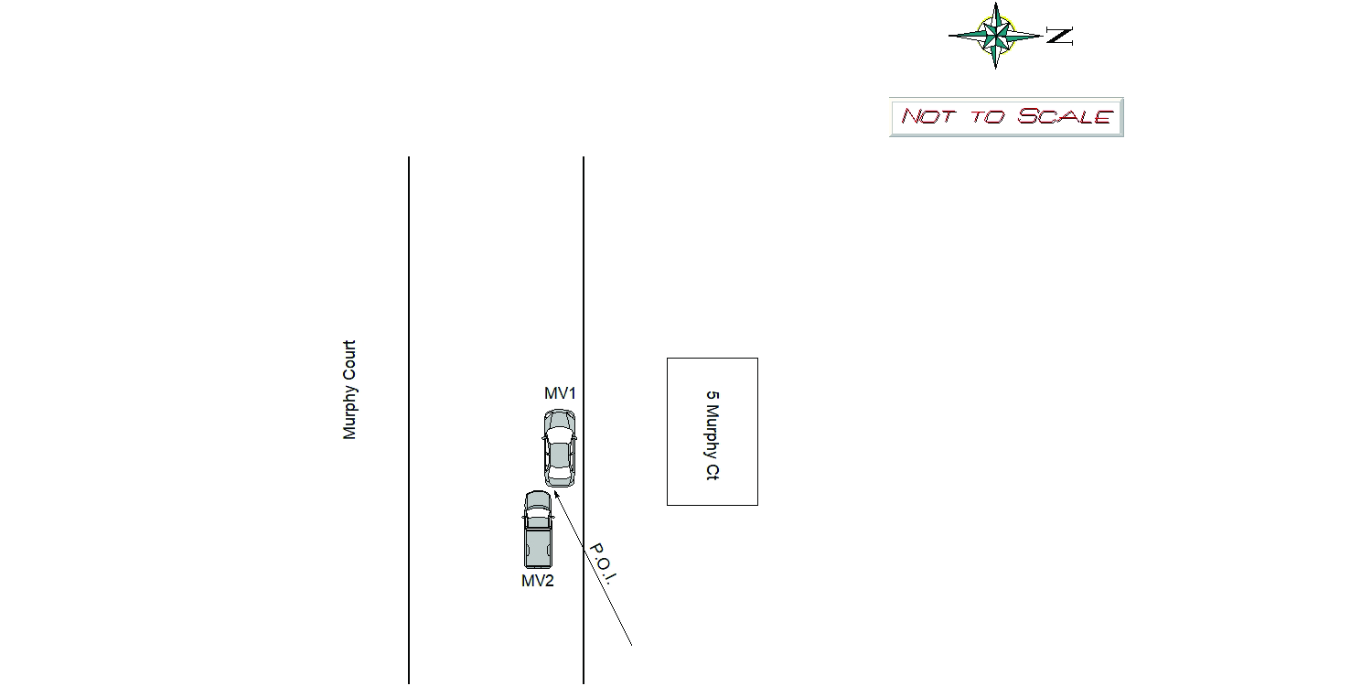
5 MURPHY CT
Speed
limit:
25
Violation
cited:
no
Narrative:
Owner of MV1 called in a hit and run. Owner has a dash camera that turns on when the vehicle is hit with force. Owner of MV1 received a notification, walked outside and observed damage to his vehicle. Owner of MV1 showed me the video. I observed the vehicle turn on and a short time later a white Chev pick-up drive by. MV1 suffered damage to the left rear of the vehicle. Due to the low quality picture, I could not see the license plate of MV2. I canvassed the area and found two cameras that were not recording at the time. MV2 did not stop and leave their information. Unable to find an involved vehicle.
Keywords:
Pictures, Walk
Dcc:
Unknown
Report
url:
Image
url:
Latitude:
42.3579422
Longitude:
-71.2001893
Location:
Case
number:
Date:
2022-01-07
Time:
12:51
Address:
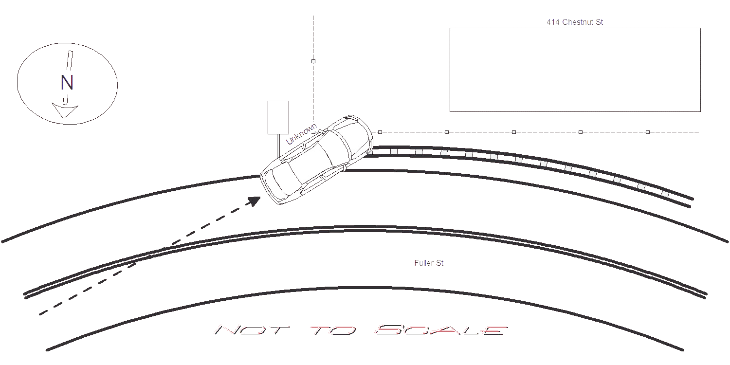
414 CHESTNUT ST
Speed
limit:
20
Violation
cited:
no
Narrative:
Unknown vehicle was travelling on Fuller St W/B at #80 Fuller St where the road bends to the right approaching Chestnut St. Based on snowy road conditions, unknown vehicle failed to negotiate bend in road and slid off road to the left. Unknown vehicle bounced off guard rail, hit a right arrow street sign and crashed through the fence belonging to the resident of 414 Chestnut St. Unknown vehicle left the scene and remains unknown. Based on snow accumulation, it appeared crash occurred several hours prior to my arrival. 414 Chestnut St homeowner and other neighbors had no information to provide at this time. The homeowner will contact NPD if any useful video becomes available. City was notified to address the hit right arrow street sign.
Keywords:
Crash, Snow
Dcc:
Unknown
Report
url:
Image
url:
Latitude:
42.3352766
Longitude:
-71.2234522
Location:
Case
number:
Date:
2022-01-08
Time:
14:06
Address:
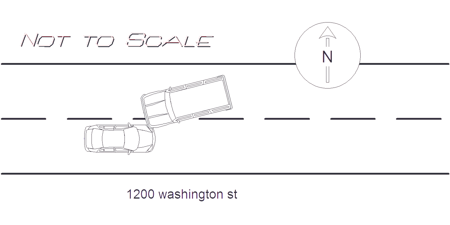
1200 WASHINGTON ST
Speed
limit:
30
Violation
cited:
no
Narrative:
ON 1-8-22 AT APPROX. 1406HRS. WHILE WORKING N492 I TOOK A REPORT FOR MOTOR VEHICLE ACCIDENT. UPON ARRIVAL AT 1200 WASHINGTON ST. ( WEST NEWTON GULF ) I SPOKE TO THE OPERATOR OF VEHICLE #1. DRIVER STATES SHE WAS TRAVELING E-BOUND ON WASHINGTON WHEN VEHICLE #2 TURNED TOWARD HER FROM THE OPPOSITE LANE AND CRASHED INTO HER VEHICLE. DRIVER OF VEHICLE #2 STATES HE WAS TRAVELING W-BOUND ON WASHINGTON ST. AND WANTED TO TURN LEFT INTO THE GULF STATION. DRIVER STATES HE MISJUDGED THE DISTANCE BETWEEN HIM AND VEHICLE #1 AND WHILE TURNING CRASHED INTO VEHICLE #1. VEHICLE #1 HAD LEFT FRONT END DAMAGE AND A FLAT LEFT FRONT TIRE AND WAS TOWED BY TODYS. VEHICLE #2 HAD LEFT FRONT END DAMAGE BUT WAS STILL OPERATIONAL. ALL PARTIES REPORTED NO INJURIES AND WERE ADVISED TO CONTACT THEIR INSURANCE COMPANIES. CLEARED WITHOUT FURTHER INCIDENT.
Keywords:
Crash
Dcc:
Inattention
Report
url:
Image
url:
Latitude:
42.3489827
Longitude:
-71.2227244
Location:
Advanced export
JSON shape: default, array, newline-delimited, object
CREATE TABLE "crash_reports" (
   [case_number] TEXT PRIMARY KEY,
   [datetime] TEXT,
   [date] TEXT,
   [time] TEXT,
   [address] INTEGER,
   [street1] TEXT,
   [street2] TEXT,
   [intersection] INTEGER,
   [speed_limit] INTEGER,
   [hit_run] INTEGER,
   [violation_cited] INTEGER,
   [narrative] TEXT,
   [keywords] TEXT,
   [dcc] TEXT,
   [dcc_code] TEXT,
   [report_url] TEXT,
   [image_url] TEXT
, [geocoded_address] TEXT, [latitude] TEXT, [longitude] TEXT, [manual_geocode] INTEGER, [retrieved] TEXT);