crash_reports
7 rows where keywords contains "Pictures" and "retrieved" is on date 2021-01-08
This data as json, CSV (advanced)
Suggested facets: intersection, speed_limit, violation_cited, keywords, dcc, dcc_code, datetime (date), date (date), retrieved (date), keywords (array), dcc (array)
Case
number:
Date:
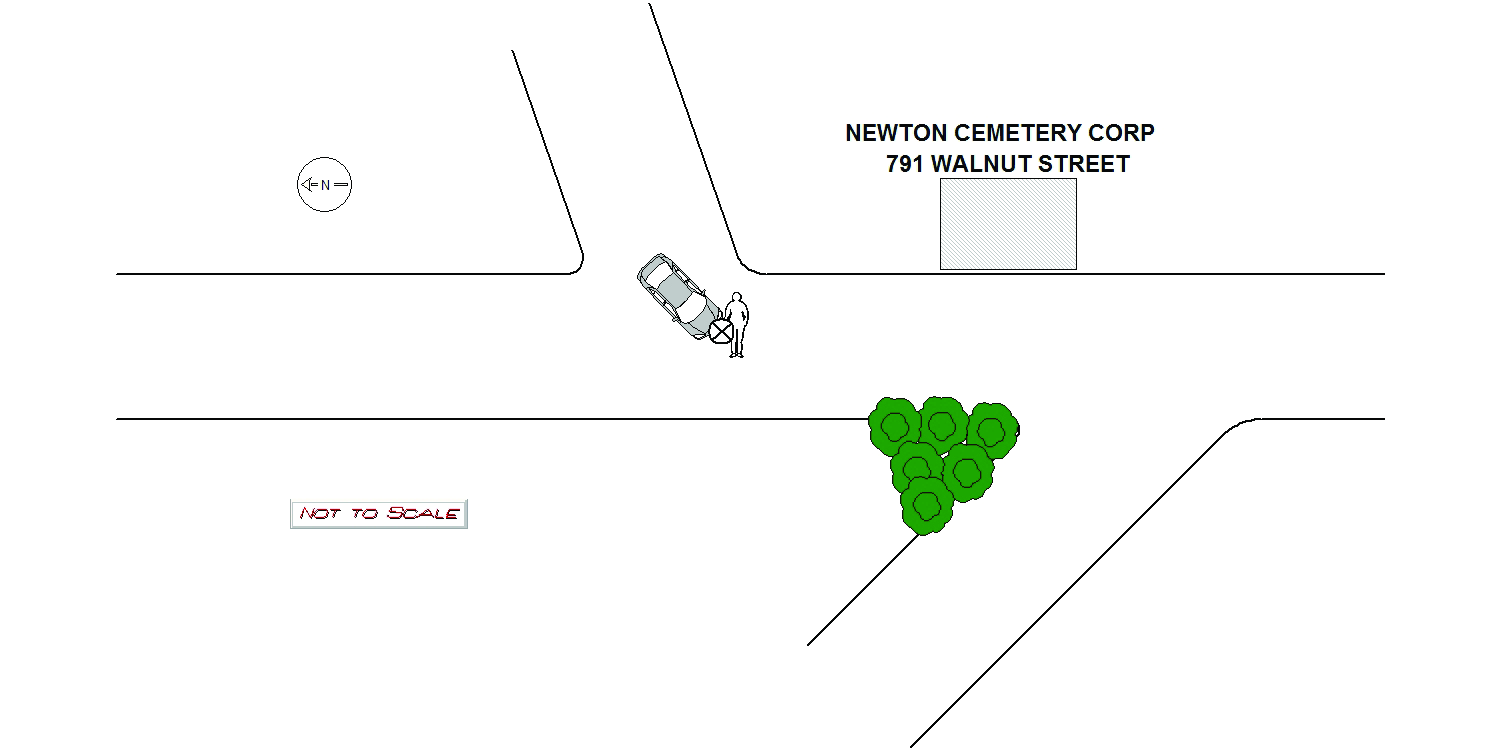
2020-10-07
Time:
11:40
Address:
791 WALNUT ST
Speed
limit:
5
Violation
cited:
no
Narrative:
On Wednesday, October 7th 2020 while in N526 I responded to 791 Walnut Street the Newton Cemetery Corp for a motor vehicle accident involving a pedestrian. At the time of the accident the weather was sunny and the road surface was dry. The accident occurred inside the cemetery on the public way by the entrance. Upon arrival I spoke with the pedestrian identified as Tova Goldring. Tova stated she was walking in the roadway when she was struck by MV1. Tova stated MV1 was turning left onto the road that leads to the exit and when she realized the operator was not stopping she put out both her hands and made contact with the hood of MV1. Tova stated the impact caused her to fall to the ground and roll into a grassy area next to the road. Tova had minor scrapes from the accident and signed a patient refusal. The operator of MV1 identified as Antonio Domenico Ricci was on scene and his primary language was Italian. I was able to contact his daughter, Daniela Boccia who arrived on scene and translated Antonio's statements. Antonio stated he was turning left onto the main road that leads to the exit of the cemetery and had his left signal activated. Antonio states the sun was glaring into his eyes and made it hard for him to see. Antonio stated he took the left turn and never saw the pedestrian. Antonio states he heard a thud on his hood and stopped the vehicle and that is when he realized he had struck a pedestrian. Antonio was not injured and there was no damage to his vehicle. Pictures of the scene and Tova's injuries were taken by Officer Wilson and submitted to the IT Bureau. Daniela took possession of MV1 and drove Antonio to his residence.
Keywords:
Crash, Ped, Pictures, Solar, Walk
Dcc:
Glare
Report
url:
Image
url:
Latitude:
42.333885
Longitude:
-71.2079645
Location:
Case
number:
Date:
2020-12-02
Time:
09:35
Address:
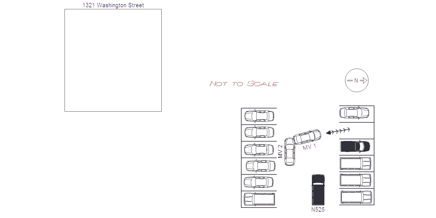
1321 WASHINGTON ST
Speed
limit:
15
Violation
cited:
no
Narrative:
On Wednesday, December 02, 2020, while assigned to Traffic unit N525, I was traveling Westbound through the rear parking lot of 1321 Washington Street at approximately 0905 hours. As I was traveling through the lot, I observed Parking Control unit 1308 backing (S) out of a parking spot ahead of me to my right. Parking Control unit 1308 is a City of Newton owned vehicle (MA MVN: MP1308). I stopped my vehicle in the roadway to allow 1308 to continue backing out of their parking spot. As 1308 continued to backing, the rear driver side bumper area of the vehicle crashed into the front passenger side bumper/fender area of Parking Control unit 1309 (MA MVN: MP5E). Parking Control unit 1309 was parked (W) in the roadway unoccupied. I observed no damage to either vehicle. The operator of Parking Control unit 1308 exited her vehicle and was identified as Parking Control Officer Angela Foley. PCO Foley stated she was backing her vehicle out of its parking spot and did not see 1309 parked behind her. PCO Foley stated the vehicle was in her blind spot. PCO Foley was asked if she was injured as a result of the crash. PCO Foley stated she was not. Photos were taken of both vehicles to document the crash and submitted to the IT Bureau.
Keywords:
Crash, Pictures
Dcc:
Inattention
Report
url:
Image
url:
Latitude:
42.3494467
Longitude:
-71.2276058
Location:
Case
number:
Date:
2020-12-05
Time:
21:48
Address:
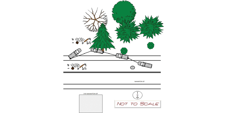
291 NAHANTON ST
Speed
limit:
25
Violation
cited:
yes
Narrative:
On 12/05/2020 at approximately 22:00 hours I was called in to respond to a single vehicle crash with serious injuries in the area of 291 Nahanton St. Nahanton St is a pubic way in the City of Newton. Upon my arrival at the crash scene with Sgt Devine I was briefed by Officers Daly and Anderson, ( see Ofc Daly's report for further information CAD # 20054728 in regard to changes take out against the operator of the truck ) I made the following observations of the crash scene, Nahanton St is a public way in the City of Newton that is a two way roadway divided by an unprotected merdium ( double yellow line ) that runs east to west. The roadway surface was wet due snow and ice. The roadway was plowed and the snow was pushed to the shoulder, althought wet the roadway was icy. There was approximately 2 inches of snow on the shoulders of the roadway. The road was light with overhead head street lights. The posted speed limit is 25 MPH. I observed a 2013 Chevrolet Silverado pick up truck that had major front end damage. The Chevrolet was at an angle with it's front end facing west bound and resting on the grass shoulder and into a wooded area. The Chevrolet rear was sticking out into the shoulder of the east bound lane of Nahanton St. The passenger side front and rear doors of the Chevrolet had been removed by the fire department to extricate the driver and passenger. The driver and passenger side air bags were deployed . The front passenger side windshield of the Chevrolet was completely missing and the driver's side had completely shattered. The front tires, hood, and engine had been compacted on it's self. The front and rear driver's side doors had been mechanically open by the fire department. The speedometer needle had stopped at 54 MPH. The Chevrolet left the roadway and left tire marks in the snow in the eastbound bike lane of Nahanton St. At a 106.4 feet from the beginning of the tire marks the first point of impact was with two tree stumps that were 3.5 feet from the roadway, four feet tall and 3.5 feet in diameter. The tire marks continue in the east bound bike lane and exit the roadway and onto a dirt shoulder at 136.1 feet from the beginning of the tire marks. The truck continued to the right of a utility pole and then it's passenger side made contact with a tree at 170.8 feet from the begin of the tire marks. The tree was 12 feet from the bike lane approximately 5 feet in diameter. The impact with the tree caused the truck to turn so that the rear was facing north east on the dirt shoulder and bike lane. The final point of rest of the rear passenger side tire was 200 feet from the beginning of the tire marks. The truck's rear diver side tire final point of rest was 209 feet from the beginning of the tire marks. The front driver's side tire was compacted into the trucks engine and the passenger side front tire was located behind the tree approximately 20 feet from the roadway. Sgt Devine took photos of the crash area and of the truck and the disk was download by the NPD's IT Bureau. The truck was towed from the crash scene by Todys's Towing to their lot for storage, I fill out a towed motor vehicle form. There were no reported witness who observed the crash. The crash was reported by an unknown passerby. On 12/07/2020 Ofc Gaudet faxed a request for preservation of medical records, blood and urine samples of Schneider to Beth Israel Deconess Medical Center.
Keywords:
Crash, Fire, Ice, Pictures, Severe, Snow, Speed, Tree
Dcc:
Too fast for conditions, Reckless driving
Report
url:
Image
url:
Latitude:
42.2974743
Longitude:
-71.2005098
Location:
Case
number:
Date:
2020-12-21
Time:
14:13
Address:
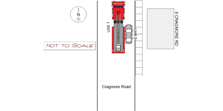
8 CRAGMORE RD
Speed
limit:
25
Violation
cited:
no
Narrative:
On Monday, December 21, 2020, while assigned to Traffic unit N525, I responded to 8 Cragmore Road, Newton for a report of a motor vehicle crash involving a City of Newton Fire apparatus. Cragmore Road is a public way maintained by the City of Newton. The weather at the time of the crash was cloudy. The road surface was wet from melting snow in the area. The operator of MV1, Jon Papia, stated he was operating City of Newton Fire Engine 7 (MA MVN: MF470 ) Southbound on Cragmore Road. As MV1 travelled past 8 Cragmore Road, it's passenger side made contact with the front driver side area of MV2 (MA: 1JTC19). The Honda Accord was parked and unoccupied at the time of the crash. The registered owner was made aware of the crash and advised. I observed no damage to the passenger side of MV1. I observed damage to the front driver side of MV2. Photos were taken and submitted to the IT Bureau. No injuries were reported by any of the involved parties.
Keywords:
Crash, Fire, Pictures, Snow
Dcc:
Inattention
Report
url:
Image
url:
Latitude:
42.3179673
Longitude:
-71.2234986
Location:
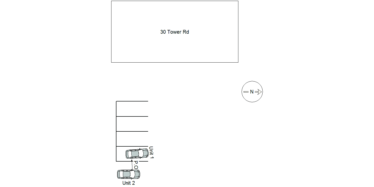
Case
number:
Date:
2020-12-22
Time:
18:06
Address:
30 TOWER RD
Speed
limit:
15
Violation
cited:
no
Narrative:
On Tuesday 12/22/2020, at approximately 1730 hours, I, Ofc Donald Murphy, met a party at the front desk in regards to a hit and run incident. I spoke with Andrew Shvetts, who stated his wife Tetianna Shvets's vehicle was struck today in the parking lot of Baza grocery market from 10 am-11 am. The owner of MV 1, Tetianna Shvets was shopping at Baza grocery market while her vehicle, MV 1, was parked in the parking lot. When Tetianna returned to her vehicle there was a note on her windshield stating MV 2 struck her vehicle "possibly" on the right rear side and left the scene. The plate of the vehicle was left on the note as well. There was no contact information of the witness left on the note or any manner of collision. There was minimal damage (a few scratches) on MV 1. Andrew provided photos of the damage to the vehicle and the note left on the windshield.The photos of the damage and note are attached to this report. The plate came back to 79 Wheeler Rd in Newton. I went to the address to follow up with the operator of MV 2. I spoke with the owner and operator of MV 2, Mrs. Lyuba Regelman. Lyuba admitted to shopping at Baza grocery market today. Lyuba denied hitting MV1 and there was no damage to her vehicle I could see that matched the damage from the incident. I will not be seeking charges on Lyuba for leaving the scene because there is no contact information of the witness and there is no matching damage to MV 2.
Keywords:
Pictures
Dcc:
Unknown
Report
url:
Image
url:
Latitude:
42.3102612
Longitude:
-71.2156323
Location:
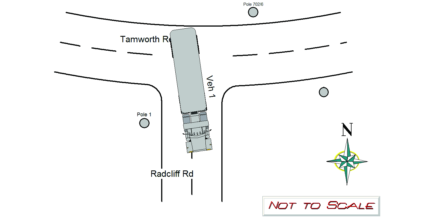
Case
number:
Date:
2020-12-28
Time:
11:59
Address:
RADCLIFF RD & TAMWORTH RD
Speed
limit:
25
Violation
cited:
no
Narrative:
On 12/28/2020 at approx 1159hrs while assigned to 497 I responded to the area of Tamworth Rd for a report of a tractor trailer pulling down wires and utility poles. Upon arrival I observed the intersection of Radcliff Rd and Tamworth Rd blocked by a tractor trailer truck with multiple downed wires and broken telephone poles. I spoke with the operator of the tractor trailer, Lawrence TOGBA who stated he was following the detour off of Chestnut st to Quinobequinn Rd as he has repeatedly in the last several weeks when, this time , likely due to recent storms, the wires were hanging lower getting caught in his truck pulling and causing telephone polls 702/6 and pole 7 on Tamworth Rd to snap and telephone pole 1 on Radcliff Rd to snap. NFD, Eversource and Verizon responded and were able to free the truck from the wires and begin repairs to infrastructure. 526 Traffic Officer Wilson responded and took photos
Keywords:
Fire, Pictures
Dcc:
[]
Report
url:
Image
url:
Latitude:
42.320714
Longitude:
-71.227275
Location:
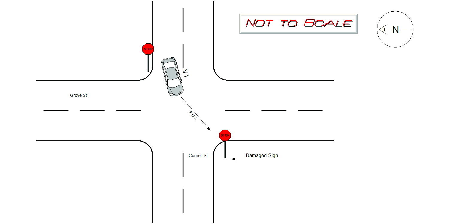
Case
number:
Date:
2020-12-31
Time:
16:57
Address:
GROVE ST & CORNELL ST
Speed
limit:
25
Violation
cited:
no
Narrative:
The operator of vehicle 1 was travelling westbound on Cornell St. Vehicle 1 travelled through the intersection of Cornell and Grove St, and struck the stop sign on the opposite side of Cornell St. The stop sign was completely knocked over. Vehicle 1 was registered to 6 Colgate Cir. I observed vehicle 1 parked in the driveway at 6 Colgate Cir, there was minor damage to the front license plate. No one was injured. Photos were taken of the stop sign, and submitted to the IT bureau.
Keywords:
Pictures
Dcc:
Unknown
Report
url:
Image
url:
Latitude:
42.3295535
Longitude:
-71.2581248
Location:
Advanced export
JSON shape: default, array, newline-delimited, object
CREATE TABLE "crash_reports" (
   [case_number] TEXT PRIMARY KEY,
   [datetime] TEXT,
   [date] TEXT,
   [time] TEXT,
   [address] INTEGER,
   [street1] TEXT,
   [street2] TEXT,
   [intersection] INTEGER,
   [speed_limit] INTEGER,
   [hit_run] INTEGER,
   [violation_cited] INTEGER,
   [narrative] TEXT,
   [keywords] TEXT,
   [dcc] TEXT,
   [dcc_code] TEXT,
   [report_url] TEXT,
   [image_url] TEXT
, [geocoded_address] TEXT, [latitude] TEXT, [longitude] TEXT, [manual_geocode] INTEGER, [retrieved] TEXT);