crash_reports
3 rows where longitude = "-71.2236379"
This data as json, CSV (advanced)
Suggested facets: violation_cited, datetime (date), date (date), retrieved (date), keywords (array), dcc (array)
Case
number:
Date:
2021-05-11
Time:
16:22
Address:
6 CROCKER CIR
Speed
limit:
25
Violation
cited:
no
Narrative:
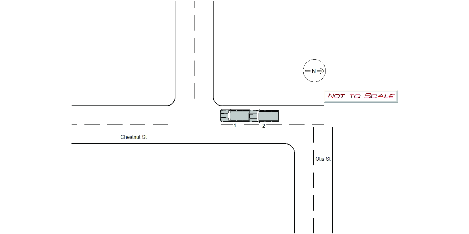
On 5/11/21 at approximately 1630 hours, I responded to the area of Crocker Cir and Chestnut St for a two car accident. Operator 1 stated that he was driving southbound on Chestnut st when a vehicle in front of him had stopped short in causing him to stop short as well. He stated that he was rear ended by Operator 2. He reported no injuries and his vehicle had minor damage. Operator 2 stated that he was driving southbound on Chestnut st when he attempted to stop in time but had rear ended Operator 1. He reported no injuries but his vehicle major damage. He arranged a tow through Audi dealership.
Keywords:
Crash
Dcc:
Followed too closely
Report
url:
Image
url:
Latitude:
42.3445589
Longitude:
-71.2236379
Location:
Case
number:
Date:
2022-04-21
Time:
06:15
Address:
1144 CHESTNUT ST
Speed
limit:
25
Violation
cited:
no
Narrative:
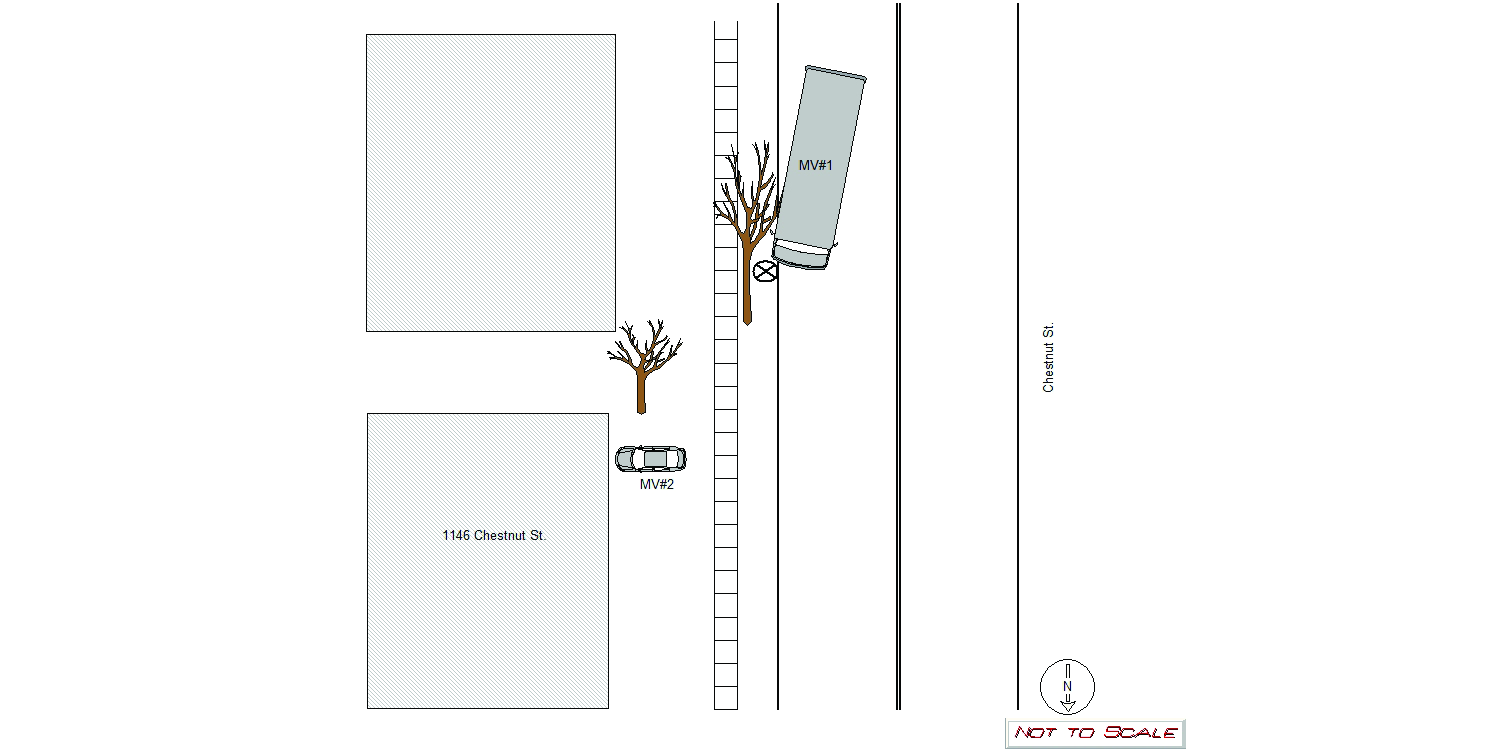
At 0630 hrs.on 4/21/22, Newton Police and Fire were dispatched to the area of 1146 Chestnut St. for a motor vehicle collision into a tree. Upon arrival, MV#1 was observed with damage to its front end and cracked/broken front windshields. The operator of MV#1 stated he had worked all night and had fallen asleep causing the garbage truck he was operating to veer off of the roadway and into the city owned tree in front of 1146 Chestnut St. The tree itself had been knocked over and was across the roadway. A second tree on the property of 1146 Chestnut St. suffered damage. Further, several large tree limbs had fallen a top of MV#2 which was parked in the driveway of 1146 Chestnut St, but no visible damage was observed. The operator of MV#1 declined medical attention and contacted a private tow to remove MV#1 from the roadway. The operator of MV#2 as well as the homeowner of 1146 Chestnut St. were apprised of the situation. Pictures of the damage were taken on the N498 camera and attached to this report.
Keywords:
Fire, Night, Pictures, Tree
Dcc:
Fatigue/Sleep, Unknown
Report
url:
Image
url:
Latitude:
42.3100736
Longitude:
-71.2236379
Location:
Case
number:
Date:
2022-04-23
Time:
13:57
Address:
384 WALTHAM ST
Speed
limit:
25
Violation
cited:
yes
Narrative:
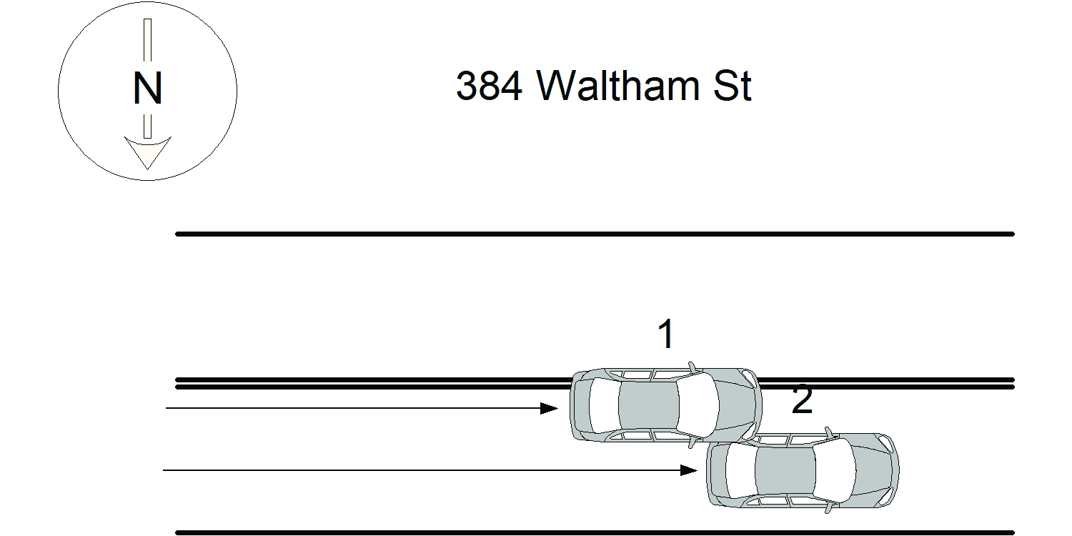
The operator of Vehicle #1 stated that he believed that Vehicle #2 was attempting to park as he attempted to overtake the vehicle on the left side. The operator of Vehicle #2 stated that she was attempting to make a left turn on Eliot St when she collided with Vehicle #1 as he attempted to overtake her vehicle. All parties denied medical attention when it was offered, a Lyft passenger in Vehicle #1 complained of a pain in her side as a result of the collision, but declined medical attention several times. The operator of Vehicle #1 produced a Massachusetts ID, and an expired Florida Driver's License. A routine query could not find an active Driver's License for him. He was cited for a violation of M.G.L. Ch. 90/10-Operating Without a License. As his vehicle's registration was active, and it was in a valid parking spot, he was allowed to leave it to await a licensed operator to drive it.
Keywords:
Citation
Dcc:
Signs/Signals
Report
url:
Image
url:
Latitude:
42.3539939
Longitude:
-71.2236379
Location:
Advanced export
JSON shape: default, array, newline-delimited, object
CREATE TABLE "crash_reports" (
   [case_number] TEXT PRIMARY KEY,
   [datetime] TEXT,
   [date] TEXT,
   [time] TEXT,
   [address] INTEGER,
   [street1] TEXT,
   [street2] TEXT,
   [intersection] INTEGER,
   [speed_limit] INTEGER,
   [hit_run] INTEGER,
   [violation_cited] INTEGER,
   [narrative] TEXT,
   [keywords] TEXT,
   [dcc] TEXT,
   [dcc_code] TEXT,
   [report_url] TEXT,
   [image_url] TEXT
, [geocoded_address] TEXT, [latitude] TEXT, [longitude] TEXT, [manual_geocode] INTEGER, [retrieved] TEXT);