crash_reports
13 rows where "retrieved" is on date 2021-03-01
This data as json, CSV (advanced)
Suggested facets: date, intersection, speed_limit, hit_run, violation_cited, keywords, dcc, dcc_code, datetime (date), date (date), retrieved (date), keywords (array), dcc (array)
Case
number:
Date:
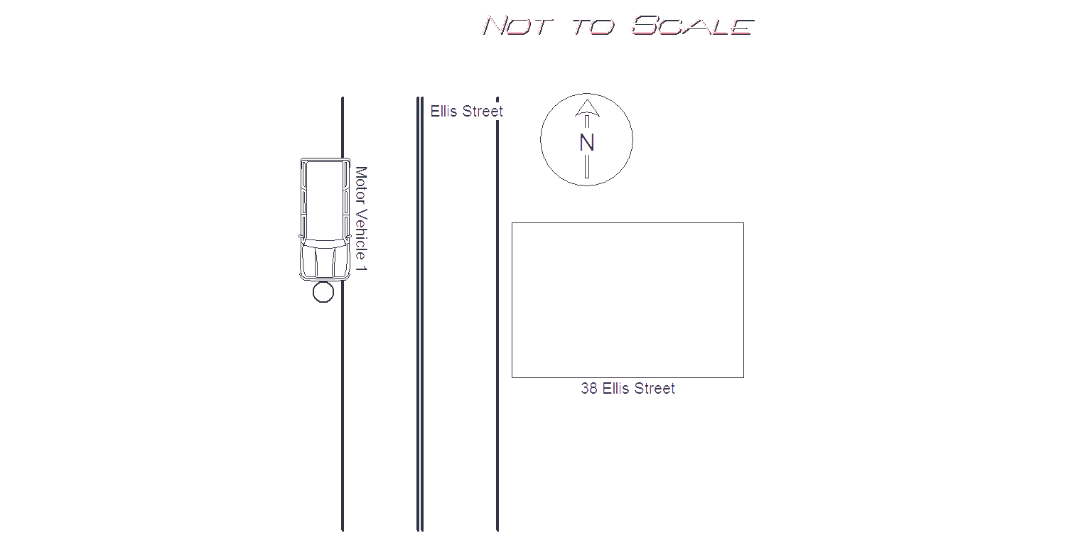
2021-02-17
Time:
14:14
Address:
38 ELLIS ST
Speed
limit:
25
Violation
cited:
no
Narrative:
Motor vehicle 1 (MV1) was traveling southbound on Ellis St. when the operator lost control of the vehicle, hit the curb and then crashed into a telephone pole in front of 38 Ellis St. As a result of the crash MV1 sustained significant front end damage. There did not appear to be any damage to the telephone pole, however, dispatch notified Eversource to come out to check the integrity of the pole. The Fallon medics responded to the scene, and the operator of MV1 signed a patient refusal. MV1 was towed by Todys.
Keywords:
Crash
Dcc:
Over-steering
Report
url:
Image
url:
Latitude:
42.3156373
Longitude:
-71.2264224
Location:
Case
number:
Date:
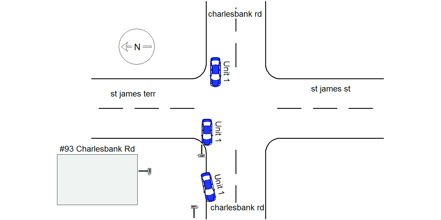
2021-02-20
Time:
09:04
Address:
CHARLESBANK RD & ST JAMES TERR
Speed
limit:
25
Violation
cited:
no
Narrative:
On February 20th, 2021 at approximately 09:04 hours while working N491 I responded to a report of a past hit&run MV crash that involved two US postal mailboxes that had been struck near the intersection of Charlesbank Rd @ St James Terrace. On my arrival to the scene I located the first mailbox on the sidewalk near #93 Charlesbank Rd. The other mailbox was located on the property to #93 Charlesbank Rd upside down leaning up against the front of the house. Dispatch notified the postal authorities and they were going to respond to pick up their mailboxes. The vehicle involved in this MV crash appeared to be a Subaru based on the vehicles damaged parts found at the scene. The vehicle left scene heading W/B on Charlesbank Rd. #94 Charlesbank heard a loud noise around 01:15 this morning but thought it eas just a plow.
Keywords:
Crash
Dcc:
Reckless driving
Report
url:
Image
url:
Latitude:
42.3587668
Longitude:
-71.1802241
Location:
Case
number:
Date:
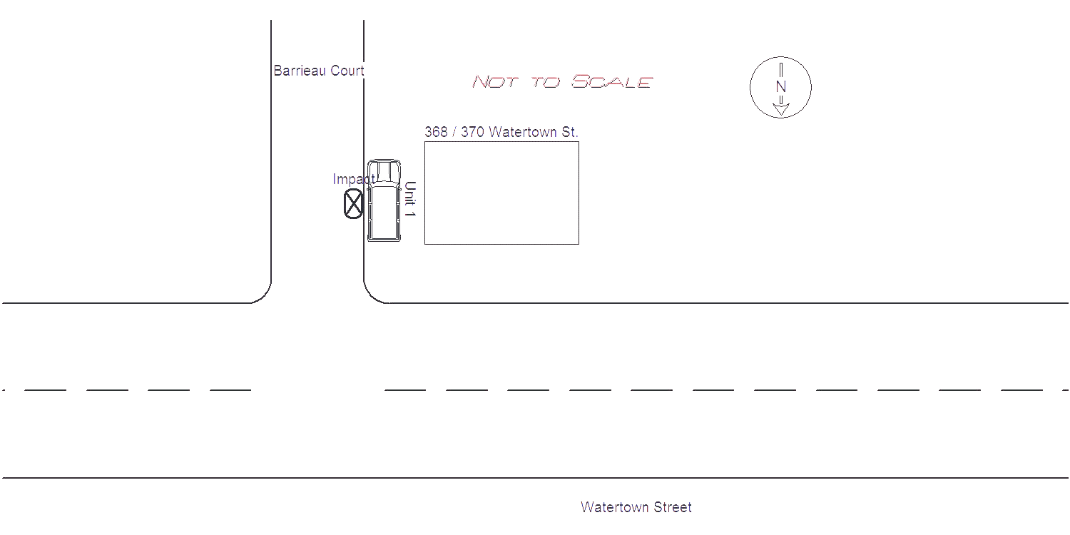
2021-02-20
Time:
11:40
Address:
WATERTOWN ST & BARRIEAU COURT
Speed
limit:
15
Violation
cited:
no
Narrative:
Owner of Veh 1 stated that he believes his car was struck around 4:30 earlier this morning, when he heard a loud noise. His vehicle was parked on Barrieau Court next to 368 Watertown Street. Damage makes owner believe it was hit by a plow during the snow storm. No cameras were located in the area. Owner may call for a tow later due to damage. Owner contacted me to let know that Antonellis Construction plows the area.
Keywords:
Snow
Dcc:
[]
Report
url:
Image
url:
Latitude:
42.3585632
Longitude:
-71.204393
Location:
Case
number:
Date:
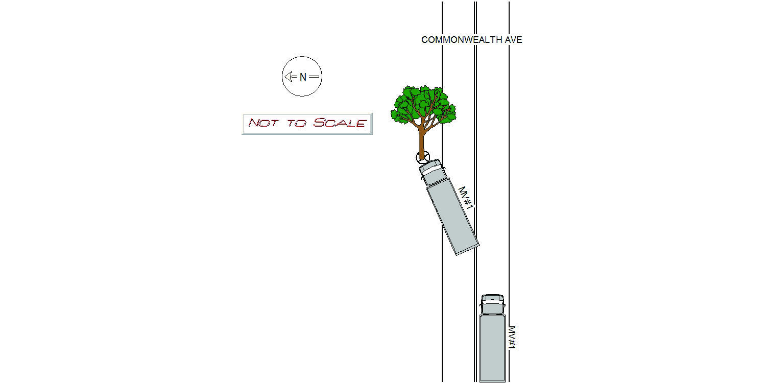
2021-02-19
Time:
23:16
Address:
2285 COMMONWEALTH AVE
Speed
limit:
30
Violation
cited:
no
Narrative:
MV#1 Was traveling Eastbound on Commonwealth Ave when his vehicle started to lose control due to the winter conditions. MV#1 swerved into the Westbound lane and collided with a tree. OPMV#1 Stated he lost control due to the snow on the street and couldn't stop before he hit the tree. Vehicle towed by Tody's Towing.
Keywords:
Snow, Tree
Dcc:
Unknown
Report
url:
Image
url:
Latitude:
42.3470349
Longitude:
-71.256076
Location:
Case
number:
Date:
2021-02-22
Time:
07:39
Address:
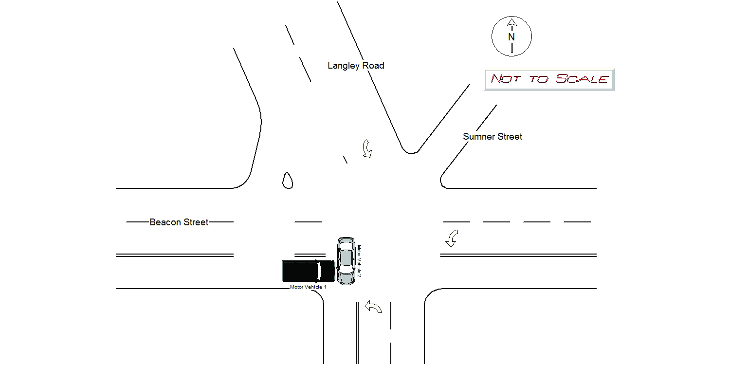
BEACON ST & LANGLEY RD
Speed
limit:
25
Violation
cited:
yes
Narrative:
Motor vehicle 1 (MV1) was traveling eastbound on Beacon street, crossing though the intersection of Langley Rd., when motor vehicle 2 (MV2), which was traveling southbound on Langley Rd. also attempted to cross through the intersection, and crashed into MV1. It should be noted that the traffic lights at the Beacon St. and Langley Rd. intersection were on flash at the time of the crash. MV1 had a blinking yellow light, while MV2 had a blinking red light. As a result of the crash, MV1 sustained moderated front end damage, while MV2 sustained moderate passengers side damage. MV1 was towed by Tody's. No injuries were reported on scene. Operator of MV2 had an active Guatemalan license (License #110171027000127)
Keywords:
Crash, Moderate
Dcc:
Failed to yield
Report
url:
Image
url:
Latitude:
42.3304423
Longitude:
-71.1922769
Location:
Case
number:
Date:
2021-02-22
Time:
08:49
Address:
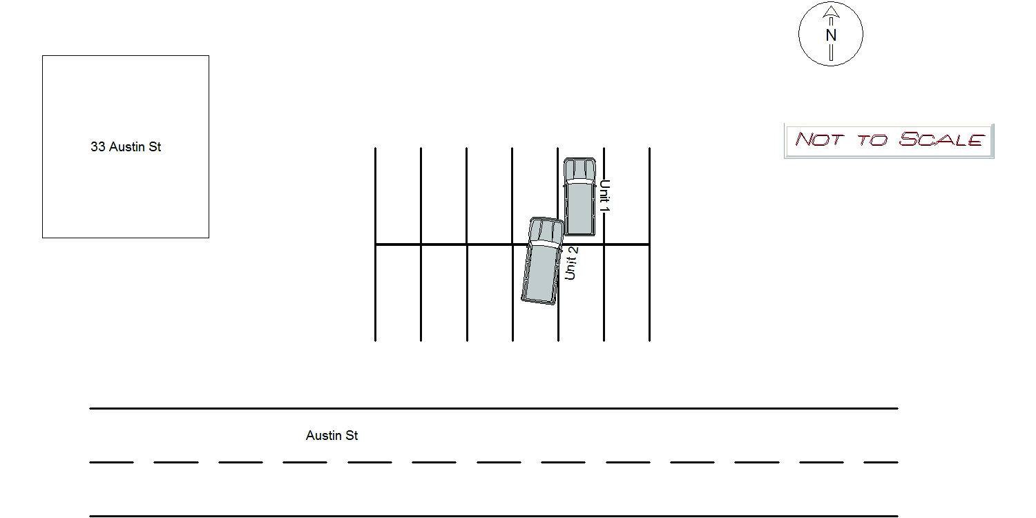
33 AUSTIN ST
Speed
limit:
5
Violation
cited:
yes
Narrative:
On Monday 2/22/2021 at approx 0849hrs, while assigned to N491, I responded to 33 Austin St in Newton for a MVA hit and run. There I was met by the owner of MV1 who states that his car was parked in the Austin St lot while getting coffee at Starbucks. He states that a witness to the accident gave him their information. Witness statement: Schreiner states that she had just left Starbucks and heard a crash. When she looked into the Austin St parking lot she could see MV2 make contact with MV1. She said that MV2 then scrapped the side of MV1 with the front passenger side of the vehicle. When MV2 left the parking lot she said that she was able to read the MA plate of 1NTE29. Schreiner said that MV2 was white and looked like a Toyota Highlander operated by a white female w/ blonde hair in her 40's. It is unclear at this time who was operating MV2(MA# 1NTE29). Dracut PD was contacted about the registered owner and I was able to get a phone number. However, the number was to a business she hasn't worked at in five years. Traffic Bureau update (Officer Gaudet): On Monday, February 22, 2021 I was able to make contact with the registered owner of MV2, Ms. Melinda Russo (S29162725). Ms. Russo stated that she was operating her white 2019 Toyota Highlander (MA: 1NTE29) in the Austin Street municipal parking lot this morning. Ms. Russo stated she was backing out of a parking spot when she observed her passenger side mirror collapse in. Ms. Russo stated after she exited the parking spot she pulled her vehicle over and observed no damage to the passenger door mirror area. Ms. Russo stated she fixed her mirror and then left the area. Ms. Russo stated she did not think there would be damage to any other vehicle because she did not have damage on her vehicle. Ms. Russo was advised that if she believes she was involved in a crash, she should make every effort to contact the owner of the other vehicle. Ms. Russo was also advised she can contact the police department for assistance. Ms. Russo will be mailled Massachusetts Uniform Citation T1446762 for Newton City Ordinance Chapter 19, Section 75 (Fail to Use Care). Austin Street is a public way maintained by the City of Newton.
Keywords:
Bus, Citation, Crash, Phone
Dcc:
Other improper action
Report
url:
Image
url:
Latitude:
42.3498004
Longitude:
-71.2087985
Location:
Case
number:
Date:
2021-02-22
Time:
10:37
Address:
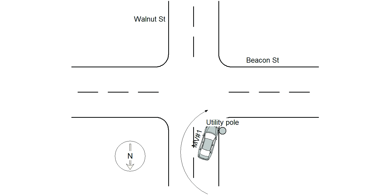
BEACON ST & WALNUT ST
Speed
limit:
30
Violation
cited:
no
Narrative:
The operator of MV#1 stated he was travelling southbound on Walnut St making a right turn onto Beacon St when he went over the curb (Snow mound) and struck a utility pole. The operator of MV#1 stated he suffers from a neurological medical condition and typically walks with a folding walker. He was evaluated by Newton Paramedics and signed a patient refusal of treatment. While he was speaking to the Paramedics, it was apparent that he was unstable on his feet but was able to walk on his own will. His portable walker was located in the back seat of his vehicle. He appeared to be of sound mind. His daughter in-law picked him up and drove him home. MV#1 sustained damages to its passenger side front wheel area. MV#1 was towed by Tody's Towing. The utility pole (Boston Edison pole #31/107) that was struck is located on Walnut St southbound at the intersection of Beacon St westbound. The pole sustained minor damages to its base. Traffic Officer took pictures of the damaged pole and Boston Edison was notified. Based on the statements made to me and the health condition of the operator of MV#1, I believe his continued operation would constitute an immediate threat to the public safety. A request for immediate threat of license suspension/ revocation form was completed and emailed to the R.M.V.
Keywords:
Pictures, Walk
Dcc:
Lane departure
Report
url:
Image
url:
Latitude:
42.3308369
Longitude:
-71.2070206
Location:
Case
number:
Date:
2021-02-22
Time:
17:03
Address:
427 WATERTOWN ST
Speed
limit:
15
Violation
cited:
no
Narrative:
The operator of Vehicle #1 stated that she was sitting in her parked motor vehicle when the rear driver's side was struck by Vehicle #2 causing minor damage. Vehicle #2 then left the area. When I spoke with the operator of Vehicle #2 he stated that was unaware that he struck a vehicle, but "that doesn't mean it didn't happen". He also reported that his vehicle was not damaged. Neither party complained of injury when they were asked. This occured in the rear parking lot of 425 Watertown St.
Keywords:
[]
Dcc:
Unknown
Report
url:
Image
url:
Latitude:
42.3596277
Longitude:
-71.203289

Location:
Case
number:
Date:
2021-02-23
Time:
08:02
Address:
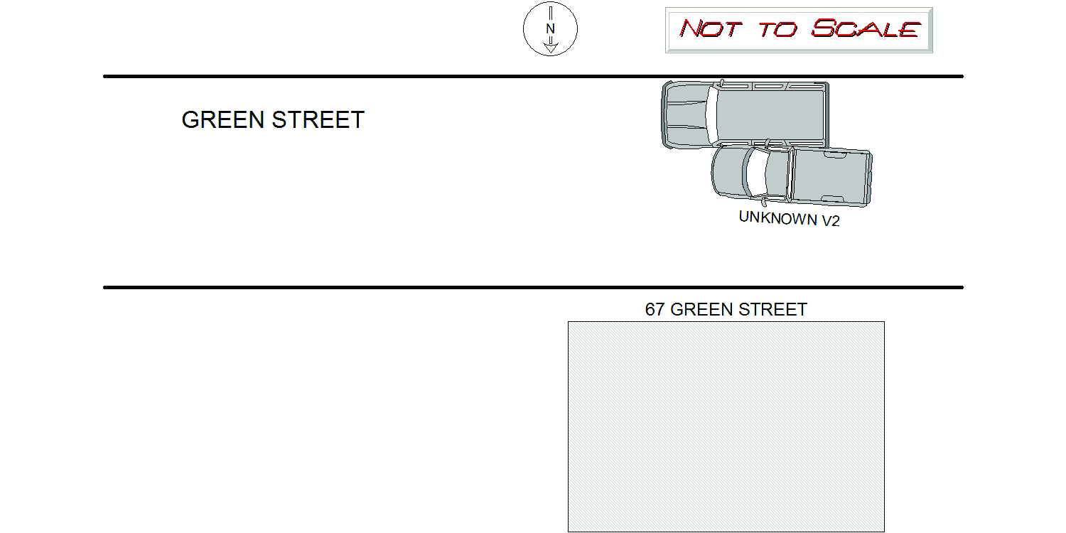
67 GREEN ST
Speed
limit:
25
Violation
cited:
no
Narrative:
On Tuesday February 23, 2021 at approx 0800 hours I responded to 67 Green Street for a report of a past hit/run. Owner of V1 stated vehicle was parked opposite 67 Green Street at approx. 1530 hours on Monday February 22, 2021. When owner came out this morning she noticed the damage to her driver side. It should be noted another vehicle was struck on drivers side at 58 Green Street. I canvassed the area for any video, video door bells I found in area are only limited to their porch. This hit/run possibly happened on February 22, 2021 between 1730 hours through 1900 hours.
Keywords:
[]
Dcc:
Unknown
Report
url:
Image
url:
Latitude:
42.3583722
Longitude:
-71.1982998
Location:
Case
number:
Date:
2021-02-23
Time:
08:53
Address:
58 GREEN ST
Speed
limit:
25
Violation
cited:
no
Narrative:
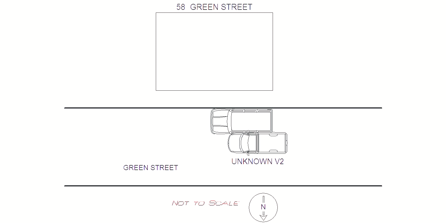
On Tuesday February 23, 2021 at approx 0800 hours I responded to 58 Green Street for a report of a past hit/run. Owner of V1 stated vehicle was parked at 58 Green Street at approx. 1730 hours on Monday February 22, 2021. When owner came out this morning she noticed the damage to her driver side. She stated a neighbor observed the damage at approx. 1900 last night. It should be noted another vehicle was struck on drivers side at 67 Green Street. I canvassed the area for any video, video door bells I found in area are only limited to their porch. This hit/run possibly happened on February 22, 2021 between 1730 hours through 1900 hours.
Keywords:
Night
Dcc:
Unknown
Report
url:
Image
url:
Latitude:
42.35838
Longitude:
-71.1977875
Location:
Case
number:
Date:
2021-02-23
Time:
12:05
Address:
2370 COMMONWEALTH AVE
Speed
limit:
5
Violation
cited:
no
Narrative:
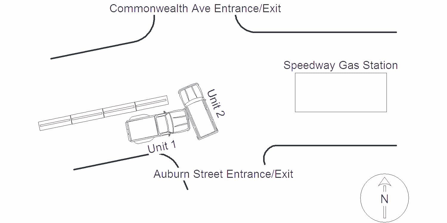
MV #1 was parked and unoccupied at #2370 Commonwealth Ave., The Speedway Gas Station at the time of the crash. The operator of MV#2 stated that she was entering the Speedway Gas Station at the south entrance/exit and attempted to go around MV#1 when crash occurred. No injuries, no tows.
Keywords:
Crash, Speed
Dcc:
Unknown
Report
url:
Image
url:
Latitude:
42.344635
Longitude:
-71.258199
Location:
Case
number:
Date:
2021-02-23
Time:
19:01
Address:
LOWELL AVE & OTIS ST
Speed
limit:
25
Violation
cited:
no
Narrative:
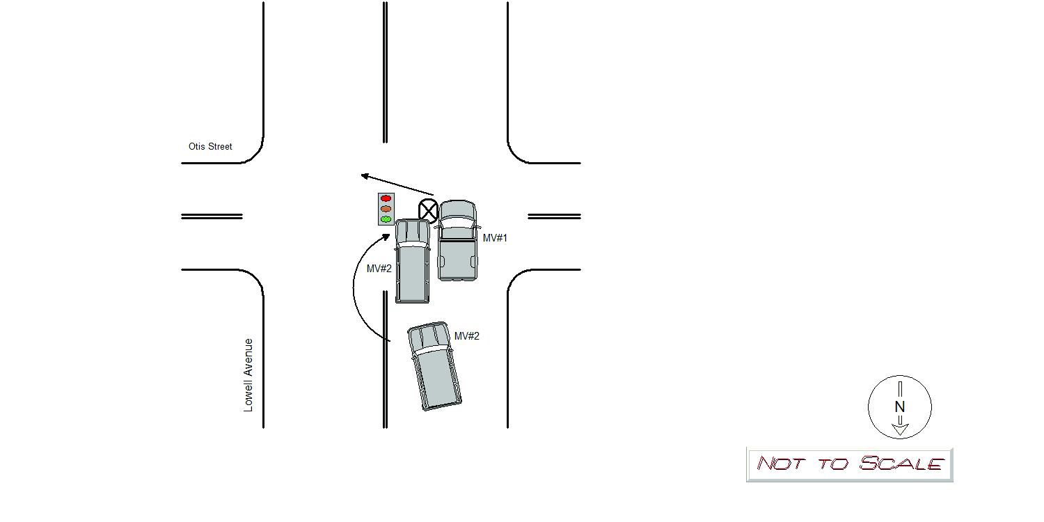
On 2/23/21 at 1900 hrs, Newton Police were dispatched to the intersection of; Lowell Ave. at Otis St. for a motor vehicle collision involving two vehicles. The operator of MV#1 stated they were attempting to turn eastbound onto Otis St. from Lowell Ave. when MV#2 began to pass MV#1 on the left. As MV#2 was passing MV#1, MV#2's passenger side collided with MV#1's front snow plow. Extensive damage was observed to MV#2's passenger side rear and front door, while also puncturing MV#2's passenger side rear tire. No damage was observed to MV#1. The operator of MV#2 stated he attempted to pass MV#1 on the left, as he believed MV#1 was going to turn right onto Otis St. No injuries were reported and MV#2 was towed from the scene by Tody's Towing Service, while MV#1 was driven from the scene.
Keywords:
Severe, Snow
Dcc:
Wrong way
Report
url:
Image
url:
Latitude:
42.3473475
Longitude:
-71.2108849
Location:
Case
number:
Date:
2021-02-26
Time:
07:42
Address:
42 PARSONS ST
Speed
limit:
30
Violation
cited:
no
Narrative:
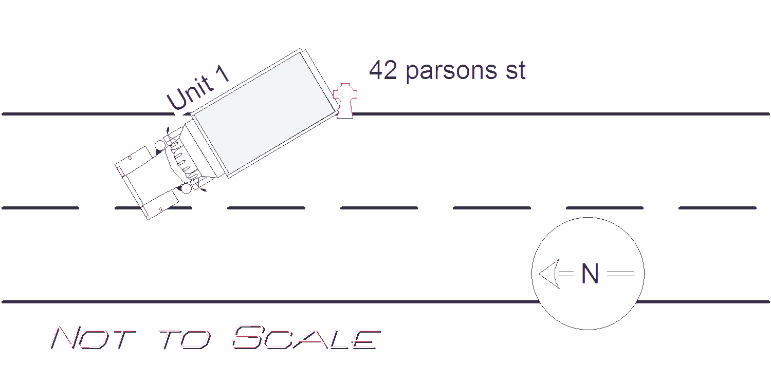
ON 2-26-21 AT APPROX. 0742HRS. WHILE WORKING N492 I TOOK A REPORT FOR MOTOR VEHICLE ACCIDENT. UPON ARRIVAL AT 42 PARSONS ST. I SPOKE TO THE OPERATOR OF VEHICLE #1. DRIVER STATES HE WAS BACKING ONTO THE RESIDENCE AT 42 PARSONS ST. TO EMPTY THE PORTA-POTTY AT THIS SITE. DRIVER STATES WHILE BACKING HE THOUGHT HE WAS CLEAR THE FIRE HYDRANT.BUT DIDN'T REALIZE HE WASN'T UNTIL HE HIT THE HYDRANT KNOCKING IT OVER. I TOOK 4 PICTURES OF THE HYDRANT AND PLACED THEM IN I.T. BOX. VEHICLE #1 HAD MINOR REAR LEFT DAMAGE. DRIVER REPORTED NO INJURY AND WAS ADVISED TO CONTACT HIS INSURANCE COMPANY. CITY OF NEWTON NOTIFIED TO GET THE HYDRANT. CLEARED WITHOUT FURTHER INCIDENT. CITY DPW NOTIFIED OF DAMAGE.
Keywords:
Crash, Fire, Pictures
Dcc:
Inattention
Report
url:
Image
url:
Latitude:
42.3511954
Longitude:
-71.2174191
Location:
Advanced export
JSON shape: default, array, newline-delimited, object
CREATE TABLE "crash_reports" (
   [case_number] TEXT PRIMARY KEY,
   [datetime] TEXT,
   [date] TEXT,
   [time] TEXT,
   [address] INTEGER,
   [street1] TEXT,
   [street2] TEXT,
   [intersection] INTEGER,
   [speed_limit] INTEGER,
   [hit_run] INTEGER,
   [violation_cited] INTEGER,
   [narrative] TEXT,
   [keywords] TEXT,
   [dcc] TEXT,
   [dcc_code] TEXT,
   [report_url] TEXT,
   [image_url] TEXT
, [geocoded_address] TEXT, [latitude] TEXT, [longitude] TEXT, [manual_geocode] INTEGER, [retrieved] TEXT);