crash_reports
7 rows where "date" is on date 2019-02-12 and keywords contains "Snow"
This data as json, CSV (advanced)
Suggested facets: intersection, speed_limit, hit_run, violation_cited, dcc, dcc_code, datetime (date), date (date), retrieved (date), keywords (array), dcc (array)
Case
number:
Date:
2019-02-12
Time:
14:02
Address:
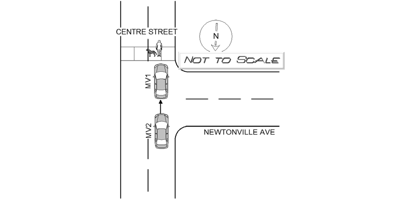
CENTRE ST & NEWTONVILLE AVE
Speed
limit:
30
Violation
cited:
no
Narrative:
OPERATOR OF MV 1 STATED SHE WAS TRAVELING SOUTH ON CENTRE ST WHEN SHE STOPPED AT THE CROSSWALK AT INTERSECTION OF NEWTONVILLE AVE AND CENTRE ST FOR A PEDESTRIAN WALKING THEIR DOG. ONCE MV 1 CAME TO A COMPLETE STOP THEY WERE STRUCK IN THE REAR BY MV 2. MV 1 WAS UNABLE TO GET A LICENSE PLATE OR A DESCRIPTION DUE TO THE WEATHER (HEAVY SNOW) AND THE FACT THAT THEY JUST PULLED OVER TO THE SIDE AND ASSUMED MV 2 WOULD DO THE SAME. MV 2 NEVER PULLED OVER TO EXCHANGE INFORMATION AND CONTINUED GOING SOUTH ON CENTRE STREET. MV 1 SUSTAINED MODERATE REAR END DAMAGE AND NO INJURIES REPORTED. THERE WAS A PARTIAL PLATE GIVEN BY THE PEDESTRIAN CROSSING THE STREET OF 915.
Keywords:
Crosswalk, Moderate, Ped, Snow, Walk
Dcc:
[]
Report
url:
Image
url:
Latitude:
42.3515559
Longitude:
-71.1861175
Location:
Case
number:
Date:
2019-02-12
Time:
14:30
Address:
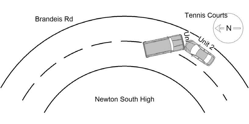
140 BRANDEIS RD
Speed
limit:
30
Violation
cited:
no
Narrative:
VEHICLE #1 WAS DRIVING DOWN BRANDEIS RD IN FRONT OF NEWTON SOUTH HIGH SCHOOL.IN A SNOW STORM. AS HE WAS TURNING THE CORNER IN FRONT OF THE TENNIS COURTS, HIS CAR SKIDDED ON THE UNTREATED AND UNPLOWED ROAD, INTO VEHICLE #2 WHO WAS HEADED IN THE OPPOSITE DIRECTION. NO INJURIES REPORTED. BOTH VEHICLES TOWED BY TODYS'S TOWING OF NEWTON.
Keywords:
School, Snow
Dcc:
[]
Report
url:
Image
url:
Latitude:
42.3135234
Longitude:
-71.1865424
Location:
Case
number:
Date:
2019-02-12
Time:
14:32
Address:
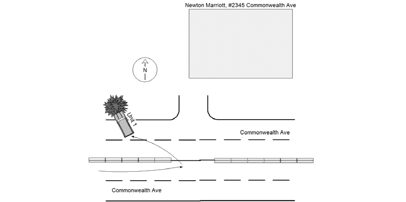
2345 COMMONWEALTH AVE
Speed
limit:
35
Violation
cited:
no
Narrative:
The operator of MV#1 stated that she had just made a U-Turn from the east bound side of Commonwealth Ave (#2345) to the west bound side when her MV started to slide in the fresh snow. MV then slid across Commonwealth Ave and hit the curb and then head on into a large tree. Operator arranged for their own tow.
Keywords:
Snow, Tree
Dcc:
[]
Report
url:
Image
url:
Latitude:
42.346364
Longitude:
-71.2584662
Location:
Case
number:
Date:
2019-02-12
Time:
15:45
Address:
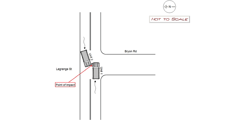
BRYON RD & LAGRANGE ST
Speed
limit:
25
Violation
cited:
no
Narrative:
Operator of MV1 states he was traveling eastbound on Lagrange St approaching Bryon Rd when MV2 made an "unusual" left turn attempting to travel southbound on Bryon Rd. Operator of MV1 states when MV2 made the left turn, MV2 collided with MV1 causing damage to the left front corner panel and drivers side door. Operator of MV2 states he was traveling westbound on Lagrange St approaching Bryon Rd to take a left turn traveling southbound on Bryon Rd. Operator of MV2 states while making the left turn, MV1 looked like it attempted to come to a stop but slid due to the snow and slippery road conditions. Operator of MV2 states his tires spun out attempting to make the turn and struck MV1 with the front left corner panel causing significant damage. It should be noted the weather during this time was heavy snow with wet and slippery road conditions, which is a determining factor on how the accident happened.
Keywords:
Crash, Snow
Dcc:
[]
Report
url:
Image
url:
Latitude:
42.3017711
Longitude:
-71.1689697
Location:
Case
number:
Date:
2019-02-12
Time:
21:32
Address:
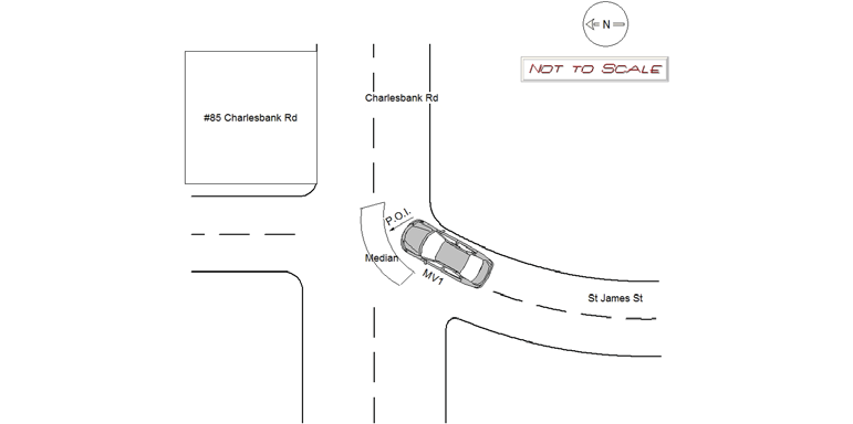
85 CHARLESBANK RD
Speed
limit:
25
Violation
cited:
no
Narrative:
Operator of MV1 was travelling northbound on St James Street. As he approached the intersection of Charlesbank Rd, he began to brake to turn right. Due to the slippery snow and ice conditions, his brakes locked up and he skidded straight into the median in front of 85 Charlesbank Rd. The vehicle sustained major damage to the drivers side front axle, hood and under carriage. Operator of MV1 stated he was not injured and declined medical attention. He had called for a private tow. Tonys Towing responded to towed the vehicle.
Keywords:
Ice, Snow
Dcc:
[]
Report
url:
Image
url:
Latitude:
42.3588929
Longitude:
-71.1800115
Location:
Case
number:
Date:
2019-02-12
Time:
14:50
Address:
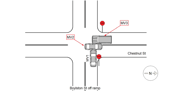
BOYLSTON ST & CHESTNUT ST
Speed
limit:
15
Violation
cited:
yes
Narrative:
MV1 was coming down the Rte 9 West off ramp to Chestnut St. Operator was traveling too fast for the snowy road conditions and failed to stop for the stop sign at the bottom of the ramp. A snow storm had started 2 hours prior to the accident and road conditions were slippery. MV1 struck MV2 broadside who was traveling north on Chestnut St with the right of way. MV1 struck MV2 hard enough that MV2 was pushed across the lane and into MV3 that was stopped at the stop sign southbound. According to the operator of MV2, MV1 was traveling "way too fast for conditions" over 30mph. Operator MV1 was cited for 89/9 failed to stop for stop sign and 90/17 speeding too fast for road conditions. Operator was also cited on Citation T1272992 for 90/23 operating after suspended license. Boylston St and Chestnut St are public ways in the city of Newton.
Keywords:
Citation, Crash, Snow, Speed
Dcc:
Signs/Signals, Too fast for conditions
Report
url:
Image
url:
Latitude:
42.3169482
Longitude:
-71.2257627
Location:
Case
number:
Date:
2019-02-12
Time:
14:45
Address:
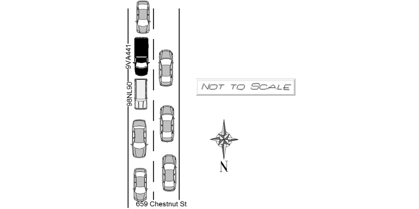
659 CHESTNUT ST
Speed
limit:
25
Violation
cited:
no
Narrative:
On 2/12/2018 at approx 1445hrs while assigned to 497 I responded to the area of 659 Chestnut St for a report of a two car crash . Upon arrival Ma Reg 9VA441 being operated by Steven HUTCHINSON and Ma Reg 98NL90 being operated by Vi DANG were pulled to the side of the road, there was a heavy snowfall and the road had accumulated a thick layer of snow and multiple crashes were occurring. NFD was on scene , DANG was crying and hysterical despite the minor nature of the crash and zero damage to either vehicle. HUTCHINSON stated they were creeping along NB on Chestnut St when DANG stopped, HUTCHINSON attempted to stop and his 4wd engaged and he slid slightly into the back of DANGS car, no marks or damage to either car. DANG elected to go to NWH with Cataldo . DANGs veh towed so as not to obstruct roadway.
Keywords:
Crash, Fire, Snow
Dcc:
[]
Report
url:
Image
url:
Latitude:
42.3272407
Longitude:
-71.2264688
Location:
Advanced export
JSON shape: default, array, newline-delimited, object
CREATE TABLE "crash_reports" (
   [case_number] TEXT PRIMARY KEY,
   [datetime] TEXT,
   [date] TEXT,
   [time] TEXT,
   [address] INTEGER,
   [street1] TEXT,
   [street2] TEXT,
   [intersection] INTEGER,
   [speed_limit] INTEGER,
   [hit_run] INTEGER,
   [violation_cited] INTEGER,
   [narrative] TEXT,
   [keywords] TEXT,
   [dcc] TEXT,
   [dcc_code] TEXT,
   [report_url] TEXT,
   [image_url] TEXT
, [geocoded_address] TEXT, [latitude] TEXT, [longitude] TEXT, [manual_geocode] INTEGER, [retrieved] TEXT);