crash_reports
2 rows where "datetime" is on date 2022-04-21, intersection = 0 and keywords contains "Speed"
This data as json, CSV (advanced)
Suggested facets: datetime (date), date (date), retrieved (date), keywords (array), dcc (array)
Case
number:
Date:
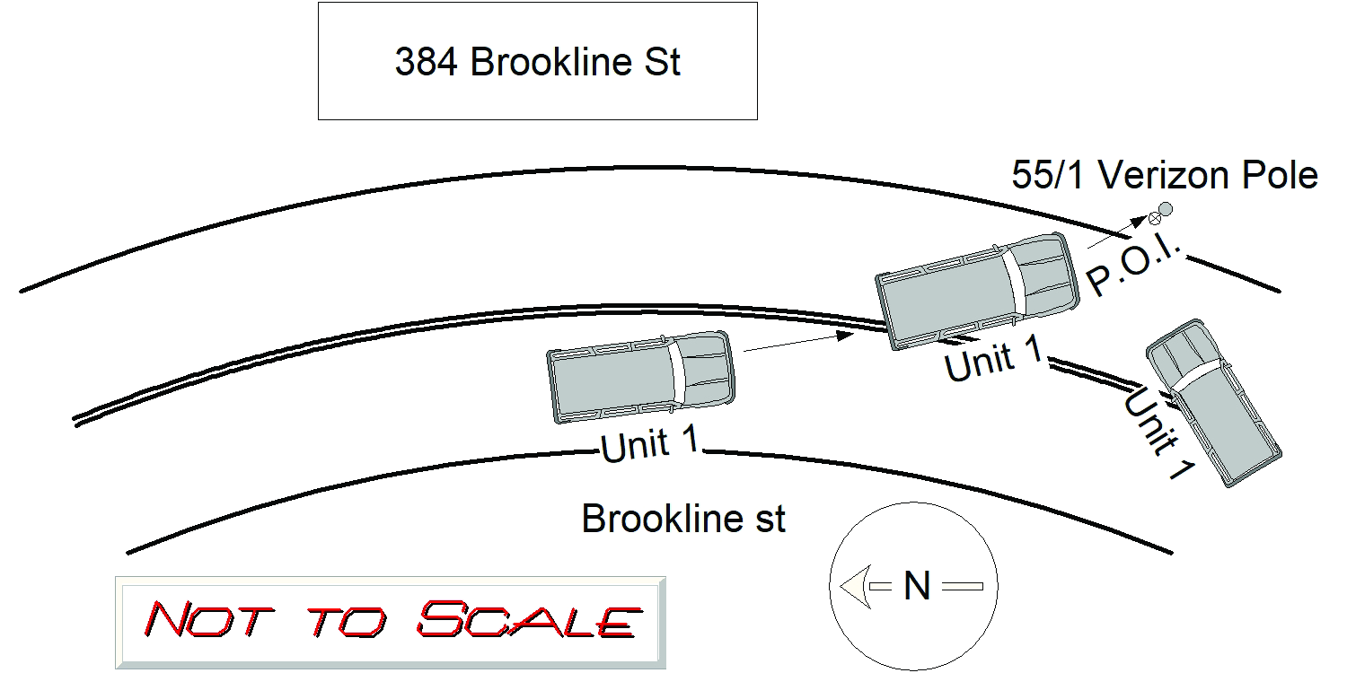
2022-04-21
Time:
17:23
Address:
384 BROOKLINE ST
Speed
limit:
30
Violation
cited:
yes
Narrative:
OPERATOR 1 OF MV 1 WAS TRAVELING S/B ON BROOKLINE ST BY REDWOOD RD AND STATED THEY WERE TRAVELING GREATER (APPROX 40MPH) THAN THE POSTED SPEED LIMIT (30MPH) AND LOST CONTROL OF THE CAR AND CROSSED OVER THE DOUBLE YELLOW LINE AND STRUCK THE VERIZON UTILITY POLE (POLE #55/1) PASSENGER WAS INJURED AND TRANSPORTED TO THE BI NEEDHAM. OPERATOR WAS NOT INJURED AND SIGNED A REFUSAL WITH MEDICS. MAJOR DAMAGE TO MV 1, TOWED BY TODYS. VERIZON NOTIFIED FOR THE DAMAGE TO THE POLE. CITATION ISSUED TO OPERATOR 1 (MA T2012684) FOR c89s4A MARKED LANES VIOLATION AND c90s17 SPEEDING. TOWED MV SHEET COMPLETED PER DEPT PROTOCOL.
Keywords:
Citation, Speed
Dcc:
Speeding
Report
url:
Image
url:
Latitude:
42.3011172
Longitude:
-71.1828427
Location:
Case
number:
Date:
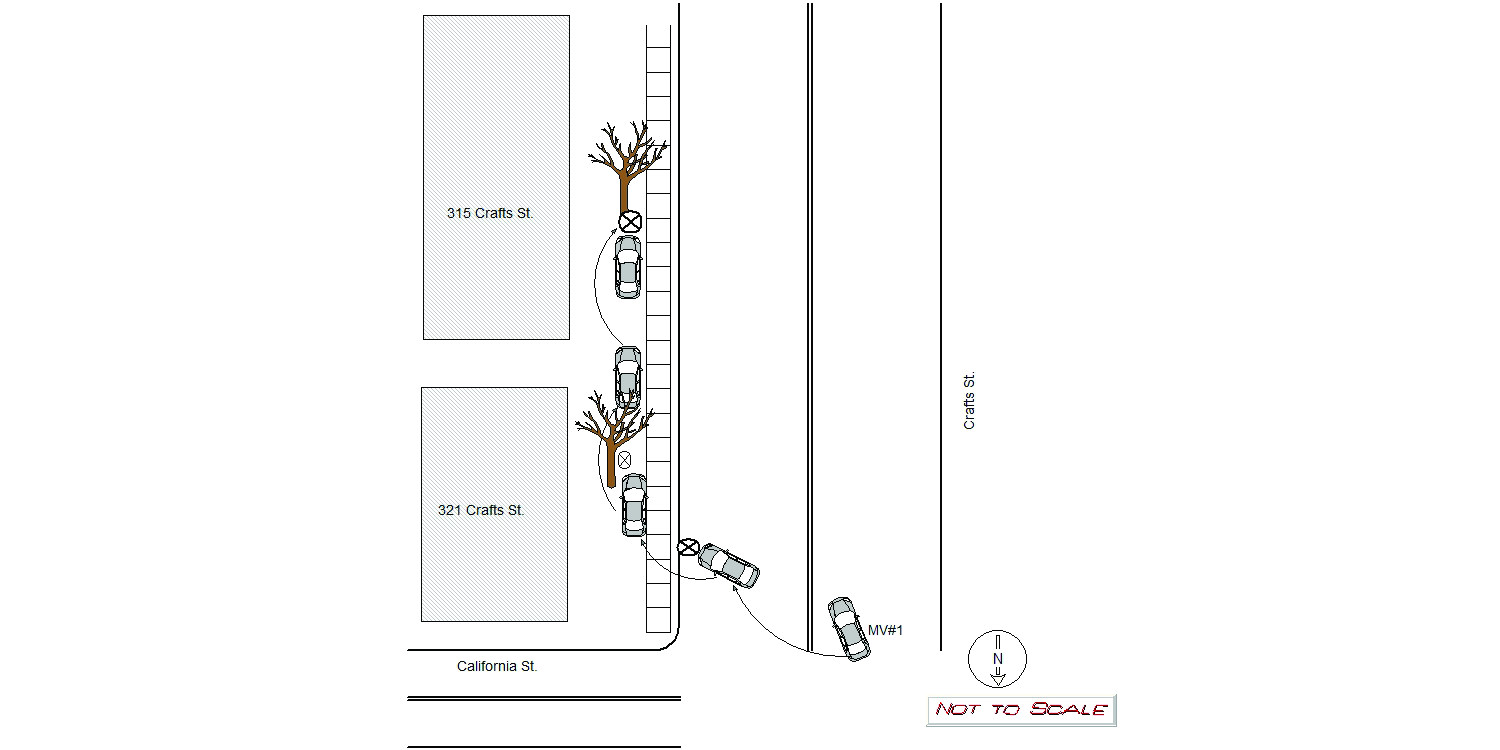
2022-04-21
Time:
23:52
Address:
318 CRAFTS ST
Speed
limit:
25
Violation
cited:
yes
Narrative:
On 4/21/22, I was dispatched to the intersection of Crafts St./California St. for a motor vehicle collision involving a single vehicle into a tree. Upon arrival, I observed MV#1 had crashed into a tree in front of 315 Craft St. The operator stated the "road was slippery" and he veered off the roadway, hitting the curb, before traveling 20-25 yards on the sidewalk, hitting two tree's. MV#1 sustained heavy front end damage and air bag deployment consistent with colliding into a tree at a decent rate of speed. MV#1 was removed from the roadway by Tody's Tow Service. The operator of Mv#1 was transported to Newton-Wellesley Hospital with injuries. Charges pending at this time for OUI Liquor 2nd Offense, Marked Lanes Violation and Negligent Operation of a Motor Vehicle.
Keywords:
Crash, Hospital, Speed, Tree
Dcc:
Reckless driving
Report
url:
Image
url:
Latitude:
42.358935
Longitude:
-71.2125693
Location:
Advanced export
JSON shape: default, array, newline-delimited, object
CREATE TABLE "crash_reports" (
   [case_number] TEXT PRIMARY KEY,
   [datetime] TEXT,
   [date] TEXT,
   [time] TEXT,
   [address] INTEGER,
   [street1] TEXT,
   [street2] TEXT,
   [intersection] INTEGER,
   [speed_limit] INTEGER,
   [hit_run] INTEGER,
   [violation_cited] INTEGER,
   [narrative] TEXT,
   [keywords] TEXT,
   [dcc] TEXT,
   [dcc_code] TEXT,
   [report_url] TEXT,
   [image_url] TEXT
, [geocoded_address] TEXT, [latitude] TEXT, [longitude] TEXT, [manual_geocode] INTEGER, [retrieved] TEXT);